
Glarus Alps
| Glarus Alps | |
|---|---|
 |
|
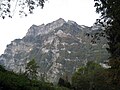
 The Tödi seen from Braunwald 3614 m above sea level. M. |
|
| Highest peak | Tödi ( 3614 m above sea level ) |
| part of | Western alps |
| Coordinates | 724 653 / 193.83 thousand |
| surface | 1,900 km² |
The Glarus Alps are a mountain group in Switzerland in the northeastern part of the Western Alps , which extends to the cantons of Glarus , Uri , Graubünden and St. Gallen . There are numerous three-thousand-meter peaks as well as some glaciers. Its highest peak is the Piz Russein at 3614 m above sea level. M. in the mountain range of the Tödi .
Location and area
The area is (clockwise from North) bordered by Walensee and Seez against the Appenzeller Alps , from Rhein against Raetikon and Plessur Alps , from front Rhein against the Adula group , from the upper front Rhein, Oberalppass and Oberalp Reuss against the Gotthard group , of the Reuss against the Urner Alps , from Schächen , Vorder Schächen , Klausenpass , Fätschbach and Linth against the Schwyzer Alps ; they cover an area of 1900 km².
structure
At the south-west corner of the group is the main ridge, which extends in a north-easterly direction parallel to the Vorderrhein and forks into three branches. In the southwest, another ridge runs parallel to the main ridge, which contains the Gross Windgallen . In the east there is an independent ridge.
Valleys and places
Inside the group are Murgtal , Schilstal, Weisstannental , Vättis in the Tamina valley , Calfeisental , Kunkelstal, Maderanertal and Elm in the Sernftal ; on its edge are Glarus , Mühlehorn , Flums , Mels , Bad Ragaz , Tamins , Ilanz , Trun , Disentis , Andermatt , Göschenen , Erstfeld , Linthal , and Schwanden . In the north, the Walensee is its lowest point at 419 m above sea level. M. , which results in a difference to the highest of 3195 m.
summit
Three thousand meter peaks
There are 51 named three-thousand-meter peaks in the Glarus Alps . These are, in order of height above sea level. M .:
|
|
|
Protected areas
Glarus Thrust World Heritage Site
The Glarus thrust was included in the UNESCO World Heritage Site in 2009 .
Landscapes of national importance
In accordance with Article 5 of the Federal Act on Nature Conservation and Heritage Protection, Switzerland keeps a federal inventory of landscapes and natural monuments of national importance .
There are currently seven of these landscapes in the Glarus Alps:
- No. 1602, designation: Murgtal - Mürtschental , year of inclusion in the inventory: 1977, size: 4210 hectares, description: beautiful valley characterized by two lakes, not affected by interventions. Geologically and morphologically richly structured. Particularly remarkable flora, due to the changing rock base. In the higher elevations, populations of Swiss stone pine in connection with mountain pine and alpine rose bushes.
- No. 1603, designation: Maderanertal - Fellital , year of inclusion in the inventory: 1977, size: 16,176 hectares, description: Beautiful high alpine valleys in the Aar massif and its sediment mantle, hardly changed by technology. Rich in minerals. Naturally flowing powerful brooks. Diverse flora due to the alternation of primary rock and limestone. The pine forest on Felligrat is remarkable for Central Switzerland. Wealth of game.
- No. 1610, name: Scheidnössli near Erstfeld , year of inclusion in the inventory: 1983, size: 5 hectares
- No. 1611, description: Lochseite near Schwanden , year of inclusion in the inventory: 1983, size: 1 hectare
- No. 1614, name: Tamina Gorge , year of inclusion in the inventory: 1996, size: 115 hectares
- No. 1615, description: Melser Hinterberg-Flumser Kleinberg , year of inclusion in the inventory: 1996, size: 1551 hectares
- No. 1902, name: Ruinaulta , year of inclusion in the inventory: 1977, size: 2044 hectares, description: Gorge of the Vorderrhein in the rubble of the Flims landslide . Erosion cracks up to 300 meters high. Mostly unspoilt banks; Apart from a narrow-gauge railway line, it is not accompanied by any traffic routes. Erika-Föhren-Wald with interesting dry flora spreads on the sunny slopes. On the shady slopes, predominantly montane spruce-fir forest with numerous yews.
tourism
In terms of scenic beauty, the Glarus Alps are hardly inferior to the better-known Bernese and Valais Alps . They also have the advantage of being relatively original and are less visited than those. So here are the following
Huts
- Claridenhütte
- Fridolinshütte
- Leglerhütte
- Martinsmadhütte , 1997 m above sea level M.
- Muttseehütte
- Pizolhütte
- Planura hut
- Sardona hut
- Calanda Hut
Long-distance / long-distance hiking trails
The Via Alpina , a cross-border long-distance hiking trail with five partial trails through the entire Alps, also runs through the Glarus Alps.
The Via Alpina Green Trail runs in four stages through the Glarus Alps as follows:
- Stage C3 runs from Sargans to Elm over the Foopass
- Stage C4 runs from Elm to Linthal over the Richetli pass
- Stage C5 runs from Linthal to Urnerboden via Braunwald
- Stage C6 runs from Urnerboden to Altdorf in the Reuss Valley over the Klausen Pass
The Alpine Pass Route , a long-distance hiking trail from Sargans to Montreux on Lake Geneva, also runs through the Glarus Alps. The course of the Via Alpina and the Alpine pass route is identical through the Glarus Alps.
- Day 1: from Sargans to Weisstannen
- Day 2: from Weisstannen to Elm over the Foopass
- 3rd day: from Elm to Linthal over the Richetli pass
- Day 4: from Linthal to Urnerboden via Braunwald
- Day 5: from Urnerboden to Altdorf over the Klausenpass
photos

The Glarus Alps as seen from Lake Zurich . In the foreground the Au peninsula

Chammliberg
Rautispitz of Mollis from


Web links
- The Glarus Alps at your-berge.de
- The Glarus Alps at alpenvereinaktiv.com and outdooractive.com
Individual evidence
- ↑ Mountain album based on Johannes Führer in "Bergwelt" 1980, p. 38 ff.
- ^ A b Ernst Höhne: Knaur's Lexicon for Mountain Friends / The Alps between Matterhorn and Lake Constance . Droemer Knaur, Munich 1987, ISBN 3-426-26223-1 , p. 117 ff .