Fätschbach
|
Fätschbach Fätsch |
||
|
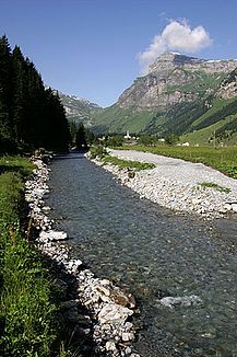
The upper reaches of the Fätschbach near the Wild Boden alpine hut |
||
| Data | ||
| Water code | CH : 754 | |
| location | Switzerland | |
| River system | Rhine | |
| Drain over | Linth → Limmat → Aare → Rhine → North Sea | |
| source | below the Clariden 46 ° 51 '27 " N , 8 ° 52' 29" E |
|
| Source height | 2103 m above sea level M. | |
| muzzle | in the Linth near Linthal Coordinates: 46 ° 54 ′ 29 " N , 8 ° 59 ′ 2" E ; CH1903: 717 725 / 196 362 46 ° 54 '29 " N , 8 ° 59' 2" O |
|
| Mouth height | 714 m above sea level M. | |
| Height difference | 1389 m | |
| Bottom slope | 11% | |
| length | 12.5 km | |
| Catchment area | 42.62 km² | |
| Discharge at the mouth A Eo : 42.62 km² |
MQ Mq |
3 m³ / s 70.4 l / (s km²) |
| Left tributaries | Siwbodenbach, Seiferplanggenbach | |
| Right tributaries | Roten Bach, Stierenbach, Gemsfairenbach | |
| Communities | Spiringen , Glarus South | |
|
Fätschbach in the Urner Boden |
||
The Fätschbach (also just Fätsch ) is an approximately 13 kilometers long left tributary of the Linth in the Swiss cantons of Uri and Glarus , which flows through the Uri soil .
Surname
The river was first mentioned as Varta in a forgery in 1063 . Further mentions are Ferscha 1196, Fersha 1435, Ferscha 1483, Fätscha 1700 and finally Fätschbach in 1705.
geography
course
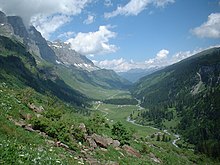
The Fätschbach rises in the Im Griess area at 2103 m above sea level. M. below the Clariden on the watershed of Linth and Reuss . The source is right next to the Griesssee , a glacier lake that was only created in the 1980s when the Clariden glacier melted . It takes up the outflow of this lake and flows through a scree field. After a short run to the north, it falls 200 meters deep into the Chlus ( Klus ), the uppermost part of the valley. Here it takes up the Red Brook and meets the Klausenpassstrasse for the first time .
Shortly afterwards, the stream at Siwloch near Jägerbalm plunges down a valley step in a 30-meter-high waterfall , reaching the upper part of the Urner Boden. It flows from here to the northeast and at the same time takes the most Klausenpass springing Siwbodenbach on. The river now passes through several Alpine settlements, the largest of which are Hergersboden , Urnerboden and Argseeli . It always flows along the right, southern slope of the valley, which is due to the rubble that was loosened by landslides on the Rot Nossen , Signalstock and Jegerstöck .
At the Gubel hill , directly on the cantonal border, it is dammed into a small reservoir. This water is at a pressure tunnel to the water lock , then with a pressure pipe for water power plant Fätschbach conducted in Linthal, which results that partially hardly flows in Glarner underflow water.
After crossing the canton border, the valley narrows and the banks are mostly lined with forest, while the river flows into the Linthal. There it has carved its way deep into the limestone of the fifth formation and forms three waterfalls, of which the middle mountain list is called. He falls into a wooded, narrow and deep gorge, which only opens again directly in front of the mouth.
The Fätschbach crosses under the Klausenstrasse and finally flows southwest of Linthal at the Rubschen shooting range at 714 m above sea level. M. from the left and west into the upper reaches of the Linth , which flows into the Aare as the Limmat in Aargau .
Catchment area
The catchment area of the Fätschbach extends over an area of 42.62 square kilometers. It consists of 38.1% agricultural area, 37.5% unproductive area, 15.3% wooded area, 7.2% glaciers and firn, 1% settlement area and 0.9% water area. The highest point is at 3262 m above sea level. M. a little below the Clariden, the average altitude is 1913 m above sea level. M.
The Fätschbach has a glacial runoff regime . Therefore the river carries little water in the winter months, in February about 0.4 m³ / s on average at the mouth. In the summer months, due to the melting of the glaciers , the level rises sharply and reaches an average of 8.7 m³ / s in June.
In the north is the catchment area of the Muota , in the southwest that of the Chärstelenbach and in the west that of the Schächens .
Berglistüber waterfall
The "Berglistüber" is one of the most beautiful waterfalls in Switzerland. A hiking trail leads visitors behind the waterfall. The rock face consists of approx. 150 million year old Quintner limestone, the so-called Griesstock ceiling. The shale rocks below are about 50 million year old flysch rocks that have been deposited over the basement and have hardly been transported up to now.
The fall is not far from the «Bergli» restaurant on the Klausenpassstrasse.
Use of hydropower
Fätschbach hydropower plant
The high pressure run-of - river power plant is located on the left bank of the Linth, a little below the mouth of the Fätschbach, directly at the village of Linthal. It draws its water from the Fätschbach shortly after the canton border and has been in operation since 1949. It replaces the first hydroelectric power plant, which was commissioned in 1901 and which stood about 200 m above the mouth of the Fätschbach and took the water from the stream at an altitude of 980 m. The water intake of the current power plant is 1,300 m above sea level. It produces 74 GWh annually with two Pelton turbines . In April 2012, the operator Axpo AG announced plans to expand the power plant. Over 20 million Swiss francs should be invested in this. In 2013 she withdrew the project, partly because of falling electricity prices.
Linth-Limmern power plants
The Linth-Limmern power plant takes water from the Fätschbach just below the Griessseelis, which is fed to the Limmernsee via a 12 km long free-flow tunnel . Another water intake is located just above the confluence with the Linth. It feeds the water directly to the Tierfehd pressure tunnel , whose water is processed by two Francis turbines in the Fätschbachwerk building .
Web links
Individual evidence
- ↑ a b c Geoserver of the Swiss Federal Administration ( information )
- ↑ a b c Topographical catchment areas of Swiss waters: sub-catchment areas 2 km². Retrieved September 24, 2017 .
- ^ Albrecht Greule: German book of water names: Etymology of water names and the associated area, settlement and field names . Walter de Gruyter GmbH & Co KG, 2014, p. 800 ( Fätschbach on p. 139 in the Google book search).
- ↑ a b Höfner Volksblatt: Axpo wants to invest over 20 million in Glarnerland ( Memento from September 2, 2016 in the Internet Archive )
- ↑ Berglistüber waterfall, Linthal. (No longer available online.) In: Geopark Sardona. Archived from the original .
- ↑ Berglistüber. In: MySwitzerland.com.
- ↑ A. Sonderegger: The Fätschbachwerk . In: Schweizerische Bauzeitung . May 5, 1951, doi : 10.5169 / seals-58850 .
- ↑ Federal Office for Water Management (Ed.): Statistics on hydropower plants in Switzerland . January 1, 1928, p. 150 .
- ↑ Federal Office for Water Management (Ed.): Statistics on hydropower plants in Switzerland . January 1, 1973, p. 120 .
- ↑ Statistics hydropower in the Linth-Limmat catchment area. Swiss Water Management Association
- ↑ Axpo is not expanding the Fätschbach project in Glarus. Swiss radio and television , April 18, 2013 .


