
Spiringen
| Spiringen | |
|---|---|
 |
|
| State : |
|
| Canton : |
|
| District : | No district division |
| BFS no. : | 1218 |
| Postal code : |
6464 (Spiringen) 8751 (Urnerboden) |
| Coordinates : | 698 360 / 192164 |
| Height : | 923 m above sea level M. |
| Height range : | 724–3266 m above sea level M. |
| Area : | 64.68 km² |
| Residents: | 849 (December 31, 2018) |
| Population density : | 13 inhabitants per km² |
|
Proportion of foreigners : (residents without citizenship ) |
1.5% (December 31, 2,014) |
| Mayor : | Esther Büeler-Arnold |
| Website: | www.spiringen.ch |
 Spiringen |
|
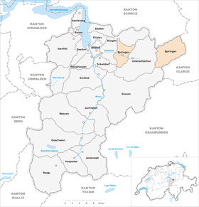
| Location of the municipality | |
  |
|
Spiringen is a municipality in the canton of Uri in Switzerland . Belongs to this community as exclave of Urnerboden .
geography
Spiringen is located on the southern slope of Gamperstock ( 2274 m above sea level ) and Sirtenstock ( 2300 m above sea level ) on the right bank of the Schächen in the Schächental . The hamlet of Witerschwanden ( 774 m above sea level ) to the west of the village and numerous groups of houses, alpine settlements and individual farms belong to the community .
The Urner Boden exclave lies east of the Klausen Pass . It covers an area of 42.04 km² and has only 48 inhabitants (VZ 2000). The Fätschbach flows through Urnerboden and joins the Linth a little south of the village of Linthal . A number of small settlements belong to the Uri soil. Larger ones are Argseeli , Mattenwang and parts of the Urnerboden settlement.
Only 19 ha or 1.4% of the municipality is settlement area. More important is the agricultural area with 2501 ha or a share of 37.5%. The majority of the municipal area is covered by forest and wood (1165 ha or 17.6%) or unproductive area (water and mountains; 3286 ha or 43.5%).
Spiringen borders in the west and north on Bürglen UR , in the east and south on Unterschächen and in the south-west on Schattdorf .
The Urner Boden exclave is bordered by Unterschächen to the west, Muotathal in the canton of Schwyz to the north, the Glarus community Glarus Süd in the Linthal district to the east and south and Silenen to the southwest .
population
| Population development | |
|---|---|
| year | Residents |
| 1850 | 909 |
| 1860 | 836 |
| 1870 | 986 |
| 1900 | 945 |
| 1910 | 1062 |
| 1920 | 912 |
| 1950 | 1050 |
| 1970 | 946 |
| 1990 | 921 |
| 2000 | 963 |
| 2005 | 943 |
The population decreased by 73 people or 8% between 1850 and 1860. After that, it grew strongly by 17.9% until 1870. Since then, there has been an ups and downs with lows of 912 inhabitants in 1920 and a high of 1062 people in 1910. A longer lasting population decline was only observed between 1950 and 1990 (−12.3%).
languages
The population speaks a highly Alemannic dialect. Almost the entire population speaks German as the everyday language. At the last census in 2000, 99.79% said German and 0.21% Italian as their main language.
Religions - denominations
The population used to be fully members of the Roman Catholic Church. The denominational relationships in 2000 still show the original structure. 917 people were Catholic (95.22%). In addition, there were 1.77% Evangelical Reformed Christians and 0.31% non-denominational. 15 people (1.56%) did not provide any information about their creed.
Origin - nationality
Of the 943 residents at the end of 2005, 931 (98.73%) were Swiss citizens. The few immigrants come from Austria and Latin America. At the 2000 census, 961 people (99.79%) were Swiss citizens; one of them had dual citizenship.
age structure
The community has a high proportion of young people. While the proportion of people under the age of twenty makes up a third of the local population, just under 15% are senior citizens (60 years and older).
The last census in 2000 showed the following age structure:
| Age | 0–6 years | 7-15 years | 16-19 years | 20-29 years | 30–44 years | 45–59 years | 60–79 years | 80 years and more |
| number | 110 | 161 | 50 | 121 | 222 | 155 | 116 | 28 |
| proportion of | 11.42% | 16.72% | 5.19% | 12.56% | 23.05% | 16.10% | 12.05% | 2.91% |
politics

legislative branch
The municipal assembly is the legislature. It usually meets twice a year.
executive
The five-person council is the executive . He works part-time. The current mayor is Esther Büeler-Arnold (as of 2017).
economy
In 2005 there were 88 farms with 194 jobs. Industry and trade employed 38 people in 8 workplaces, the service sector in 19 companies 78 people (employment converted to full-time positions). The 2000 census showed 95 agricultural and forestry businesses with 237 employees. The 2001 company census came to 8 industrial and commercial enterprises with 58 and 19 service companies with 83 employees. Of the 441 employed persons in Spingen in 2000, 180 (40.82%) worked in their own community. In total, the place offered 243 jobs, of which 180 (74.07%) were occupied by locals.
Most of the 261 commuters performed their work in other municipalities in the canton of Uri. Including 113 people in Altdorf, 34 in Schattdorf, 33 in Bürglen and 18 in Erstfeld. The most important place of work outside the canton was the municipality of Schwyz . There were also 63 commuters. These came mainly from Unterschächen (19 people), Altdorf (13) and Bürglen UR (12).
Attractions
Town twinning
A partnership with the municipality of Emmen in the canton of Lucerne has existed since 1968 .
Web links
- Official website of the municipality of Spiringen
- Hans Stadler: Spiringen. In: Historical Lexicon of Switzerland .
- Website of the Urnerboden tourist office
Individual evidence
- ↑ Permanent and non-permanent resident population by year, canton, district, municipality, population type and gender (permanent resident population). In: bfs. admin.ch . Federal Statistical Office (FSO), August 31, 2019, accessed on December 22, 2019 .
- ↑ https://www.pxweb.bfs.admin.ch/Selection.aspx?px_language=de&px_db=px-x-0102020000_201&px_tableid=px-x-0102020000_201\px-x-0102020000_201.px&px_type=PX
Altdorf | Andermatt | Attinghausen | Build | Bürglen | Erstfeld | Flüelen | Göschenen | Belt pins | Hospental | Isenthal | Realp | Schattdorf | Seedorf | Seelisberg | Silenen | Sisikon | Spiringen | Undercuts | Water
Canton of Uri | Districts of the canton Uri | Municipalities of the Canton of Uri