
Belt fasteners
| Belt fasteners | |
|---|---|
 |
|
| State : |
|
| Canton : |
|
| District : | No district division |
| BFS no. : | 1209 |
| Postal code : | 6474 Intschi 6482 belt pins |
| Coordinates : | 690 943 / 177 037 |
| Height : | 928 m above sea level M. |
| Height range : | 486–3107 m above sea level M. |
| Area : | 83.31 km² |
| Residents: | 540 (December 31, 2018) |
| Population density : | 6 inhabitants per km² |
|
Proportion of foreigners : (residents without citizenship ) |
8.7% (December 31, 2,014) |
| Mayor : | Karl Walker-Bregar |
| Website: | www.gurtnellen.ch |
.jpg) Belt fasteners |
|
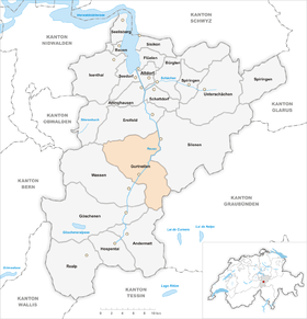
| Location of the municipality | |
  |
|
Gurtnellen is a municipality in the canton of Uri in Switzerland .
geography
Gurtnellen belongs to the Urner Oberland and lies in the upper part of the Urner Reuss Valley . The large community also includes several side valleys. Gorneren is a left side valley of the Reuss Valley and is drained by the Gornerbach . The Fellital lies on the right side of the Reuss and is traversed by the Fellibach. The Fellilücke leads to the Oberalp from Andermatt and the Oberalp Pass .
There are numerous districts and hamlets in the municipality. Gurtnellen village ( 935 m above sea level ) is on the left side of the mountain slope, with the hamlets of Obergurtnellen , Richligen and Ruepelingen above it . 1.5 km south of the village center is on the Reuss Gurtnellen-Wiler ( 741 m above sea level ) with the Gotthard railway station and the village school. The hamlet of Stalden ( 875 m above sea level ) lies between the aforementioned parts of the village . On the right bank of the Reuss, 2 km northeast of the village, is the hamlet of Meitschlingen ( 648 m above sea level ), another one and a half kilometers down the valley the district of Intschi ( 657 m above sea level ). On the left slope of the valley, on a high terrace, lies the Arni settlement , which is divided into Vorderarni and Hinterarni . Between Hinterarni and Torli is at 1370 m above sea level. M. the Arnisee . In the northern section of the municipality, the hamlets of Butzen , Buechen and Rüti are located on the narrow shoreline next to the Reuss .
1.3% of the community area is settlement area. The agricultural area is also small with a share of 11.9%. Most of it is covered by forest and wood (25.1%) or unproductive area (mountains; 61.7%).
Gurtnellen borders in the north on Erstfeld , in the east on the Reuss on Silenen , in the south-east on the Bündner municipality Tujetsch , in the south on Andermatt and Göschenen and in the west on Wassen .

population
| Population development | |
|---|---|
| year | Residents |
| 1837 | 615 |
| 1850 | 675 |
| 1880 | 1541 |
| 1888 | 747 |
| 1900 | 1112 |
| 1920 | 1631 |
| 1930 | 1078 |
| 1941 | 1152 |
| 1970 | 1048 |
| 2000 | 631 |
| 2005 | 640 |
| 2010 | 627 |
| 2016 | 563 |
languages
The local population speaks a highly Alemannic dialect. In the last census in 2000, 97.31% said German, 1.58% Portuguese and 0.48% French were their mother tongue / main language.
Religions - denominations
The population used to be fully members of the Roman Catholic Church. The denominational relationships in 2000 still show the original structures. 575 people (91.13%) were Catholics, 2.22% Evangelical Reformed Christians and 1.74% non-denominational. 27 people (4.28%) did not provide any information about their creed.
Origin - nationality
Of the 643 residents at the end of 2005, 620 (96.88%) were Swiss citizens. The few immigrants came from southern Europe (Portugal and Italy), central Europe (France, Austria, Liechtenstein) and Sri Lanka.
politics


legislative branch
The municipal assembly is the legislature . It meets at least once a year.
executive
The five-person council is the executive . He is part-time working. The current mayor, Karl Walker-Bregar, succeeded Beat Jörg , who has been a member of the Uri government since 2012 (as of 2017).
economy
The community is still strongly characterized by agriculture . In 2000 there were 44 farms employing 107 people. On the hill Grossgand , in the valley Leitschach , with the Intschialp under the Schindlachtal, on Geissberg under the Witenstock, in the valley Gorneren , on the western slope of the Bristen and Fellital Gurtnellen counts numerous Alpine farmland and high pastures.
In 2001 industry and trade had 5 workplaces with 73 employees, the service sector 28 companies and 148 employees.
The municipality of Gurtnellen is regularly dependent on financial support from the canton of Uri or from municipalities in other cantons. In 2002, for example, the city of Zurich supported the community of Gurtnellen with a subsidy of 100,000 francs for the renovation of the district school building. In 2007, Gurtnellen received exceptional support of CHF 500,000 from the canton of Uri for the reorganization of the municipal finances.
Of the 268 gainfully employed people in Gurtnellen in 2000, 143 (53.36%) worked in their own municipality. The 125 commuters do their work in other municipalities in the canton. Including 46 people in Altdorf , 16 in Erstfeld , 14 in Wassen and 12 in Silenen . But there were also 100 commuters. These came mainly from Silenen (28 people), Altdorf (27), Schattdorf (15) and Bürglen UR (10).
tourism
In addition to passers-by on the cantonal road, tourism primarily affects visitors to the valley terrace on Lake Arnisee, hikers and mountaineers. Above Arni is the Sunniggrathütte , below the Krönten massif the Leutschachhütte of the SAC, on the Wichelhorn the Schindlachtalhütte and in the Fellital the Etzlihütte of the SAC.
traffic

The community is accessible for public transport with the lines 1 (Flüelen - Göschenen) and 6 (Gurtnellen-Wiler - Gurtnellen-Dorf) of the Auto AG Uri .
Since the Swiss Federal Railways ceded regional traffic between Erstfeld and Göschenen to Auto AG Uri in 1994, the stations in Intschi and Gurtnellen have no longer been served. As an exception, after a landslide on May 31, 2006, when the A2 motorway and the cantonal road had to be closed, all InterRegio trains and a EuroCity in Gurtnellen stopped during the repair work in order to maintain traffic connections to the town.
Motor vehicles can reach Gurtnellen from the Amsteg exit of the A2 motorway via the old cantonal road ( Hauptstrasse 2 ).
Two cable cars open up the Arni from Amsteg and Intschi.
history
Celto-Roman and Alemannic field and settlement names indicate early settlement. In the early Middle Ages, the Fraumünster Abbey in Zurich owned large amounts of land in the community. From 1688 at the latest, the community was a unit, as it received its own village bailiffs. Because of its location on the Gotthard route, French troops were stationed in the municipality during the times of the Helvetic Republic from 1798 to 1800.
schools
There are kindergartens and primary schools in Gurtnellen-Dorf and Gurtnellen-Wiler. Gurtnellen-Wiler is the school center for the upper level (from the 7th school year) as a teaching location of the Urner Oberland district school (municipalities of Gurtnellen, Wassen and Göschenen).
Attractions

- Church of St. Michael (built 1785) in Gurtnellen village
- Church of St. Joseph in Gurtnellen-Wiler
- St. Anna chapel (built 1661) in Gurtnellen-Wiler
- Arnisee (accessible by cable car)
Others
On May 31, 2006, a rock fall occurred near Gurtnellen that claimed two lives. As a result, a rock head in danger of falling above the A2 near Gurtnellen was blown up at 11 a.m. on June 23.
literature
- Thomas Brunner: The art monuments of the canton Uri, Volume 4: Upper Reuss Valley and Urseren. Edited by the Society for Swiss Art History GSK. Bern 2008 (Art Monuments of Switzerland Volume 114). ISBN 978-3-906131-89-4 . Pp. 133-177.
Web links
- Official website of the municipality of Gurtnellen
- Hans Stadler: Gurtnellen. In: Historical Lexicon of Switzerland .
Individual evidence
- ↑ Permanent and non-permanent resident population by year, canton, district, municipality, population type and gender (permanent resident population). In: bfs. admin.ch . Federal Statistical Office (FSO), August 31, 2019, accessed on December 22, 2019 .
- ↑ https://www.pxweb.bfs.admin.ch/Selection.aspx?px_language=de&px_db=px-x-0102020000_201&px_tableid=px-x-0102020000_201\px-x-0102020000_201.px&px_type=PX
- ↑ Finanzdepartmenet der Stadt Zürich (2002): Annual report, p. 12 ( page no longer available , search in web archives ) Info: The link was automatically marked as defective. Please check the link according to the instructions and then remove this notice.
- ↑ Gurtnellen municipality (January 2008): Ds Gurtnäller Miilirand, p. 9 ( page no longer available , search in web archives ) Info: The link was automatically marked as defective. Please check the link according to the instructions and then remove this notice. (PDF; 314 kB)
- ↑ Rock fall and onset of winter impede the north-south axis. On: swissinfo.ch , May 31, 2006.
- ↑ Bahnen - Arnisee ( page no longer available , search in web archives ) Info: The link was automatically marked as defective. Please check the link according to the instructions and then remove this notice.
Altdorf | Andermatt | Attinghausen | Build | Bürglen | Erstfeld | Flüelen | Göschenen | Belt pins | Hospental | Isenthal | Realp | Schattdorf | Seedorf | Seelisberg | Silenen | Sisikon | Spiringen | Undercuts | Water
Canton of Uri | Districts of the canton Uri | Municipalities of the Canton of Uri