Hospental
| Hospental | |
|---|---|
| State : |
|
| Canton : |
|
| District : | No district division |
| BFS no. : | 1210 |
| Postal code : | 6493 |
| Coordinates : | 686 674 / 163 910 |
| Height : | 1493 m above sea level M. |
| Height range : | 1433-3058 m above sea level M. |
| Area : | 35.17 km² |
| Residents: | 186 (December 31, 2018) |
| Population density : | 5 inhabitants per km² |
|
Proportion of foreigners : (residents without citizenship ) |
11.7% (December 31, 2,014) |
| Mayor : | Beda Regli |
| Website: | www.hospental.ch |
|
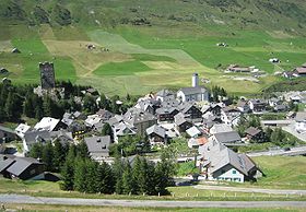
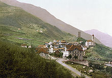
Hospental, view from the old Gotthardstrasse |
|
| Location of the municipality | |
Hospental (in the local dialect : [ ˈoʃpɪˌdɑɫː ]; from Latin hospitale ‹Herberge›) is a municipality in the canton of Uri in Switzerland .
geography
The municipality of Hospental is located in the south of Uris in the Urserental between Andermatt and Realp at the confluence of the Furkareuss and Gotthardreuss rivers . The community consists exclusively of the street village of the same name and the former Walser settlement of Zumdorf , which is currently (2017) inhabited year-round by a family of three.
Only 49 ha or 1.4% of the municipality is settlement area. Of this, five hectares are buildings and 34 hectares are traffic areas. The agricultural area is more extensive with 1131 hectares or a share of 32%. This includes large alpine areas with an area of 946 ha. Only 185 ha are meadow and arable land. In addition, 338 hectares or 10% are covered by forest and wood. Unproductive area comprises most of the municipal area, more precisely 1979 ha or 56%. It concerns almost exclusively areas without vegetation (high mountains) or areas with unproductive vegetation (high alpine vegetation).
Hospental borders Realp in the west, Göschenen in the north, Andermatt in the east and the Ticino municipality of Airolo in the south .
population
The population grew moderately between 1770 and 1870. After that, a strong emigration movement began until 1920. During this period, the number of residents fell by 180 people or 40%. The reason for this was the construction of the railway, which meant that the muleers lost their jobs. In the period between 1920 and 1941 the population increased (1920–1941: + 13%). A standstill phase set in between 1950 and 1970. Another surge in emigration was registered between 1970 and 1990 (1970–1990: −29%), which (with the exception of an interim high in 2005) has continued to this day.
languages
The population speaks a highly Alemannic dialect. Almost the entire population speaks German as the everyday language. In the last census in 2000, 97% said German, 1.5% Romansh and 0.5% Italian as their main language.
Religions - denominations
The population used to be fully members of the Roman Catholic Church. The denominational relationships in 2000 still show the original structure. 195 people were Catholic (94.66%). In addition, there were 4% Evangelical Reformed Christians and 0.49% non-denominational.
Origin - nationality
Of the 220 residents at the end of 2005, 215 (98%) were Swiss citizens. The immigrants came from Central Europe (Austria), Southern Europe (Italy and Portugal), Serbia-Montenegro and Sri Lanka. At the 2000 census, 203 people (98%) were Swiss citizens; five of them had dual citizenship.
age structure
The community has a high proportion of older residents. In 2002, 20% of the population was under 20 years of age and 30% over 60.
| Age | 0–6 years | 7-15 years | 16-19 years | 20-29 years | 30–44 years | 45–59 years | 60–79 years | ≥80 years |
|---|---|---|---|---|---|---|---|---|
| number | 19th | 14th | 8th | 24 | 44 | 36 | 50 | 11 |
| proportion of | 9.22% | 6.80% | 3.88% | 11.65% | 21.36% | 17.48% | 24.27% | 5.34% |
| year | 1799 | 1850 | 1870 | 1880 | 1888 | 1900 | 1920 | 1941 | 1950 | 1970 | 1980 | 1990 | 2000 | 2005 | 2010 | 2012 | 2014 | 2016 |
|---|---|---|---|---|---|---|---|---|---|---|---|---|---|---|---|---|---|---|
| Residents | 368 | 424 | 444 | 404 | 330 | 290 | 264 | 298 | 282 | 285 | 242 | 202 | 206 | 220 | 177 | 216 | 196 | 188 |
politics
Legislature
The municipal assembly forms the legislature . It usually meets twice a year.
Executive
The five-member municipal council forms the executive . He works part-time. The current mayor is Beda Regli (as of 2017).
economy
In 2005 there were 8 farms offering 19 jobs. Industry and trade employed 4 people in 2 workplaces, the service sector in 13 companies 30 people (employment converted to full-time positions). The 2000 census showed 9 agricultural and forestry businesses with 26 employees. The 2001 company census came to 3 industrial and commercial enterprises with 11 and 15 service companies with 39 employees. Of the 98 employed people in Hospental in 2000, 36 (36.73%) worked in their own community. In total, the place offered work to 49 people, of whom 36 (73.47%) were locals.
On the southern slope of the valley, above the village, a lenticular serpentinite deposit is being mined by a quarry. It is flanked by soapstone zones and is entirely enclosed by the gneiss of the Gotthard massif . The dark green to blue-green serpentinite with point-like and partly ophiolithic structure is a traditional decorative stone in Switzerland. It is still used today for simple to artistically demanding work.
Most commuters work in Andermatt, some commuters come mainly from Andermatt.
traffic
Postbuses and regional trains of the Matterhorn-Gotthard-Bahn (MGB) on the route from Andermatt to Brig stop in Hospental . In addition, the main roads number 2 ( Gotthardpassstrasse ) and 19 run through Hospental.
history
Finds in the 1990s near Rossplatten at 2170 m above sea level. M. indicate a late Neolithic , Early Bronze Age settlement of this Alpine region.
The village of Hospental was formed around a hostel founded by the Disentis monastery in the 9th or 10th century . The hamlet of Zumdorf was founded in the 12th century by Walsers who immigrated to the area previously inhabited exclusively by Romans . In 1669 the village burned down. Due to the expansion of the Alpine passes, the coach and hotel business flourished, although this only lasted until the Gotthard Railway was completed in 1882. Edging , hospitality, crystal trade and pay service supplemented the widespread agriculture. Until 1886 Hospental belonged to the parish of Andermatt, after which an independent parish was created. In 1888, Hospental emerged as an independent political municipality from the Urseren valley community . Between 1920 and 1944 there were various plans to build an Urseren power plant . The project failed, among other things, because of the resistance of the village to resettlement. In 1926 the station of the Furka-Oberalp-Bahn (FO) (today Matterhorn-Gotthard-Bahn MGB) and in 1960 a ski lift on the Winterhorn were opened to promote tourism . Because of the architectural importance of the site, a bypass was opened in 1983.
Attractions
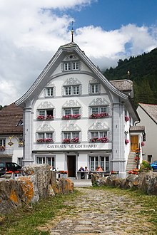
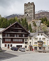
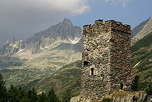
The most striking building is the tower of the Lords of Hospental , built in the first half of the 13th century. It served as a residential tower, but has not been inhabited since the 15th century. The baroque parish church Maria Himmelfahrt (1706–1708) with its magnificent altars is also worth seeing. In the center of the village there are numerous wooden houses built in block construction, which were built after the village fire of 1669. The chapel and the benefice house of St. Karl are on the edge of the village. The baroque chapel from 1721 was renovated in 1907 in a neo-baroque style. The St. Nikolaus chapel in the hamlet of Zumdorf originally dates from 1591 and was renovated in 1758 in the Baroque style.
Personalities
- Adolfo Müller-Ury (born March 29, 1862 in Airolo , † July 8, 1947 in New York City ) (town Hospental), painter, son of Alois and Genovefa Müller-Lombardi
- Antoinette Meyer (born June 19, 1920 in Hospental; † July 19, 2010 in Thun; married Molitor-Meyer), ski racer, silver medalist at the 1948 Winter Olympics
literature
- Thomas Brunner: Hospental on the Gotthard Pass. (Swiss Art Guide, Volume 739, Series 74). Ed. Society for Swiss Art History GSK. Bern 2003, ISBN 3-85782-739-4 .
- Thomas Brunner: The art monuments of the canton Uri, Volume 4: Upper Reuss Valley and Urseren. (Art Monuments of Switzerland, Volume 114). Edited by the Society for Swiss Art History GSK. Bern 2008, ISBN 978-3-906131-89-4 , pp. 366-415.
Web links
- Hospental on the ETHorama platform
- Official website of the municipality of Hospental
- Hans Stadler: Hospental. In: Historical Lexicon of Switzerland .
- Federal inventory ISOS: Hospental
Individual evidence
- ↑ Permanent and non-permanent resident population by year, canton, district, municipality, population type and gender (permanent resident population). In: bfs. admin.ch . Federal Statistical Office (FSO), August 31, 2019, accessed on December 22, 2019 .
- ↑ pxweb.bfs.admin.ch
- ↑ Gabrielle Schmid / Andres Kristol: Hospental UR (Uri) in: Dictionnaire toponymique des communes suisses - Lexicon of Swiss community names - Dizionario toponomastico dei comuni svizzeri (DTS | LSG). Center de dialectologie, Université de Neuchâtel, Verlag Huber, Frauenfeld / Stuttgart / Vienna 2005, ISBN 3-7193-1308-5 and Éditions Payot, Lausanne 2005, ISBN 2-601-03336-3 , p. 455.
- ↑ «Game for your country» - round 7. Video in: SRF 1 from September 30, 2017 from 2:12:53.
- ↑ F. de Quervain: The usable rocks of Switzerland. Kummerly & Frey, Bern 1969.
- ↑ Traces of a cultural landscape, Neujahrsblatt Uri 2014 ( Memento of the original from March 4, 2016 in the Internet Archive ) Info: The archive link was inserted automatically and has not yet been checked. Please check the original and archive link according to the instructions and then remove this notice.
- ^ Archeology Switzerland: Sensations as a result of melting glaciers - people in the Alps
- ^ Thomas Brunner: Neu-Andermatt, Neu-Hospental. Planned home for the Ursern reservoir project in 1920 . In: Art + Architecture in Switzerland . tape 54 , 2003, p. 6–12 , doi : 10.5169 / seals-394251 .
- ↑ Hans Danioth: The large Ursern power plant project as reflected in the times: February 19, 1946: riot or popular uprising? In: Historischer Verein Uri (ed.): Historisches Neujahrsblatt . tape 100 , 2009, doi : 10.5169 / seals-405872 .
- ^ Tapan Bhattacharya: Adolfo Müller-Ury. In: Historical Lexicon of Switzerland .
- ↑ Adolfo Müller-Ury on ti.ch/can/oltreconfiniti/
- ^ Rolf E. Keller: Adolfo Müller-Ury. In: Sikart (status: 2009) , accessed January 23, 2016.
