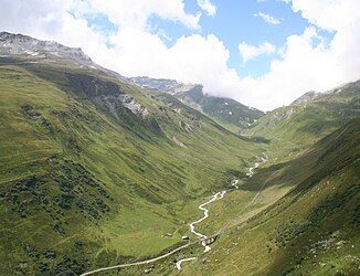
Furkareuss
|
Furkareuss upper course name: Blaubergbach |
||
|
Furkareuss valley to the west and Furka pass |
||
| Data | ||
| Water code | CH : 38 | |
| location | Canton of Uri ; Switzerland | |
| River system | Rhine | |
| Drain over | Reuss → Aare → Rhine → North Sea | |
| source | south of the Furka Pass in the Upper Schwärziseeli 46 ° 33 ′ 44 ″ N , 8 ° 25 ′ 49 ″ E |
|
| Source height | 2640 m above sea level M. | |
| Name change | at the confluence of the Gotthardreuss at Hospental zu Reuss Coordinates: 46 ° 35 ′ 16 ″ N , 8 ° 29 ′ 41 ″ E ; CH1903: 680 941 / 160 164 46 ° 35 '16 " N , 8 ° 29' 41" O |
|
| Mouth height | 1573 m above sea level M. | |
| Height difference | 1067 m | |
| Bottom slope | 69 ‰ | |
| length | 15.5 km | |
| Catchment area | 92.01 km² | |
| Discharge at the mouth of the A Eo : 92.01 km² |
MQ Mq |
4.61 m³ / s 50.1 l / (s km²) |
| Right tributaries | Steffentalbach, Witenwasserenreuss , Gotthardreuss | |
The Furkareuss is the upper reaches of the Reuss in the Swiss canton of Uri . At Hospental it unites with the smaller Gotthardreuss and from then on is only called Reuss.
course
The Furkareuss rises as Blaubergbach in the Oberen Schwärziseeli above the Furka Pass . It then flows through the Mittlere Schwärziseeli, falls steeply down into the valley and meets the Furka mountain route near the Furka train station (2163 m above sea level) and is now called Furkareuss. After the confluence of the Sidelen and Tiefenbach (both from the left) the Witenwasserenreuss (its largest tributary) joins from the right . In the valley floor of the Urserental it passes the villages Realp and Zumdorf and flows together with the Gotthardreuss at Hospental to form the Reuss. The Furkareuss has covered a distance of around 16 kilometers to this point, the Gotthardreuss only around nine kilometers.
bridges
On its way, the Furkareuss is spanned by 24 bridges, ie ten road, eight pedestrian and six railway bridges.
Two historical stone arch bridges cross the river, namely the Alte Furkastrasse bridge (built in the 1860s) in Realp and the Tennlen bridge (built presumably from the 16th to 17th centuries) in Hospental.
Two striking railway viaducts are worth mentioning: the Steinstafel viaduct (1926) on the Furka mountain route in Realp-Tiefenbach and the Richleren viaduct (1913) on the Matterhorn-Gotthard railway in Hospental.
Web links
- Furkareuss on the ETHorama platform
Individual evidence
- ↑ a b c d Geoserver of the Swiss Federal Administration ( information )
- ↑ a b Topographical catchment areas of Swiss waters: sub-catchment areas 2 km². Retrieved June 22, 2019 .
