
Attinghausen
| Attinghausen | |
|---|---|
 |
|
| State : |
|
| Canton : |
|
| District : | No district division |
| BFS no. : | 1203 |
| Postal code : | 6468 |
| Coordinates : | 690 694 / 190715 |
| Height : | 468 m above sea level M. |
| Height range : | 441–3193 m above sea level M. |
| Area : | 46.89 km² |
| Residents: | 1725 (December 31, 2018) |
| Population density : | 37 inhabitants per km² |
|
Proportion of foreigners : (residents without citizenship ) |
6.1% (December 31, 2,014) |
| Mayor : | Anita Zurfluh |
| Website: | www.attinghausen.ch |
 Attinghausen |
|
| Location of the municipality | |
  |
|
Attinghausen is a municipality in the canton of Uri in Switzerland .
geography
Attinghausen is located on the left bank of the Reuss at around 469 meters above sea level. The municipality is bordered in the north by the Palanggenbach in Gitschental and in the south by the Angibach in the Alptal Waldnacht and the Bockibach , which flows through the narrow Bockitobel. In the west, beyond the Surenen Pass, the large alpine farming area of Surenen belongs to near the village of Engelberg zu Attinghausen. The Surenental lies between the mountain ranges of the Wissigstock in the north and the Schlossberg in the south.
80 hectares or 1.7% of the municipality are settlement areas. Of this, 45 hectares are building or industrial areas and 15 hectares are traffic areas. More important is the agricultural area with 1651 ha or a share of 35.3%. This includes 1,417 hectares of alpine areas . 820 hectares or 17.5% of the municipal area are covered by forest and wood. Unproductive area covers large areas of the municipality, namely 2131 ha or 45.5%. These are almost exclusively areas with no vegetation in the high mountains or unproductive vegetation.
Attinghausen borders in the west on the Obwalden community Engelberg , in the north on Isenthal and Seedorf UR , in the east on Altdorf UR , Bürglen UR , Schattdorf and Erstfeld and in the south on Wassen .
population
The population was 530 people in 1860. This was followed by a population decline until 1888 (1860–1888: −51 people or −9.6%). This was followed by a decade-long growth phase until 1960. During this time, the population increased two and a half times (1888–1960: +148.4%). After a small slump in the 1960s, the town had the same number of residents in 1980 as in 1960. Since then, strong growth has set in (1980–2005: +323 inhabitants or +27.0%).
| Population development | |
|---|---|
| year | Residents |
| 1860 | 530 |
| 1888 | 479 |
| 1900 | 528 |
| 1920 | 618 |
| 1941 | 890 |
| 1960 | 1190 |
| 1970 | 1141 |
| 1980 | 1197 |
| 1990 | 1319 |
| 2000 | 1487 |
| 2005 | 1520 |
languages
The population speaks a highly Alemannic dialect. Almost the entire population speaks German as the everyday language. In the last census in 2000, 96.64% said German, 0.64% Serbo-Croatian and 0.47% Dutch were the main languages.
Religions - denominations
The population used to be fully members of the Roman Catholic Church. The denominational relationships in 2000 still show the original structure. 1384 people were Catholic (93.07%). In addition, there were 3.30% Evangelical Reformed Christians and 0.87% Orthodox Christians and non-denominational Christians. 8 people (0.54%) did not provide any information on their creed.
Origin - nationality
Of the 1520 residents at the end of 2005, 1481 (97.43%) were Swiss citizens. The majority of the immigrants come from southern Europe (Portugal and Italy), the former Yugoslavia and Sri Lanka. At the 2000 census, 1,438 people (96.70%) were Swiss citizens; 22 of them had dual citizenship.
Dominant genders and names in Attinghausen are: Arnold, Christen, Dittli, Furrer, Gisler, Herger, Imholz, Kempf, Stadler, Wyrsch, Zgraggen and Zurfluh.
age structure
The church has a high percentage of younger people. While the proportion of people under the age of twenty makes up 27.24% of the local population, just 17.2% are senior citizens (60 years and older). This is a consequence of the immigration of young people from the Oberland and abroad in the period after 1980.
The last census in 2000 showed the following age structure:
| Age | 0–6 years | 7-15 years | 16-19 years | 20-29 years | 30–44 years | 45–59 years | 60–79 years | 80 years and more |
| number | 146 | 198 | 61 | 221 | 371 | 234 | 218 | 38 |
| proportion of | 9.82% | 13.32% | 4.10% | 14.86% | 24.95% | 15.74% | 14.66% | 2.56% |
politics
legislative branch
The municipal assembly forms the legislature. It usually meets twice a year.
executive
The seven-member municipal council forms the executive . He works part-time. The current mayor is Karl Imholz (as of 2017).
economy
In 2005 there were 44 farms offering 102 jobs. Industry and trade employed 80 people in 10 workplaces, the service sector in 19 companies 153 people (employment converted to full-time positions). The 2000 census showed 47 agricultural and forestry businesses with 119 employees. The 2001 company census came to 11 industrial and commercial enterprises with 75 and 28 service companies with 171 employees. Of the 745 employed people of Attinghausen in 2000, only 177 (23.76%) worked in their own community. In total, the place offered jobs to 296 people, of whom 177 (59.80%) were locals.
Most of the 568 commuters do their work in other communities in the canton of Uri. Including 249 people in Altdorf, 74 in Schattdorf, 30 in Flüelen, 28 in Bürglen, 26 in Erstfeld and 23 in Seedorf. The municipality of Schwyz (with 30 people) is the only significant work place outside the canton. There were 119 commuters. These came mainly from Altdorf (27 people), Schattdorf (23), Seedorf (16) and Bürglen (13).
Attractions
The Attinghausen castle ruins are in Attinghausen . This was first mentioned as the seat of the noble von Attinghausen in 1240 and burned down in 1365 - probably by the Uri farmers.
Personalities
- Josef Konrad Scheuber (1905–1990), clergyman, youth and folk writer and founder of the Tell Museum in Bürglen
- Hans Zurfluh (* 1927), farmer and politician
- Josef Dittli (* 1957), politician
photos

Parish church
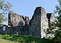
Castle ruins
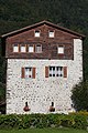
Schweinsberg residential tower

Reuss


Web links
- Official website of the community of Attinghausen
- Hans Stadler: Attinghausen. In: Historical Lexicon of Switzerland .
Individual evidence
- ↑ Permanent and non-permanent resident population by year, canton, district, municipality, population type and gender (permanent resident population). In: bfs. admin.ch . Federal Statistical Office (FSO), August 31, 2019, accessed on December 22, 2019 .
- ↑ https://www.pxweb.bfs.admin.ch/Selection.aspx?px_language=de&px_db=px-x-0102020000_201&px_tableid=px-x-0102020000_201\px-x-0102020000_201.px&px_type=PX
- ^ Charles Knapp, Maurice Borel, Victor Attinger, Heinrich Brunner, Société neuchâteloise de geographie (editor): Geographical Lexicon of Switzerland . Volume 1: Aa - Emmengruppe . Verlag Gebrüder Attinger, Neuenburg 1902, p. 99, keyword Attinghausen ( scan of the lexicon page ).
- ^ Hans Stadler : Hans Zurfluh. In: Historical Lexicon of Switzerland . February 24, 2014 , accessed September 21, 2019 .
Altdorf | Andermatt | Attinghausen | Build | Bürglen | Erstfeld | Flüelen | Göschenen | Belt pins | Hospental | Isenthal | Realp | Schattdorf | Seedorf | Seelisberg | Silenen | Sisikon | Spiringen | Undercuts | Water
Canton of Uri | Districts of the canton Uri | Municipalities of the Canton of Uri