
Flüelen
| Flüelen | |
|---|---|
 |
|
| State : |
|
| Canton : |
|
| District : | No district division |
| BFS no. : | 1207 |
| Postal code : | 6454 |
| UN / LOCODE : | CH FLN |
| Coordinates : | 690 311 / 195002 |
| Height : | 435 m above sea level M. |
| Height range : | 429–2220 m above sea level M. |
| Area : | 12.39 km² |
| Residents: | 1972 (December 31, 2018) |
| Population density : | 159 inhabitants per km² |
|
Proportion of foreigners : (residents without citizenship ) |
13.7% (December 31, 2,017) |
| Mayor : | Remo Baumann |
| Website: | www.flueelen.ch |
 Flüelen as seen from Axenstrasse (2013) |
|
| Location of the municipality | |
  |
|
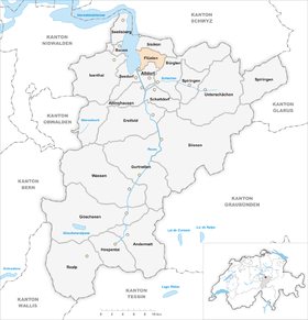
Flüelen ( Italian Fiora ) is a municipality in the canton of Uri in Switzerland . Neighboring communities are Seedorf in the southwest , Sisikon in the north, Bürglen in the east and Altdorf in the south .
geography
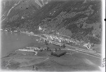
Flüelen is located at the southern end of Lake Uri , an arm of Lake Lucerne , between the confluence of the Reuss and the Rophaien mountain range east of the lake. In the lower part of the slope of the Rophaien the nearly 400 meter high rock face of the protruding axes up from the lake. Up until the 19th century, it was an insurmountable obstacle to traffic between Brunnen and the canton of Uri. In the northeast, the municipal boundary roughly follows the watershed with the striking mountains Hüenderegg, Hagelstock, Siwfass and Diepen, which is 2222 m high. ü. M. represents the highest point in the municipality. The small lake Gross Flesch is located at the pass from the Gruontal to the Selezalp above the village of Bürglen. The steep valley of the Gruonbach from the high Alp Schön Chulm to the Urnersee makes up the largest part of the municipality area. The creek bed has been built with numerous dams and torrent barriers since 1884 to protect the part of the Usserdorf settlement, which spreads over the original rubble fan of the creek, and the important traffic routes .
Like the smaller brooks that flow from the mountain slopes to Lake Lucerne near Flüelen, the Gruonbach represents a considerable risk of flooding and debris flows after heavy rainfall. like the flood in 2005 , when the village center and the entire commercial area of Flüelen were flooded on the plain. After several floods that had devastated the valley floor near Altdorf and Flüelen in the first half of the 19th century, the Reuss river bed was straightened and secured with dams from 1850 to 1863. In the 20th century, however, the Reuss broke through the flood dams several times. The flood disaster of 1987 damaged many houses and the railway systems and flooded the motorway. After this event, the canton of Uri enlarged the channel in the Reuss Canal and built additional protective systems and a dam half a kilometer east of the Reuss to Lake Uri.
The forest on the steep mountain slope above the village center of Flüelen was declared a forest in 1382 . Forestry classifies it as an "extreme rockfall protection forest" because of its topography. The Gruonwald belongs to the corporation communities of Flüelen, Altdorf and Bürglen jointly according to a state community resolution of 1675.
From the alluvial plain of the Reuss on Lake Lucerne, the right side of the Reuss delta with its largely marshy ground belongs to Flüelen. The large gravel deposits on the edge of the delta have been exploited since the late 19th century by the excavator company Arnold & Co. AG, which has been using excavators since 1897. Since the Reuss Delta Law in Uri came into effect in 1986, the exploitation of gravel has been coordinated with the landscape protection in the Reuss Delta area. Around 1.8 million tons of rock of the excavated material from the Gotthard Base Tunnel were used for embankments in the lake in front of the Reuss delta. Three new islands ("Neptune Islands") have been created.
The village settlement lies in a narrow strip of land on the lake and consists of the merged districts of Oberdorf, Dorf and Usserdorf. The commercial quarter of Flüelen is located between the railway line and the Reuss.
Only 76 hectares or 6% of the municipality is settlement area. Of this, 28 hectares are buildings, 10 hectares are industrial areas and 30 hectares are used for traffic. The agricultural area is more extensive with 273 ha or a share of 22%. These include alpine areas with an area of 186 ha east of the village below the Eggberge , a mountain range northeast of Altdorf. Another 85 hectares are other meadow and arable land. More than half of the municipal area, namely 684 ha or 55%, is covered by forest and wood. Unproductive area on 209 ha or 17% of the municipal area consists almost exclusively of areas with little vegetation in the high mountains.
population
| Population development | |||
|---|---|---|---|
| year | Residents | year | Residents |
| 1685 | 337 | 1930 | 1170 |
| 1743 | 372 | 1941 | 1608 |
| 1799 | 469 | 1970 | 1731 |
| 1850 | 600 | 1990 | 1695 |
| 1860 | 660 | 2000 | 1787 |
| 1880 | 1420 | 2005 | 1874 |
| 1888 | 730 | 2010 | 1950 |
| 1920 | 1185 | ||
Due to the importance of Flüelen as a trading center on the Gotthard route , the number of inhabitants was known early on. The place grew relatively slowly between 1685 and 1743 and then a little stronger until 1799. Also in the phase up to 1860 the number of residents increased only slowly. An outstanding year was 1880, when the population was significantly higher than before due to the presence of construction workers on the Gotthard Railway. It therefore sank again significantly by 1888. Between 1888 and 1920 there was then a permanent population increase of 62%, as a result of the good transport connections ( Axenstrasse and Gotthard Railway). This was followed by a decade of stagnation. In the 1930s, the population grew again by 37%. After a steady growth spurt until 1970, there was a small decline in the population until 1990. Growth remained modest in the half century from 1941 to 1990. Increased growth began in 1990 and continues to this day.
The population speaks a highly Alemannic dialect. Almost the entire population speaks German as the everyday language. At the last census in 2000, 94% said German, 2% Italian and around 2% Albanian as their main language.
The population used to be fully members of the Roman Catholic Church. The denominational relationships in 2000 still show the original structure. 1562 people were Catholic (87%). In addition, there were 6% Evangelical Reformed Christians, 1.4% Muslims and 2.80% non-denominational. 28 people did not provide any information about their creed.
Of the 1874 residents at the end of 2005, 1692 (90%) were Swiss citizens. The majority of the immigrants come from Central Europe (Germany), Southern Europe (Italy) and the former Yugoslavia (Serbia-Montenegro). At the 2000 census, 1601 people (90%) were Swiss citizens; 57 of them had dual citizenship.
The community has a high proportion of middle-aged people (30–59 years; 41%). The proportion of people under the age of twenty of 22% of the local population almost corresponds to the proportion of senior citizens (60 years and older; 22%).
The last census in 2000 showed the following age structure:
| Age | 0–6 years | 7-15 years | 16-19 years | 20-29 years | 30–44 years | 45–59 years | 60–79 years | 80 years and more |
| number | 152 | 187 | 59 | 262 | 430 | 305 | 296 | 96 |
| proportion of | 8.51% | 10.46% | 3.30% | 14.66% | 24.06% | 17.07% | 16.56% | 5.37% |
politics
legislative branch
The municipal assembly forms the legislature. It usually meets twice a year.
executive
The seven-member municipal council forms the executive . He works part-time. The current mayor is Simon Arnold (as of 2017).
economy
Structure and development
In 2005 there were 16 farms offering 44 jobs. Industry and trade employed 256 people in 19 workplaces, the service sector in 56 companies 387 people (employment converted to full-time positions). The 2000 census showed 20 agricultural and forestry companies with 51 employees. The 2001 census came to 21 industrial and commercial enterprises with 220 and 70 service companies with 418 employees. The municipality, which used to be dominated by agriculture, now has a high proportion of industrial workers and tradespeople. Of the 909 employed people in Flüelen in 2000, 293 (32.23%) worked in their own community. In total, the place offered work for 681 people, of whom 293 (43.02%) were locals.
Most of the 616 commuters work in other municipalities in the canton of Uri. Including 281 people in Altdorf, 56 in Schattdorf, 29 in Bürglen, 27 in Erstfeld and 18 in Seedorf. Important places of work outside the canton are the municipalities of Schwyz (24 people) and Ingenbohl (12) in the canton of Schwyz , the city of Lucerne (26) and Emmen (10) in the canton of Lucerne and the city of Zug (12) in the canton of Zug . The 388 commuters came mainly from Altdorf (98 people), Seedorf (49), Schattdorf (45), Erstfeld and Bürglen (40 each), Attinghausen (30) and Silenen (20).
In the 2012 cantonal development plan of the canton of Uri, the municipality of Flüelen is identified as a development focus for the areas of housing, services and tourism.
Industry
Arnold & Co. Sand- und Kieswerke AG operates the mining of gravel and sand in front of the Reuss estuary and transports traffic on Lake Lucerne from its factory premises near the port of Flüelen .
traffic
train

The Gotthard Railway runs through Flüelen, where the Flüelen train station was built on the lake .
Street
The community is on two important roads. The Axenstrasse , opened in 1865, runs through the village, with the Flüelertunnel being a bypass built in 2005 . South of the municipality, the Axenstrasse is connected as the A4 motorway to the A2 at the Altdorf Nord exit . The main road 2 runs on the Axenstrasse along with the A4, but then leads through the village. The A4 and H2 then cross at the Flüeler roundabout , from where the H2 continues to Altdorf .
The Altdorf – Flüelen tram existed from 1906 to 1951 . Today the community is served by one bus and three PostBus lines from Auto AG Uri .
additional
At the port of Flüelen there is an important ship station in the timetable of the shipping company for Lake Lucerne .
The Swiss Path, established in 1991, leads in its middle part along Lake Lucerne through Flüelen. In this section with a new wooden bridge over the Reuss are the routes of the cantons of Baselland, Schaffhausen, both Appenzell, Sankt Gallen and Graubünden. The route between Flüelen and Sisikon is partly on the route of the old Axenstrasse.
Two cable cars lead from Usserdorf to the high-altitude hamlets of Gibel and Ober Axen.
The Eggberge cable car, built south of the village in the Altdorf area, connects the Altdorf Alpine settlement of Eggbergen and the distant Alps of Flüelen. The demanding Wildheuer hiking trail leads from the Eggbergen mountain station through the high pastures on the Rophaien to the Oberaxen station.
tourism


Flüelen has long been an important stage on the Gotthard route. A hotel and a campsite offer accommodation options.
In addition to the “Swiss Path”, there are also hiking trails above the Gruontal near Flüelen. The wild hay path from the Eggbergen over the high-altitude hay meadows under the Rophaien to Oberaxen is particularly well known .
Infrastructure
On the mountain slope above the village, three large high-voltage lines lead from the Alps to the Swiss Plateau. In 1945 the Atel electricity company (now Alpiq Holding ) built a high-voltage line from the Amsteg power plant over the Axen to Immensee. Another line belongs to the Swiss Federal Railways.
The municipality of Flüelen is connected to the Altdorf wastewater treatment plant for urban drainage.
history
In the Middle Ages there was a customs post of the German Empire at the Umschlagplatz on the lake. The imperial tariff for goods transported over the Gotthard is mentioned for the first time in 1313. Around 1400 customs came to the country of Uri. In 1383 a trade association is mentioned in Flüelen, in 1374 a shipping company.
Brick production was first documented in Flüelen in 1560. In 1576 Ritter Walter von Roll took over the brickworks. The first known brickworks was located in Ausserdorf on the area of the property still known today as the "brick house". The brickworks and building materials trading company Bernhard Ziegler & Söhne AG has been part of the building materials group HGC since 2015 .
Until the middle of the 17th century, Flüelen was part of Altdorf UR . Since then the community has been independent.
In 1837 the regular traffic of steamships began on Lake Lucerne.
When the railway was built on the lakeshore around 1870, most of the old port facility was filled in and the appearance of the village was greatly changed.
In 2015 the village celebrated its 750th anniversary.
Attractions
The “Föhnwacht”, one of the most beautiful and well-known murals by the Uri painter Heinrich Danioth , can be seen in the waiting room of the train station . The new station has existed since 1945 and was an avant-garde building at the time .
Between the train station and the ship station stands the sculpture Swearing Hands ( Rütlischwur ), which the artist Werner Witschi designed for Expo 64 and which the city of Lausanne handed over to the canton of Uri in 1965 .
Not far from the train station is Rudenz Castle with the publicly accessible castle park.
A permanent exhibition has been set up in the former church since March 2008, in which mountain crystals from the region, including the extraordinary find from 2006, are shown. In 2015 there was a special exhibition for the anniversary of the community.
The old church should have been demolished after the exsecution in 1912 and served as a brush manufacturing hall during the First World War. Over the years it has been used by various clubs as a gym or as a troop shelter and for community meetings. In 2010 it was completely renovated.
The new parish church Herz Jesu was built in 1912.
photos
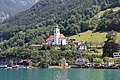
Parish church Herz Jesu, Flüelen

Hist. House on a slope in Flüelen

Flüelen shipyard, 1817
Protective structures between Axeneck and Sulzegg

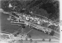
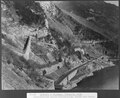
Gruonbach near Flüelen, dams to protect the Gotthard Railway, 1914


Personalities
- Joachim Leonz Eder (1772–1848), lawyer and politician
- Heinrich Danioth (1896–1953), artist
- Alfred Schaller (1908–1985), politician (FDP)
- Franz Steinegger (* 1943), lawyer and politician (FDP)
- Miro Muheim (* 1998), soccer player
literature
- Helmi Gasser : The art monuments of the canton Uri. Volume 2: The lakeside communities (= Swiss art monuments. Volume 78). Edited by the Society for Swiss Art History GSK. Bern 1986, ISBN 3-7643-1811-2 , pp. 61-138.
- Alfons Müller-Marzohl: Flüelen UR, the village and its churches (= Swiss Art Guide. No. 484). Ed. Society for Swiss Art History GSK. Bern 1991, ISBN 978-3-85782-484-5 .
- Robert Müller: Flüelen, its history and development. Altdorf 1912.
- Josef Gwerder: The history of shipping on Lake Lucerne. Lucerne 1987.
Web links
- Official website of the municipality of Flüelen
- Hans Stadler: Flüelen. In: Historical Lexicon of Switzerland .
Individual evidence
- ↑ Permanent and non-permanent resident population by year, canton, district, municipality, population type and gender (permanent resident population). In: bfs. admin.ch . Federal Statistical Office (FSO), August 31, 2019, accessed on December 22, 2019 .
- ↑ Community portraits . Federal Statistical Office , accessed on April 11, 2019 .
- ↑ Kafur report HW 2005, part B. (PDF; 2.2 MB) Canton Uri, accessed on April 11, 2019 .
- ↑ Report Urner Talboden.
- ↑ Report mountain forest maintenance Flüelen.
- ^ Corporation of the Bürgergemeinde Flüelen: Gruonwald.
- ↑ Gravel extraction on the Reuss delta.
- ^ Website of the Reuss Delta project.
- ↑ Christoph Zurfluh, Edi Schilter, Hans Paul Gemperli: Neuland. The islands in Lake Uri. Altdorf 2006.
- ↑ Planning report Flüelen 2016 ( Memento from August 6, 2016 in the Internet Archive )
- ^ Website of the company Arnold & Co.
- ↑ Less noise in Flüelen and bathing fun. In: Neue Zürcher Zeitung . June 11, 2005, accessed April 11, 2019 .
- ↑ Flüelen - Oberaxen cable car. oberaxen.ch, accessed on April 11, 2019 .
- ^ Eggberge: cable car. eggberge.ch, accessed on April 11, 2019 .
- ↑ a b Wild hay path: Flüelen / Eggberge - Oberaxen. wandersite.ch, accessed on April 11, 2019 .
- ↑ flueelen.ch: Economic history, brick production , accessed on January 2, 2016
- ↑ Steam boat trip near Flüelen.
- ↑ The lake gives, the lake takes , NZZ, July 18, 2015.
- ↑ Plastic Swearing Hands.
- ↑ Crystal exhibition
- ^ Extraordinary exhibition in the old church in Flüelen , SRF, July 8, 2015.
- ↑ Information from the community on the old church
Altdorf | Andermatt | Attinghausen | Build | Bürglen | Erstfeld | Flüelen | Göschenen | Belt pins | Hospental | Isenthal | Realp | Schattdorf | Seedorf | Seelisberg | Silenen | Sisikon | Spiringen | Undercuts | Water
Canton of Uri | Districts of the canton Uri | Municipalities of the Canton of Uri