
Schattdorf
| Schattdorf | |
|---|---|
 |
|
| State : |
|
| Canton : |
|
| District : | No district division |
| BFS no. : | 1213 |
| Postal code : |
6467 (Schattdorf) 6469 (Haldi near Schattdorf) |
| Coordinates : | 692 783 / 191241 |
| Height : | 481 m above sea level M. |
| Height range : | 448–2497 m above sea level M. |
| Area : | 16.33 km² |
| Residents: | 5424 (December 31, 2018) |
| Population density : | 332 inhabitants per km² |
|
Proportion of foreigners : (residents without citizenship ) |
7.8% (December 31, 2,014) |
| Mayor : | Rolf Zgraggen ( CVP ) |
| Website: | www.schattdorf.ch |
 Schattdorf |
|
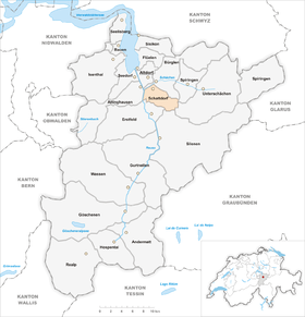
| Location of the municipality | |
  |
|


Schattdorf is a municipality in the canton of Uri in Switzerland .
geography

Schattdorf is located in Uri's Reuss Valley at the northern foot of the Bälmeten ( 2414 m above sea level ). The municipality boundary to Bürglen runs in the Schächen (-Bach) . The Reuss forms the western boundary of the municipality . The Teiftal valley to the southeast of the village, through which the Gangbach flows, also belongs to Schattdorf. In addition, the hamlet Haldi ( 1079 m above sea level. M. ) and the scattered settlements of the Schattdorf mountains (1'162- 1366 m above sea level. M. ). Haldi can be reached via a cable car and is the starting point for hikes, for example to the Wängihorn . To the south-west of the village lies the hamlet of Ried ( 452 m above sea level ) on the Reuss level on the cantonal road towards Erstfeld.
179 ha or 11.0% of the municipality is settlement area. Of this, 70 hectares are buildings, 57 hectares are industrial areas and 41 hectares are used for traffic. The agricultural area is more extensive with 546 hectares or a share of 33.6%. These include alpine areas, most of which are located in the Schattdorfer Berge community. These cover an area of 159 ha. A further 381 ha are meadow and arable land. In addition, 613 hectares or 37.7% of the municipal area are covered by forest and wood. Unproductive area comprises the remainder of the municipal area, namely 289 ha or 17.8%. It concerns almost exclusively areas without vegetation (high mountains) or areas with unproductive vegetation (high alpine vegetation).
Schattdorf borders Attinghausen to the west, Bürglen to the north, Spiringen and Unterschächen to the east and Silenen and Erstfeld to the south .
population
Population development
The population grew rapidly in the 1850s. In the following decade, growth flattened a little, but then picked up again sharply in the 1870s. Overall, the population grew by 298 people, or 36.3%, between 1850 and 1880. A brief slump followed until 1888 (1880–1888: −2.6%). From 1888 to 2000 there was uninterrupted growth. It was particularly strong between 1950 and 1980 (1950–1980: + 116.6%). The population has decreased slightly since 2000 (2000–2005: −1.4%)
| Population development | |||||||||||||
|---|---|---|---|---|---|---|---|---|---|---|---|---|---|
| year | 1850 | 1860 | 1870 | 1880 | 1888 | 1900 | 1950 | 1960 | 1970 | 1980 | 1990 | 2000 | 2005 |
| Residents | 822 | 954 | 1000 | 1120 | 1097 | 1128 | 2217 | 2754 | 3292 | 4516 | 4802 | 4897 | 4829 |
languages
The population speaks a highly Alemannic dialect. Almost the entire population speaks German as the everyday language. In the last census in 2000, 94.67% said German, 1.53% Serbo-Croatian and 0.90% Italian as their main language.
Religions - denominations
The population used to be fully members of the Roman Catholic Church. The denominational relationships in 2000 still show the original structure. 4,248 people were Catholic (86.75%). There were also 5.82% Evangelical Reformed and 1.49% Orthodox Christians, 1.55% Muslims and 2.43% non-denominational. 79 people (1.61%) did not provide any information on their creed.
Origin - nationality
Of the 4829 residents at the end of 2005, 4508 (93.35%) were Swiss citizens. The majority of the immigrants come from Central Europe (Germany), Southern Europe (Italy and Portugal), the former Yugoslavia (Serbia / Montenegro and Croatia) and Turkey. At the 2000 census, 4,487 people (91.63%) were Swiss citizens; 96 of them had dual citizenship.
age structure
The church has a high percentage of younger people. While the proportion of people under the age of twenty makes up almost 26.16% of the local population, only just under 15.72% are senior citizens (60 years and older). The average age is around 35 years.
The last census in 2000 showed the following age structure:
| Age | 0–6 years | 7-15 years | 16-19 years | 20-29 years | 30–44 years | 45–59 years | 60–79 years | over 79 years |
| number | 393 | 588 | 300 | 662 | 1095 | 1089 | 631 | 139 |
| proportion of | 8.03% | 12.01% | 6.13% | 13.52% | 22.36% | 22.24% | 12.89% | 2.84% |
politics

legislative branch
The municipal assembly forms the legislature. It usually meets twice a year.
executive
The seven-member municipal council forms the executive . He works part-time. Since January 1, 2015, the municipal council has been composed as follows:
- Rolf Zgraggen, Mayor (CVP)
- Claude Schunck, Municipal Vice President (SP)
- Fortunat von Planta, administrator (FDP)
- Rebecca Indergand Furrer, Social Director (CVP)
- Roman Walker, Member (CVP)
- Othmar Bissig, member (SVP)
- Urban Renggli, member (FDP)
economy
In 2005 there were 50 farms offering 125 jobs. Industry and trade employed 1003 people in 44 workplaces, the service sector in 92 companies 1075 people (employment converted to full-time positions). The 2000 census revealed 58 agricultural and forestry businesses with 159 employees. The 2001 census came to 45 industrial and commercial enterprises with 961 and 99 service companies with 1122 employees. The municipality, which used to be dominated by agriculture, now has a high proportion of industrial workers. Of the 2557 employed people in Schattdorf in 2000, 804 (31.44%) worked in their own community. In total, the place offered work to 2,037 people, of whom 804 (39.47%) were locals. An important area is the Rynächt industrial zone, in which many trading companies have recently settled and mostly opened their only branch in the canton of Uri - such as Manor , Jumbo , Fust or Otto’s . In the Rynächt you will also find the Tellpark shopping center , where you can find Hennes & Mauritz and a large Coop branch.
Schattdorf is part of the Altdorf / Schattdorf industrial center. Most of the 1753 commuters do their work in other communities in the canton of Uri. Including 916 people in Altdorf, 155 in Bürglen, 139 in Erstfeld, 45 in Flüelen, 33 in Silenen and 24 in Seedorf. Important places of work outside the canton are the municipalities of Schwyz (48 people) and Ingenbohl (23) in the canton of Schwyz , the city of Lucerne (46) and Emmen (15) in the canton of Lucerne , the municipalities of Stans (27) in the canton of Nidwalden and the canton of Zug the city of Zug (20). There were also 1233 inbound commuters. These came mainly from Altdorf (409 people), Erstfeld (175), Bürglen (167), Silenen (81), Seedorf (77), Attinghausen (74), Flüelen (56), Unterschächen (35) and Spiringen (34).
Attractions
Schattdorf's "local mountain", the Haldi, is a destination for excursions and can be reached by cable car.
Schattdorf also has a Catholic church, which is visible from afar because of its elevated position.
photos

View to the parish church

Parish Church of the Assumption of Mary

Parish Church of the Assumption of Mary

House "to the old saw"

Village school house from 1920

Schoolhouse from 1954
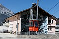
Valley station of the gondola to Haldi

Multipurpose building Grundmatt

View over Schattdorf into the Reuss Valley


Personalities
- Jolanda Annen (* 1992), triathlete
- Roman Furger (* 1990), cross-country skier
- Flavio Gisler (* 1989), politician and lawyer
- Gabi Huber (* 1956), politician
Web links
- Hans Stadler: Schattdorf. In: Historical Lexicon of Switzerland .
- Official website of the community of Schattdorf
- Haldi on haldi-uri.ch
Individual evidence
- ↑ Permanent and non-permanent resident population by year, canton, district, municipality, population type and gender (permanent resident population). In: bfs. admin.ch . Federal Statistical Office (FSO), August 31, 2019, accessed on December 22, 2019 .
- ↑ https://www.pxweb.bfs.admin.ch/Selection.aspx?px_language=de&px_db=px-x-0102020000_201&px_tableid=px-x-0102020000_201\px-x-0102020000_201.px&px_type=PX
Altdorf | Andermatt | Attinghausen | Build | Bürglen | Erstfeld | Flüelen | Göschenen | Belt pins | Hospental | Isenthal | Realp | Schattdorf | Seedorf | Seelisberg | Silenen | Sisikon | Spiringen | Undercuts | Water
Canton of Uri | Districts of the canton Uri | Municipalities of the Canton of Uri