
Silenen UR
| UR is the abbreviation for the canton of Uri in Switzerland and is used to avoid confusion with other entries of the name Silenen . |
| Silenen | |
|---|---|
 |
|
| State : |
|
| Canton : |
|
| District : | No district division |
| BFS no. : | 1216 |
| Postal code : |
6473 (Silenen UR) 6474 (Amsteg) 6475 (Bristen) |
| Coordinates : | 693 971 / 182 982 |
| Height : | 510 m above sea level M. |
| Height range : | 476–3327 m above sea level M. |
| Area : | 144.79 km² |
| Residents: | 1949 (December 31, 2018) |
| Population density : | 13 inhabitants per km² |
|
Proportion of foreigners : (residents without citizenship ) |
12.4% (December 31, 2,014) |
| Mayor : | Hermann Epp |
| Website: | www.silenen.ch |
 Silenen |
|
| Location of the municipality | |
  |
|
Silenen ( Rhaeto-Romanic ) is a municipality in the canton of Uri in Switzerland .
geography

The main town of the political community Silenen is the town of the same name on the right bank of the Reuss . It consists of the parts Dörfli, Russ and Rusli. Silenen also includes numerous hamlets, scattered settlements, groups of houses and individual farms. The northernmost settlement is Schützen ( 484 m above sea level ). It is located more than three kilometers north of the village of Silenen. South is Buechholz (525- 580 m asl. , 2.7 kilometers north of Silenen). Next up the valley follow Öfibach the same Bach (510- 560 m above sea level. M. ) and Dägerlohn south of Selderbachs ( 510 m above sea level. M. ). All are on the right bank of the Reuss. One kilometer southeast of Silenen is the hamlet of Frentschenberg ( 817 m above sea level ) above the Bristentobel on the southwest slope of the Kleine Windgällen . In the Reuss valley, on the other hand, is the village of Amsteg (1 km south of Silenen; 524 m above sea level , Rhaeto-Romanic ). The southernmost district of Silenens in the Reuss Valley is the scattered settlement Ried (Vorder- and Hinterried; 2.5 km southwest of the village). The Maderanertal through which the Chärstelenbach flows also belongs to the municipality . There are numerous hamlets and scattered settlements, not all of which are inhabited all year round. The foremost group of houses is St. Anton (or Vorderbristen; 716 m above sea level ). Further east is the village of Bristen (or Hinterbristen; 770 m above sea level ). Further into the valley we find Cholplatz ( 784 m above sea level ) and several hamlets lying next to one another (Hälteli, Steinmatte, Schattigmatt, etc.) From the Reussgrund we go up to the Golzeren high plateau . The settlements of Hofstetten and Silblen ( 1236 m above sea level ) are located between Maderanertal and Golzern . There are several hamlets on Golzeren, of which Egg , Hüseren (each 1395 m above sea level ) and Seewen ( 1423 m above sea level ) are the most important. The picturesque Golzerensee ( 1409 m above sea level ) is also located on the plateau .
Silenen is the largest municipality in terms of area in the canton of Uri. However, only 104 ha or 0.7% of the municipality's settlement area is among them. Of this, 48 hectares are again buildings and two hectares are industrial and 42 hectares are used for traffic. The agricultural area is more extensive with 1860 ha or a share of 12.8%. These include large alpine areas in the Maderanertal. These cover an area of 1444 hectares. In addition there are 407 hectares of meadow and arable land. In addition, 2647 hectares or 18.3% are covered by forest and wood. Unproductive area comprises the majority of the municipality, more precisely 9685 ha or 68.1%. These are almost exclusively areas without vegetation (high mountains and glaciers) or areas with unproductive vegetation (high alpine vegetation). The SAC Hüfihütte is located under the Hüfifirn glacier .
Neighboring communities of Silenen are Erstfeld and Gurtnellen in the west, Schattdorf , Unterschächen and the Spiringer exclave Urnerboden in the north, the Glarus community Glarus Süd and the Graubünden community Disentis in the east and the Graubünden Tujetsch in the south.
population
| Population development | |||||||||||||||||||||||||||||||||
|---|---|---|---|---|---|---|---|---|---|---|---|---|---|---|---|---|---|---|---|---|---|---|---|---|---|---|---|---|---|---|---|---|---|
|
|
||||||||||||||||||||||||||||||||
Around 1850, Silenen was in second place in terms of population after the canton capital Altdorf. At that time the community had over 1500 residents. That number continued to grow until 1870. An even higher population level was reached in 1880, but at that time there were numerous workers from the Gotthard railway construction site among them. The population continued to grow steadily for a long period. This lasted until 1970 (1850–1970: + 51.6%). The only exception was the 1940s. At that time there was a small slump (1941–1950: −9 people; −0.4%). The highest ever recorded population of Silenen was the 2493 inhabitants counted in 1920. From 1970 to 1990 there was massive emigration (1970–1990: −12.1%). Especially towards the lower Urner Reuss valley. In the 1990s the number of residents stagnated. However, in recent years there has been strong growth due to the construction of the Gotthard Base Tunnel (2000–2005: +214 people or 10.3%).
languages
The population speaks a highly Alemannic dialect. Almost the entire population speaks German as the everyday language. At the last census in 2000, 98.07% said German, 0.24% Serbo-Croatian and 0.19% Italian as their main language.
Religions - denominations
The population used to be fully members of the Roman Catholic Church. The denominational relationships in 2000 still show the original structure. 1,897 people were Catholic (91.73%). In addition, there were 2.80% Evangelical Reformed Christians and 1.60% non-denominational. 61 people (2.95%) did not provide any information on their creed.
Origin - nationality
Of the 2282 residents at the end of 2005, in 2001 (87.69%) were Swiss citizens. The majority of immigrants come from Central Europe (Austria), Southern Europe (Italy and Portugal), Croatia and Sri Lanka. At the 2000 census, 1989 people (96.18%) were Swiss citizens; thirteen of these had dual citizenship.
age structure
The community has a high proportion of younger residents. The proportion of people under the age of twenty of 25.48% of the local population is significantly higher than the proportion of people of senior age (60 years and older; 21.62%). However, it is noticeable that the adult age group between 20 and 44 years is well below average. This is due to the emigration of young people between 1970 and 1990.
The last census in 2000 showed the following age structure:
| Age | 0–6 years | 7-15 years | 16-19 years | 20-29 years | 30–44 years | 45–59 years | 60–79 years | ≥ 80 years |
|---|---|---|---|---|---|---|---|---|
| number | 162 | 248 | 117 | 235 | 463 | 396 | 358 | 89 |
| proportion of | 7.83% | 11.99% | 5.66% | 11.36% | 22.39% | 19.15% | 17.31% | 4.30% |
politics
legislative branch
The municipal assembly forms the legislature. It usually meets twice a year.
executive
The seven-member municipal council forms the executive. He works part-time. The current mayor is Hermann Epp (as of 2017).
economy
In 2005 there were 60 farms offering 141 jobs. Industry and trade employed 117 people in 16 workplaces, the service sector in 50 companies 241 people (employment converted to full-time positions). The 2000 census showed 66 farms and forest holdings with 173 employees. The 2001 census came to 12 industrial and commercial enterprises with 86 and 57 service companies with 217 employees. Of the 962 employed Silenians in 2000, 324 (33.68%) worked in their own community. In total, the place offered work to 496 people, of whom 324 (65.32%) were locals.
In the village Amsteg lies SBB - Kraftwerk Amsteg , which opened in 1922 and in 1998 replaced by a new hydroelectric power station in the mountain.
Most of the 638 commuters do their work in other communities in the canton of Uri. Including 214 people in Altdorf, 122 in Erstfeld, 81 in Schattdorf, 28 in Gurtnellen, 24 in Bürglen, 22 in Andermatt and 20 each in Flüelen and Göschenen. The only significant place of work outside the canton was the city of Lucerne with 15 people. There were also 172 commuters. These came mainly from Erstfeld (41 people), Schattdorf (33), Altdorf (21), Bürglen (14), Gurtnellen (12) and Seedorf (9).
history
In the district of Amsteg there was a melting furnace for the copper , lead and iron mining operated on the Bristenstock and the Windgällen until 1762 .
The Hotel Stern und Post , one of the oldest hotels in Switzerland, is located in Amsteg .
Attractions
- Tower of the Nobles of Silenen
- The 17 m high Meier Tower Silenen from the middle of the 13th century (built around 1240) to the south of the station . This five-story residential tower was once the seat of the noble barons of Silenen (1243–1363), who, as the so-called Meier von Silenen, were the estate managers of the properties of the Fraumünster Abbey of Zurich and thus also took care of the collection of tithes . The first Meier was knight Werner (1243–1258), then knight Arnold (1290–1294), at the same time mayor of Uri and co-summoner of the Eternal Covenant of 1291 on the Rütli .
- In 1989 the tower was renovated and provided with a battlement and a roof. The current owner of the tower is the Canton of Uri. In the summer of 2002, the tower was made accessible to the public with a staircase.
- Zwing-Uri Castle
- From the medieval Zwing-Uri castle , which was located on a hill on the north-eastern mountain flank above Amsteg, only the ruins of the residential tower remain.
- 14 Chapel of the Holy Helpers
- Right next to the Meier tower is the 14th Helper Chapel, first mentioned in 1081. It was restored in 1666 after a fire and today proves to be a place of worship of higher rank after frescoes from the 16th century came to light under several overpaintings, especially in the choir area .
- Railway bridge
The Gotthard Railway crosses the Maderaner Valley on the Chärstelenbach Bridge, built in 1882 .
photos
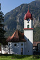
church

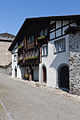
Steinhaus (cultural property protection)
Susthaus (cultural property protection)

Dörfli with the tower of the nobles

Amsteg

Amsteg, 1811
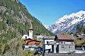
Bristen in Maderanertal

Amsteg in the foreground, photo between 1908 and 1920
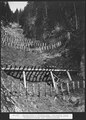
Roneboden-Stotzigzug, municipality of Silenen, snow bridges with rows of stakes, 1914


Personalities
- Jost von Silenen (1435–1497) was a statesman in the service of Louis XI , Bishop of Grenoble from 1475 and Bishop of Sitten from 1482.
- As a captain, Kaspar von Silenen led the first Swiss mercenaries to Rome, who began their duties as the Vatican Swiss Guard on January 22nd, 1506 .
- Johann Melchior Eggmann (1711–1756) created a ceiling fresco in the parish church of Silenen.
literature
- Thomas Brunner: The art monuments of the canton Uri. Volume 4: Upper Reuss Valley and Urseren. Edited by the Society for Swiss Art History GSK. (= Art Monuments of Switzerland. Volume 114). Bern 2008, ISBN 978-3-906131-89-4 , pp. 41-132.
Web links
- Official website of the municipality of Silenen
- Hans Stadler: Amsteg. In: Historical Lexicon of Switzerland .
- Hans Stadler: Silenians. In: Historical Lexicon of Switzerland .
- Amsteg on the ETHorama platform
Individual evidence
- ↑ Permanent and non-permanent resident population by year, canton, district, municipality, population type and gender (permanent resident population). In: bfs. admin.ch . Federal Statistical Office (FSO), August 31, 2019, accessed on December 22, 2019 .
- ↑ pxweb.bfs.admin.ch
- ↑ Hüfihütte
- ^ Charles Knapp, Maurice Borel, Victor Attinger, Heinrich Brunner, Société neuchâteloise de geographie (editor): Geographical Lexicon of Switzerland . Volume 1: Aa - Emmengruppe . Verlag Gebrüder Attinger, Neuenburg 1902, p. 72, keyword Amsteg ( scan of the lexicon page ).
- ↑ Eduard Müller, Hans Stadler, Jakob Obrecht: Tower and Dörfli Silenen (= Swiss Art Guide. No. 735, Series 74). Ed. Society for Swiss Art History GSK. Bern 2003, ISBN 3-85782-735-1 .
- ↑ Ch. Knapp, M. Borel, V. Attinger (Eds.): Geographisches Lexikon der Schweiz. Volume 1: AA - Emmengruppe. Attinger, Neuenburg 1902, p. 72.
Altdorf | Andermatt | Attinghausen | Build | Bürglen | Erstfeld | Flüelen | Göschenen | Belt pins | Hospental | Isenthal | Realp | Schattdorf | Seedorf | Seelisberg | Silenen | Sisikon | Spiringen | Undercuts | Water
Canton of Uri | Districts of the canton Uri | Municipalities of the Canton of Uri