
Maderanertal

The Maderanertal (French: Val de Fier ; Rhaeto-Romanic: ) is an eastern side valley of the Reuss valley .
location
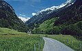
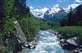
The valley is located in central Switzerland in the canton of Uri , at the northern foot of the Gotthard massif . It runs from northeast to west. The Chärstelenbach , which rises at the Hüfigletscher above the Hüfisees, flows in the valley floor . It flows west until, after about twelve kilometers, it joins the Reuss at Amsteg at about 500 m. To the north, the valley is bordered by the Gross Ruchen ( 3138 m ) and the Gross and Chli Windgällen ( 3187 m ), and to the south is the 3328 m high Oberalpstock . To the east it is closed by the Gross Düssi ( 3256 m ).
traffic
Coming from Amsteg, a narrow and spectacular road leads to Bristen , there are hardly any opportunities to avoid it. From the valley station of the Bristen-Golzeren cable car, behind Bristen, the rear Maderaner valley can be reached on foot or by off-road taxi. The Bristen-Golzeren cable car was renewed after the storm in 2005 . An alpine path leads to the Hüfihütte , from where the upper end of the valley can be reached via the Hüfigletscher.
At the end of the valley near Amsteg leading Chärstelenbachbrücke the Gotthard railway across the gorge.
Surname
Originally the Maderanertal was called Kerstelental . The current name can be traced back to the Madran family , who came from the village of Madrano in the Leventine community of Airolo and who emigrated to Altdorf in the 15th century .
photos
Chärstelenbach

Ore melting furnace, Hinterbristen
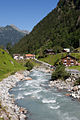
Valley entrance
View from the bridge on Graupelenweg
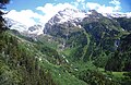
End of the valley with a view of the Gross Düssi

Bristen (village)

Golzerensee

Alp Golzeren

Valley station of the Golzerenbahn with the Chärstelenbach and the protective dike built after the 2005 floods
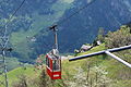
Golzerenbahn

Historical photo of the Hotel Maderanertal


_137.JPG)
_119.JPG)
_150.JPG)
_147.JPG)

Side valleys

The two most important side valleys of the Maderanertal are the Etzlital and the Brunnital (not to be confused with the Brunnital of the Schächental ).
Etzlital
The Etzlital branches off to the south from the Maderanertal at Cholplatz in Bristen and is around 8 km long. At the valley of Eztlitals lying Etzlihütte of the Swiss Alpine Club , from which one on the Chrüzlipass the Val Strem passes in the Grisons.
Brunnital
The Brunnibach, which has its origin in the Brunnifirn (or Brunnigletscher), flows through the approximately 12 km long Brunnital . The Hinterbalmhütte is located in this valley and the ascent to the Cavardirashütte leads through the Brunnital . The latter led over the Brunnifirn until a few years ago, but is now ice-free due to the retreat of the glacier in summer.
More side valleys
There are four other smaller valleys between Etzlital and Brunnital: Lungental, Grieserental, Staldental with the Staldenfirn and the Chästal. It is noticeable that all side valleys of the Maderanertal lie south of it.
literature
- Hugo Nünlist : The Maderanertal then and now. Murbacher, Lucerne 1968.
- Felix Aschwanden: "Düä Bääbä" - The Maderanertal. Gisler, Altdorf 2006.
- Hiking map of the Canton of Uri, 1: 60,000, Ed .: Kümmerli + Frey, ISBN 3-259-00873-X .
Web links
- Hans Stadler: Maderanertal. In: Historical Lexicon of Switzerland .
- Website of the municipality of Silenen / Amsteg / Bristen
- Hikes in the Maderanertal
Coordinates: 46 ° 46 ′ 24 " N , 8 ° 44 ′ 53" E ; CH1903: 700006 / 181 074