
Schächental
The Schächental is a side valley of the Reuss in the Swiss canton of Uri .
The valley name is derived from the river Schächen , which absorbs the precipitation and meltwater from an extensive mountain region and transports them to the Reuss and thus to Lake Lucerne .
geography
There are three villages in the Schächental:
In the east, the valley begins at the Klausen Pass , from which the Niemerstafelbach flows as one of the source streams of the Schächen towards the west. On the north side there are quite steep mountain slopes from Glatten to Rophaien (main summit Schächentaler Windgällen and Rossstock ), which are not interrupted by side valleys, but only have a few steep drainage channels. Larger mountain streams are the Gangbach near Witerschwanden, the Guggibach near Trudelingen and the Holdenbach near Brügg. The mountain crossing Chinzig Chulm leads from Bürglen and Spiringen to 2037 m. ü. M. to the Hürital in the canton of Schwyz to Muotatal .
The south side of the Schächental is more structured. The mountain slopes north of the massif with the over 3000 m high Clariden , Chammliberg , Schärhorn , Gross Ruchen and Gross Windgällen provide space for numerous alpine farms. The main valley is separated by three south-facing side valleys, the Brunnital , the Sulztal and the Riedertal . The Brunnital is through the Brunnibach or the Hinter Schächen , the Sulztal through the Sulzbach and the Plattisee at 2098 m. ü. M. and the Riedertal drained by the Riedertaler Bach .

Schächental, historical aerial photo from 1925, from a height of 3300 meters by Walter Mittelholzer

Autumn mood in the Schächental

From Äsch to Unterschächen

From Unterschächen to Äsch

Alp grayling with dust falling


Side valleys
The two most important side valleys of the Schächental are the Brunnital (not to be confused with the Brunnital of the Maderanertal) and the Riedertal.
Brunnital

The Brunnital is an approximately six kilometer long southern side valley of the Schächental in the Swiss canton of Uri . The furthest end of the valley is formed by the steep north walls of the Gross Ruchen ( 3138 m above sea level ), the Gross Windgallen ( 3187 m above sea level ) and the western Griesstal . From Brunnialp the Hinter Schächen , also called Brunnibach, flows together in Unterschächen with the Vorder Schächen ( coming from Äsch ) to form Schächen . In the rear valley lies at around 1400 m above sea level. M. the Alp Brunni (Brunnialp). In the middle valley at 1090 m above sea level. M. a cable car leads to the orographic left side of the valley to Sittlisalp at 1617 m above sea level. M. On the right side of the valley, also high above the Brunn Ibach, is the alp Trogen (Trogenalp).
In summer the valley is a popular hiking and climbing area, in winter it is the starting point for ski tours on the Gross Ruchen and Griesstal. Ice climbing can also be practiced in winter .

Unterächen at the entrance of the Brunnital
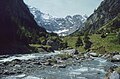
The Brunnibach or "Behind Schächen"


Individual evidence
- ↑ "Climbing in the Brunnital" in the SAC member magazine "DIE ALPEN" ( memento of the original from October 18, 2010 in the Internet Archive ) Info: The archive link was inserted automatically and has not yet been checked. Please check the original and archive link according to the instructions and then remove this notice.
- ↑ Dominik Osswald: The basics of ice climbing. Der Bund , Bern February 27, 2017, article on page 26
Web links
- Hans Stadler: Schächental. In: Historical Lexicon of Switzerland .
Coordinates: 46 ° 51 ′ 52 " N , 8 ° 45 ′ 38" E ; CH1903: seven hundred thousand seven hundred ninety / 191217