
Cavardirashütte
| Cavardirashütte SAC mountain hut |
||
|---|---|---|
 Cavardirashütte from the west |
||
| Mountain range | Glarus Alps | |
| Geographical location: | 705 119 / 177730 | |
| Altitude | 2649 m above sea level M. | |
|
||
| owner | SAC Winterthur | |
| Built | 1928 | |
| Construction type | Mountain hut | |
| Usual opening times | Mid-July to mid-September | |
| accommodation | 65 beds | |
| Winter room | 30 bearings | |
| Web link | Cavardirashütte | |
| Hut directory | SAC | |

The Cavardirashütte ( Rhaeto-Romanic in the idiom Sursilvan Camona da Cavardiras ) is a mountain hut of the Winterthur section of the Swiss Alpine Club (SAC).
location
It is located in the Swiss canton of Graubünden , a little east of the Fuorcla da Cavardiras at an altitude of 2649 m above sea level. M. West of the cabin is the Brunnifirn and the Oberalpstock solid .
history
The hut was built in 1928 and expanded in 1974 and 1986. The last structural measures were carried out in 2006 in the basement. It offers space for 65 people. In 2007 a new kitchen was put into operation.
Accesses
- from Disentis or Caischavedra (mountain station of the BBD cable car) via Val da Lag Serein, Brunnipass, Brunnigrat and Brunnifirn (chain protection on the pass and ridge, ladder descent to Brunnifirn, path over the glacier marked), white-blue-white alpine route, shortest ascent to the hut, 3.5 to 4.5 hours, 860 meters in altitude from Caischavedra
- from Disentis or Sumvitg via Val Russein, white-red-white, easy but long ascent, 5 to 6 hours, 1600 meters in altitude from Cumpadials or 3.5 hours, 900 meters in altitude from Alp Russein (taxi service possible to there)
- Maderanertal - Brunnital - Hinterbalmhütte - Fuorcla da Cavardiras, white-red-white, long (7 to 8 h, 1800 m difference in altitude)
photos
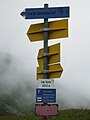
Signpost to the hut at Lag Serein
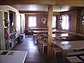
In the Cavardira hut

Hut seen from the approach from Val Surrein
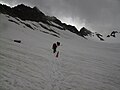
The marked path over the Brunnifirn to the hut, in the background the Brunnigrat

View from the hut terrace on the Brunnifirn
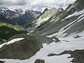
View from the hut to the east into the upper Val Russein


