
Oberalpstock
| Oberalpstock | ||
|---|---|---|
 Oberalpstock |
||
| height | 3328 m above sea level M. | |
| location | Uri / Graubünden , Switzerland | |
| Mountains | Glarus Alps | |
| Dominance | 12.7 km → Stoc Grond | |
| Notch height | 704 m ↓ Fuorcla di Cavardiras | |
| Coordinates | 701 698 / 177674 | |
|
||
| First ascent | 1793 Placidus a Spescha , J. Senoner | |

The Oberalpstock ( Rhaeto-Romanic Piz Tgietschen (red mountain)) is at an altitude of 3328 m above sea level. M. the highest mountain in the crystalline southwestern part of the Glarus Alps in Switzerland . In addition to the main summit, there is the south summit and the north summit , each with a height of 3295 meters. The mountain sends pronounced ridges in all four directions . Its name is derived from the Oberalp at its north-western foot.
Location and surroundings
The mountain rises between the canton of Uri belonging Maderanertal the north and the Grisons Vorderrheintal at Sedrun in the south. Neighboring mountains are the 3085 meter high Chli Oberälpler in the northeast, the Piz Ault with 3027 meters in the southeast and the Witenalpstock (3016 m) in the southwest . To the west, the Oberalpstock falls into the Etzlital and to the north into the Maderanertal. The summit panorama is considered to be one of the most beautiful in the Central Alps.
geology
Geologically, the Oberalpstock is part of the Aar massif and is made up of the so-called Central Aare granite . North below its north side in Maderanertal are chlorite - serizithaltige - gneiss and schist and quartz porphyries and amphibolites minded .
glacier
The Brunnifirn extends from the Oberalpstock to the east almost to the Fuorcla da Cavardiras over a length of approx. 2.5 km. In the lower part of the glacier there are few crevasses ; the path from Disentis to the Cavardirashütte leads over it. In the upper, steeper part, however, the glacier surface is quite rugged. The normal route to the Oberalpstock leads over the Brunnifirn. Since 1978 the glacier has become approx. 120 m shorter and now ends at approx. 2600 m (previously it also extended into the Brunnital). The much smaller Staldenfirn extends from the summit to the north .
Ascent routes
The route of the first ascent in 1793 led from the Cavardirastal valley to the east over the south-east side over the Brunnifirn to the summit. This route is still the normal route today , the easiest ascent, but which is becoming increasingly difficult due to the melting of the glacier . The base for an ascent of the Oberalpstock via the normal route is the Cavardirashütte of the SAC Winterthur section at an altitude of 2649 meters . Other routes, partly at risk of falling rocks due to fragile rock , lead difficult to fairly difficult (S to ZS) , over the southwest flank (since 1847), across the north and west ridge and through the north-west face, which was first climbed in 1919.
photos
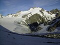
The Oberalpstock from the Cavardirashütte

Oberalpstock and Brunnifirn

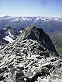
Normal route and summit construction
Brunnifirn with normal route

Ascent to the Oberalpstock over the Brunnifirn

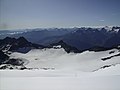
View to SW with the Valais Alps in the background
South summit and view to S, Lai da Nalps
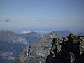
Looking north towards Germany


Literature and map
- Toni Fullin, Andy Banholzer: SAC club leader , Oberalpstock, Windgällen. Verlag des SAC 2010, ISBN 978-3-85902-311-6
- National map of Switzerland 1: 25,000, sheet 1212, Amsteg
Individual evidence
- ↑ Brief geological overview of the Maderanertal - Arni - Erstfeldertal region (PDF, 117 kB) ( Memento of the original from September 24, 2015 in the Internet Archive ) Info: The archive link was inserted automatically and has not yet been checked. Please check the original and archive link according to the instructions and then remove this notice.
- ^ National map of Switzerland 1: 25000, sheet 1212 Amsteg, 2005
- ^ Research Institute for Hydraulic Engineering, Hydrology and Glaciology (VAW) of the ETH Zurich (ed.): Brunnifirn. In: Swiss Glacier Measurement Network. ( ethz.ch , also as PDF ).
- ↑ Toni Fullin / Andy Banholzer: SAC-Clubführer, Oberalpstock, Windgällen , Verlag des SAC 2010, p. 392 ff., Margin no. 662 ff.
Web links
- Oberalpstock tour reports and photos
- Ski tour description from the Disentis ski area