
Leventina district
| Leventina district | |
|---|---|
 |
|
| Basic data | |
| Country: |
|
| Canton : |
|
| Main town : | Faido |
| FSO number : | 2103 |
| Area : | 479.55 km² |
| Height range : | 285–3153 m above sea level M. |
| Residents: | 9113 (December 31, 2018) |
| Population density : | 19 inhabitants per km² |
| map | |
 |
|
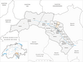
The Leventina district (ital. Distretto di Leventina, older German Livinen ) is a district of the Swiss canton of Ticino . Geographically, it includes the valley of the Ticino river to Biasca , namely the Val Bedretto and Valle Leventina . The main town is Faido .
The district is divided into four circles (circoli)
which contain a total of 10 municipalities.
| coat of arms | Name of the parish | Population (December 31, 2018) |
Area in km² |
Inhabitant per km² |
circle |
|---|---|---|---|---|---|
|
|
Airolo | 1501 | 94.35 | 16 | Airolo |
|
|
Bedretto | 110 | 75.18 | 1 | Airolo |
|
|
Faido | 2903 | 132.59 | 22nd | Faido |
|
|
Bodio | 992 | 6.48 | 153 | Giornico |
|
|
Giornico | 858 | 94.35 | 16 | Giornico |
|
|
Personico | 335 | 38.87 | 9 | Giornico |
|
|
Pollegio | 800 | 5.96 | 134 | Giornico |
|
|
Dalpe | 182 | 14.55 | 13 | Quinto |
|
|
Prato (Leventina) | 406 | 16.82 | 24 | Quinto |
|
|
Quinto | 1026 | 75.21 | 14th | Quinto |
| Total (10) | 9113 | 479.55 | 19th | (4) | |
- Change of name from Prato on October 14, 1940.
Changes in the community
Parishes until 1853

Municipalities until 1901

Municipalities until 1940

Municipalities until 2006

Municipalities until 2012

Municipalities until 2016


- January 1, 1902: Name changed from Prato (Leventina) → Prato-Fiesso
- October 14, 1940: Name change from Prato-Fiesso → Prato (Leventina)
- January 29, 2006: Fusion Calonico , Chiggiogna , Faido and Rossura → Faido
- April 1, 2012: Fusion of Anzonico , Calpiogna , Campello , Cavagnago , Chironico , Faido , Mairengo and Osco → Faido
Individual evidence
- ↑ Permanent and non-permanent resident population by year, canton, district, municipality, population type and gender (permanent resident population). In: bfs. admin.ch . Federal Statistical Office (FSO), August 31, 2019, accessed on December 22, 2019 .
- ↑ Federal Statistical Office Generalized Limits 2020.
Web links
Commons : Leventina district - collection of pictures, videos and audio files
- Mario Fransioli, Tiziano Locarnini: Leventina. In: Historical Lexicon of Switzerland .