
Vallemaggia district
| Vallemaggia district | |
|---|---|
 |
|
| Basic data | |
| Country: |
|
| Canton : |
|
| Main town : | Cevio |
| FSO number : | 2108 |
| Area : | 569.37 km² |
| Height range : | 243–3270 m above sea level M. |
| Residents: | 5970 (December 31, 2018) |
| Population density : | 10 inhabitants per km² |
| map | |
 |
|
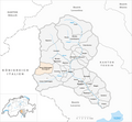
The district of Vallemaggia (ital. Distretto di Vallemaggia, former Landvogtei Maiental ) is a district of the Swiss canton of Ticino . It includes the Valle Maggia (German today Maggia Valley, formerly Maiental ) and its side valleys. The main town is Cevio . The district is divided into three circles (circoli)
and eight parishes.
| coat of arms | Name of the parish | Population (December 31, 2018) |
Area in km² |
Inhabitant per km² |
circle |
|---|---|---|---|---|---|
|
|
Lavizzara | 509 | 187.53 | 3 | Lavizzara |
|
|
Avegno Gordevio | 1518 | 27.32 | 56 | Maggia |
|
|
Maggia | 2592 | 111.16 | 23 | Maggia |
|
|
Bosco / Gurin | 46 | 22.00 | 2 | Rovana |
|
|
Campo (Vallemaggia) | 53 | 43.30 | 1 | Rovana |
|
|
Cerentino | 45 | 20.10 | 2 | Rovana |
|
|
Cevio | 1159 | 151.31 | 8th | Rovana |
|
|
Linescio | 48 | 6.66 | 7th | Rovana |
| Total (8) | 5970 | 569.37 | 10 | (3) | |
Changes in the parish

Municipalities until 1910

Municipalities until 1911
Municipalities until 1933

Municipalities until 1935

Municipalities until 2003

Municipalities until 2006

Municipalities until 2008


- 1864: Fusion of Prato and Sornico → Prato-Sornico
- 1911: Change of name from Bosco (Gurin) → Gurin
- 1912: Change of name from Gurin → Bosco (Vallemaggia)
- 1934: Change of name from Bosco (Vallemaggia) → Bosco / Gurin
- April 4, 2004: Fusion of Aurigeno , Moghegno , Maggia , Lodano , Coglio , Giumaglio and Someo → Maggia
- April 4, 2004: Merger of Brontallo , Menzonio , Broglio , Prato-Sornico , Peccia and Fusio → Lavizzara
- October 22, 2006: Merger of Cevio , Bignasco and Cavergno → Cevio (The municipality of Bignasco brought an action against this merger in federal court . In April 2006, the court ruled against Bignasco.)
- April 20, 2008: Merger of Avegno and Gordevio → Avegno-Gordevio
literature
- Daniela Pauli Falconi: Vallemaggia. In: Historical Lexicon of Switzerland . 2014 .
Web links
Individual evidence
- ↑ Permanent and non-permanent resident population by year, canton, district, municipality, population type and gender (permanent resident population). In: bfs. admin.ch . Federal Statistical Office (FSO), August 31, 2019, accessed on December 22, 2019 .
- ↑ Federal Statistical Office Generalized Limits 2020.
Avegno Gordevio | Bosco / Gurin | Campo (Vallemaggia) | Cerentino | Cevio | Lavizzara | Linescio * | Maggia
* This municipality does not own any objects of the categories A or B, but can have (currently undocumented) C objects

Four parishes: Bolligen | Vechigen | Stettlen | Muri
Regional courts: Seftigen | Sternenberg | Konolfingen | Zollikofen
Offices: Thun | Zofingen | Aarau | Lenzburg | Brugg | Burgdorf | Büren | Unterseen | Wiedlisbach | Obersimmental | Lower Simmental | Frutigen | Oberhofen | Aigle | Hasli | Trachselwald | Bipp | Aarwangen | Cheeks | Landshut | Lenzburg (Office) | Schenkenberg | Aarberg | Nidau | Erlach | Laupen | Oltigen | Signau | Biberstein | Aarburg | Saanen | Brandis | Interlaken | Königsfelden | Thorberg | Fraubrunnen | Zofingen (pen) | Frienisberg | St. Johannsen | Gottstatt | Buchsee | Sumiswald | Roche (Saline) | Köniz | Kasteln | Hettiswil
Offices in Vaud: Avenches | Moudon | Yverdon | Lausanne | Morges | Nyon | Vevey | Romainmôtier | Oron | Payerne | Bonmont | Aubonne
Common lords with Freiburg: Schwarzenburg | Murten | Grandson | Echallens
Common federal dominions: Baden | Thurgau | Free offices | Rhine Valley | Sargans | Locarno | Lugano | Mendrisio | Valle Maggia
Offices and services in the city of Bern: Bauamt | Salt Directorate | Mushafen | Pen | Corn Office | Big hospital | Inselspital