
Fraubrunnen district
| Fraubrunnen district | |
|---|---|
 |
|
| Basic data | |
| Country: |
|
| Canton : |
|
| Main town : | Fraubrunnen |
| Area : | 123.72 km² |
| Residents: | 39,569 (December 31, 2008) |
| Population density : | 320 inhabitants per km² |
| map | |
 |
|
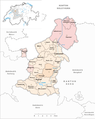
The Fraubrunnen district was an administrative unit of the Canton of Bern until December 31, 2009 . The administrative district with the capital Fraubrunnen comprised 27 communities on 123.72 km²:
Communities
| Name of the parish | Population (December 31, 2008) |
Area in km² | Inhabitants per km² |
|---|---|---|---|
| Ball moss | 54 | 1.50 | 36 |
| Banged | 161 | 2.20 | 73 |
| Bätterkinden | 2996 | 10.19 | 294 |
| Büren to the yard | 478 | 3.50 | 137 |
| Deisswil near Münchenbuchsee | 95 | 2.16 | 44 |
| Diemerswil | 203 | 2.86 | 71 |
| Etzelkofen | 315 | 2.80 | 113 |
| Fraubrunnen | 1777 | 7.70 | 231 |
| Grafenried | 945 | 4.70 | 201 |
| Iffwil | 409 | 5.06 | 81 |
| Jegenstorf | 4630 | 7.40 | 626 |
| Limpach | 338 | 4.40 | 77 |
| Mattstetten | 590 | 3.79 | 156 |
| Moosseedorf | 3555 | 6.38 | 557 |
| Mülchi | 241 | 3.80 | 63 |
| Münchenbuchsee | 9750 | 8.81 | 1107 |
| Münchringen | 562 | 2.40 | 234 |
| Ruppoldsried | 264 | 2.20 | 120 |
| Shells | 387 | 1.40 | 276 |
| Barns | 77 | 2.00 | 39 |
| Urtenen-Schönbühl | 5580 | 7.19 | 776 |
| Utzenstorf | 4080 | 16.94 | 241 |
| Wiggiswil | 106 | 1.44 | 74 |
| Wiler near Utzenstorf | 804 | 3.82 | 210 |
| Zauggenried | 318 | 3.70 | 86 |
| Zielebach | 330 | 1.91 | 173 |
| Zuzwil (BE) | 524 | 3.47 | 151 |
| Total (27) | 39,569 | 123.72 | 320 |
Changes in the community

Municipalities until 1911
Municipalities until 2009


- 1912: Fusion of mess barns and upper barns → barns
- 2010: Fusion Ballmoos and Jegenstorf → Jegenstorf
- 2010: District change from Bangerten and Ruppoldsried from the district of Fraubrunnen → administrative district of Seeland
- 2010: District change from Bätterkinden , Utzenstorf , Wiler bei Utzenstorf , and Zielebach from the district of Fraubrunnen → administrative district of Emmental
- 2010: Change of district of all other 20 communities from the Fraubrunnen district → Bern-Mittelland administrative district
Web links
Individual evidence
Aarberg | Aarwangen | Bern | Biel | Büren | Burgdorf | Courtelary | Erlach | Fraubrunnen | Frutigen | Interlaken | Konolfingen | Laupen | Moutier | La Neuveville | Nidau | Lower Simmental | Oberhasli | Obersimmental | Saanen | Schwarzenburg | Juicy | Signau | Tuna | Trachselwald | Cheeks
Canton of Bern | Districts of Switzerland | Municipalities of the Canton of Bern

Four parishes: Bolligen | Vechigen | Stettlen | Muri
Regional courts: Seftigen | Sternenberg | Konolfingen | Zollikofen
Offices: Thun | Zofingen | Aarau | Lenzburg | Brugg | Burgdorf | Büren | Unterseen | Wiedlisbach | Obersimmental | Lower Simmental | Frutigen | Oberhofen | Aigle | Hasli | Trachselwald | Bipp | Aarwangen | Cheeks | Landshut | Lenzburg (Office) | Schenkenberg | Aarberg | Nidau | Erlach | Laupen | Oltigen | Signau | Biberstein | Aarburg | Saanen | Brandis | Interlaken | Königsfelden | Thorberg | Fraubrunnen | Zofingen (pen) | Frienisberg | St. Johannsen | Gottstatt | Buchsee | Sumiswald | Roche (Saline) | Köniz | Kasteln | Hettiswil
Offices in Vaud: Avenches | Moudon | Yverdon | Lausanne | Morges | Nyon | Vevey | Romainmôtier | Oron | Payerne | Bonmont | Aubonne
Common lords with Freiburg: Schwarzenburg | Murten | Grandson | Echallens
Common federal dominions: Baden | Thurgau | Free offices | Rhine Valley | Sargans | Locarno | Lugano | Mendrisio | Valle Maggia
Offices and services in the city of Bern: Bauamt | Salt Directorate | Mushafen | Pen | Corn Office | Big hospital | Inselspital