
Banged
| Banged | ||
|---|---|---|
 |
||
| State : |
|
|
| Canton : |
|
|
| Administrative district : | Zealand | |
| Residential municipality : | Rapperswil | |
| Postal code : | 3256 | |
| former BFS no. : | 0532 | |
| Coordinates : | 600 829 / 211638 | |
| Height : | 586 m above sea level M. | |
| Area : | 2.2 km² | |
| Residents: | 161 (December 31, 2015) | |
| Population density : | 73 inhabitants per km² | |
| Website: | www.rapperswil-be.ch | |
_036.JPG) Bangerten school building |
||
| map | ||
|
||


Bangerten is a village in the municipality of Rapperswil (BE) in the Seeland administrative district in the canton of Bern in Switzerland .
geography
Bangerten is 586 m above sea level. M. , 12 km north of the canton capital Bern (linear distance). The small village extends a scenic location on a hill on the northeast edge of the upper timber, in the middle of Rapperswil plateau in the Swiss Plateau .
The area of the 2.2 km² former municipal area covers a section of the central Bernese plateau. The area with little relief descends towards the east into the Mulde des Moos with the headwaters of the Woolibach , which flows south to Moossee . In the north, the municipal ban extends into the undergrowth in which the Mülchibach rises and to the edge of the junk wood . The Mülchibach drains the northern part of the municipality to the Limpach . To the southwest, the former municipality extends into the Oberholz and the Schnarz , on which 622 m above sea level. M. the highest point of the Rapperswil plateau is reached. In 1997, 5% of the former municipal area was accounted for by settlements, 31% for forests and woodlands and 64% for agriculture.
Bangerten includes the hamlet of Hohrain ( 580 m above sea level ) on the northwest slope of the Oberholz and two individual farms. The former neighboring communities of Bangerten were Jegenstorf , Iffwil , Zuzwil (BE) and Rapperswil (BE) .
population
With 161 inhabitants (as of December 31, 2015) Bangerten was one of the smallest communities in the canton of Bern. 93.7% of the residents are German-speaking, 1.9% French-speaking and 1.9% speak Arabic (as of 2000). The population of Bangerten was 180 inhabitants in 1850 and 228 inhabitants in 1900. In the course of the 20th century, the population decreased by almost 40% to 141 people by 1970 due to strong emigration. This was followed by a longer period of stagnation and, since 1990, a slight increase in population.
politics
The voting shares of the parties on the occasion of the 2015 National Council election were: SVP 47.9%, BDP 21.7%, glp 8.5%, SP 8.1%, FDP 7.4%, GPS 4.3%, PdA 1.2 % EVP 0.2%, CVP 0.2%.
economy
Bangerten was a predominantly agricultural village until the second half of the 20th century . Even today, arable farming , fruit growing , dairy farming and forestry have an important place in the income structure of the population. A few other jobs are available in local small businesses and in the service sector, including a carpenter's workshop. In the last few decades the village has developed into a residential community thanks to its attractive location. Many workers are therefore commuters who mainly work in the Bern agglomeration.
traffic
The community is located off the major thoroughfare on a connecting road from Jegenstorf to Rapperswil (BE) . The closest connection to the A6 motorway (Bern-Biel) is around 4 km from the town center. Bangerten has no connection to the public transport network.
history
The first written mention of the place took place in 1263 under the name Bongarten . Later the names Bongarthen (1306), Boumgarten (1528), Bangartten (1575), Banngarten (1577), Bangarten (1789) and Bangerten (1850) appeared. The place name goes back to the Middle High German word boumgarte (piece of land with fruit trees).
Since the Middle Ages Bangerten was under the Count of Kyburg . In the 13th century the manor came to the Johanniter Commandery in Münchenbuchsee. Since 1406, sovereignty over the area near Bern was incumbent. After the Kommende was secularized in 1528, Bangerten was assigned to the Landvogtei Münchenbuchsee in the Zollikofen district court . After the collapse of the Ancien Régime (1798), the village belonged to the Zollikofen district during the Helvetic Republic and from 1803 to the Fraubrunnen Oberamt, which received the status of an official district with the new cantonal constitution of 1831. In 1847 a cheese cooperative was founded in the village.
On January 1, 2016, the municipalities of Bangerten and Rapperswil merged to form the municipality of Rapperswil (BE) .
Attractions
Bangerten has preserved a remarkable townscape with numerous characteristic farmhouses (half-timbered buildings) from the 18th and 19th centuries. The village does not have its own church, it belongs to the parish of Rapperswil.

Entrance to Bangerten

The historic building of the Gasthaus Löwen
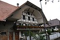
Half-timbered house in the center of Bangerten

Fire station
_026.JPG)
_053.JPG)
_056.JPG)
_047.JPG)
Web links
Individual evidence
- ^ Results of the Bangerten community. State Chancellery of the Canton of Bern, October 18, 2015, accessed on April 19, 2016 .
Aarberg | Arch | Barges | Shaking | Büetigen | Bühl | Büren an der Aare | Diessbach near Büren | Dotzigen | Epsach | Erlach | Dark hens | Gals | Gampelen | Grossaffoltern | Hagneck | Hermigen | Ins | Jens | Kallnach | Kappelen | Leuzigen | Lüscherz | Lyss | Meienried | Merzligen | Müntschemier | Oberwil near Büren | Radelfingen | Rapperswil | Rüti near Büren | Hatching | Seedorf | Siselen | Studen (BE) | Täuffelen | Riding | Tschugg | Vinelz | Walperswil | Wengi | Advertised
Former parishes: Bangerten | Busswil near Büren | Gas ore | Mullen | Niederried near Kallnach | Rubbing | Ruppoldsried
Canton of Bern | Administrative districts of the canton of Bern | Municipalities of the Canton of Bern