
Walperswil
| Walperswil | |
|---|---|
 |
|
| State : |
|
| Canton : |
|
| Administrative district : | Zealand |
| BFS no. : | 0754 |
| Postal code : | 3272 |
| Coordinates : | 583910 / 212106 |
| Height : | 468 m above sea level M. |
| Height range : | 437–479 m above sea level M. |
| Area : | 6.96 km² |
| Residents: | 1043 (December 31, 2018) |
| Population density : | 150 inhabitants per km² |
| Mayor : | Christian Mathys ( SVP ) |
| Website: | www.walperswil.ch |
_307.JPG) Walperswil |
|
| Location of the municipality | |
  |
|
Walperswil is a municipality in the Seeland administrative district in the canton of Bern in Switzerland . It consists of the districts of Walperswil and Gimmiz.
geography
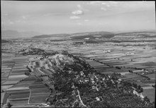
The municipality is located on the northern edge of the Grosse Moos on the Aare-Hagneck Canal . The village is laid out on a long hill above the plain. The district of Gimmiz is located in the flat area east of the village. The Walperswil Bridge leads over the Hagneck Canal.
The neighboring communities in the north, starting clockwise, are Epsach , Bühl BE , Kappelen BE , Bargen BE , Siselen , Hagneck and Täuffelen . The Aare - Hagneck Canal forms the southern municipal boundary .
Land survey
In the 19th century, an important stage in Swiss national surveying began in Walperswil . A monument of national importance, which was inaugurated on May 20, 2006 in Walperswil, testifies to this. It is the north end of the baseline in the Grosse Moos , which was placed under monument protection on the initiative of the Bernese Heritage Protection Agency. The 13 km long route between Walperswil and Sugiez FR was last measured for the Dufour map in 1834 ; it thus determined the geometric size of Switzerland until the end of the 19th century. ⊙ ⊙
politics
The voting shares of the parties at the 2015 National Council election were: SVP 50.9%, BDP 18.1%, SP 10.2%, FDP 6.6%, glp 4.7%, EPP 3.4%, GPS 2.3 %, CVP 1.4%, EDU 1.1%.
Personalities
- Eduard Güder (1817–1882), Reformed theologian
- Friedrich Baumann (1835–1910), master builder and politician
Attractions
photos

reformed Church

Walperswil rectory

Village center
_321.JPG)
_328.JPG)
_325.JPG)
literature
- Andres Moser: The art monuments of the canton of Bern. Landband 2: The Erlach district, the Nidau district. Part 1. Edited by the Society for Swiss Art History GSK. Wiese, Basel 1998, (Art Monuments of Switzerland, Volume 90). ISBN 3-909164-63-3 . Pp. 374-386.
Web links
- Official website of the Walperswil community
- Cultural and historical monument: surveying the base of the Dufour map (PDF file; 1.15 MB)
- Anne-Marie Dubler : Walperswil. In: Historical Lexicon of Switzerland .
Individual evidence
- ↑ Permanent resident population from STAT-TAB of the BfS , municipalities see also regional portraits 2020 on bfs.admin.ch, accessed on May 29, 2020
- ↑ Martin Rickenbacher: The basic measurements in the large moss between Walperswil and Sugiez
- ^ Results of the Walperswil community. State Chancellery of the Canton of Bern, October 18, 2015, accessed on April 17, 2016 .
Aarberg | Arch | Barges | Shaking | Büetigen | Bühl | Büren an der Aare | Diessbach near Büren | Dotzigen | Epsach | Erlach | Dark hens | Gals | Gampelen | Grossaffoltern | Hagneck | Hermigen | Ins | Jens | Kallnach | Kappelen | Leuzigen | Lüscherz | Lyss | Meienried | Merzligen | Müntschemier | Oberwil near Büren | Radelfingen | Rapperswil | Rüti near Büren | Hatching | Seedorf | Siselen | Studen (BE) | Täuffelen | Riding | Tschugg | Vinelz | Walperswil | Wengi | Advertised
Former parishes: Bangerten | Busswil near Büren | Gas ore | Mullen | Niederried near Kallnach | Rubbing | Ruppoldsried
Canton of Bern | Administrative districts of the canton of Bern | Municipalities of the Canton of Bern