
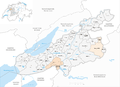
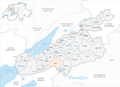
Zealand administrative district
| Zealand administrative district | |
|---|---|
| Basic data | |
| Country: |
|
| Canton : |
|
| Main town : | Aarberg |
| FSO number : | 0243 |
| Area : | 336.76 km² |
| Height range : | 424–821 m above sea level M. |
| Residents: | 74,467 (December 31, 2018) |
| Population density : | 221 inhabitants per km² |
| map | |
 |
|
The administrative district of Seeland in the canton of Bern was founded on January 1st, 2010. It belongs to the administrative region of Zealand and comprises 42 municipalities on 336.76 km² with a total of 74,467 inhabitants (as of January 1, 2019) .
Communities
| coat of arms | Name of the parish | Population (December 31, 2018) |
Area in km² | Inhabitants per km² |
|---|---|---|---|---|
|
|
Aarberg | 4628 | 7.93 | 584 |
|
|
Arch | 1594 | 6.38 | 250 |
|
|
Barges (BE) | 999 | 7.86 | 127 |
|
|
Shaking | 578 | 6.61 | 87 |
|
|
Büetigen | 870 | 3.61 | 241 |
|
|
Buhl | 464 | 2.97 | 156 |
|
|
Büren on the Aare | 3583 | 12.60 | 284 |
|
|
Diessbach near Büren | 989 | 6.33 | 156 |
|
|
Dotzigen | 1461 | 4.23 | 345 |
|
|
Epsach | 317 | 3.41 | 93 |
|
|
Erlach | 1385 | 3.49 | 397 |
|
|
Dark hens | 571 | 3.57 | 160 |
|
|
Gals | 827 | 7.84 | 105 |
|
|
Gampelen | 963 | 10.60 | 91 |
|
|
Big mouths | 3018 | 15.08 | 200 |
|
|
Hagneck | 413 | 1.84 | 224 |
|
|
Hermigen | 322 | 3.42 | 94 |
|
|
Ins | 3564 | 23.87 | 149 |
|
|
Jens | 659 | 4.58 | 144 |
|
|
Kallnach | 1920 | 17.98 | 107 |
|
|
Kappelen | 1419 | 10.97 | 129 |
|
|
Leuzigen | 1259 | 10.28 | 122 |
|
|
Lüscherz | 560 | 5.42 | 103 |
|
|
Lyss | 15,282 | 14.83 | 1030 |
|
|
Meienried | 59 | 0.65 | 91 |
|
|
Merzligen | 393 | 2.30 | 171 |
|
|
Müntschemier | 1406 | 4.87 | 289 |
|
|
Oberwil near Büren | 875 | 6.74 | 130 |
|
|
Radelfingen | 1285 | 14.71 | 87 |
|
|
Rapperswil (BE) | 2618 | 22.58 | 116 |
|
|
Rüti near Büren | 859 | 6.50 | 132 |
|
|
Scoop | 3734 | 19.84 | 188 |
|
|
Seedorf (BE) | 3116 | 20.87 | 149 |
|
|
Siselen | 595 | 5.51 | 108 |
|
|
Hours (BE) | 3326 | 2.73 | 1218 |
|
|
Tauffelen | 2872 | 4.37 | 657 |
|
|
Riding | 416 | 4.74 | 88 |
|
|
Tschugg | 458 | 3.29 | 139 |
|
|
Vinelz | 867 | 4.56 | 190 |
|
|
Walperswil | 1043 | 6.96 | 150 |
|
|
Wengi | 613 | 7.08 | 87 |
|
|
Advertised | 2287 | 2.76 | 829 |
| Total (42) | 74,467 | 336.76 | 221 | |
The municipalities come from the previous administrative districts
- Aarberg (11),
- Büren (11),
- Erlach (12),
- Fraubrunnen (2) and
- Nidau (10).
Changes in the community since 2010

Municipalities until 2010
Municipalities until 2012

Municipalities until 2015
Municipalities by 2018


- Mergers
- 2011: Busswil near Büren and Lyss → Lyss
- 2013: Niederried near Kallnach and Kallnach → Kallnach
- 2013: Ruppoldsried and Rapperswil → Rapperswil
- 2016: Bangerten and Rapperswil → Rapperswil
- 2019: Golaten ( Bern-Mittelland administrative district ) and Kallnach → Kallnach
Web links
Commons : Verwaltungskreis Seeland - Collection of images, videos and audio files
Individual evidence
- ↑ Permanent resident population from STAT-TAB of the BfS , municipalities see also regional portraits 2020 on bfs.admin.ch, accessed on May 29, 2020
- ↑ Federal Statistical Office Generalized Limits 2020.
Administrative districts of the canton of Bern