
Rapperswil BE
| BE is the abbreviation for the canton of Bern in Switzerland and is used to avoid confusion with other entries in the name Rapperswil . |
| Rapperswil | |
|---|---|
 |
|
| State : |
|
| Canton : |
|
| Administrative district : | Zealand |
| BFS no. : | 0310 |
| Postal code : | 3251 Ruppoldsried 3255 Rapperswil / BE 3256 Bangerten 3256 Dieterswil |
| Coordinates : | 597 826 / 212 449 |
| Height : | 521 m above sea level M. |
| Height range : | 467–625 m above sea level M. |
| Area : | 22.58 km² |
| Residents: | 2618 (December 31, 2018) |
| Population density : | 116 inhabitants per km² |
| Mayor : | Christine Jakob ( SVP ) |
| Website: | www.rapperswil-be.ch |
 Aerial view |
|
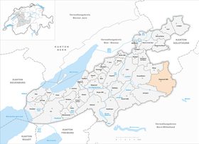
| Location of the municipality | |
  |
|
Rapperswil is a municipality in the Seeland administrative district in the canton of Bern in Switzerland . On January 1, 2016, the municipality merged with Bangerten to form the municipality of Rapperswil / BE .
geography
Rapperswil lies at 521 m above sea level. M. , 13 km north of the canton capital Bern (linear distance). The village in the Swiss Central Plateau covers an easy incident to the north plateau of Rapperswil plateau between the valleys of Limpachtal the north and Lyssbach in the south.
The area of the 18.2 km² municipal area covers a section of the central Bernese plateau. The main part of the community area lies on the Rapperswil plateau, a molasse hill country that was shaped by the Ice Age Rhone glacier and covered with moraine deposits . On the plateau, which is slightly inclined to the north-northwest, arable and meadow land alternate with larger forest areas ( Hardwald , Buechwald ). The plateau is drained by several source streams of the Limpach. The Hohschwerzibach , the Wilbach and the brook from the Buechwald come together at the Rapperswil brickworks and then flow northwards through the Islentäli into the Limpachtal.
To the west, the municipality extends to the Hauenbühl ( 536 m above sea level ), to the north to the heights of Oberholz ( 533 m above sea level ), Gsteig ( 540 m above sea level ), Chrützholz ( 535 m above sea level) . M. ) and Freiholz ( 556 m above sea level ), to the east on the plateau of the Holzacher ( 573 m above sea level ). The southern end of the plateau is formed by the forest heights of Äckenberg ( 614 m above sea level ) and Oberholz (at 623 m above sea level, the highest elevation in Rapperswil). To the south of this, the plateau drops with a relatively steep slope to the depression of the Moossee and Lyssbachtal, the northern half of which in the area between Schüpfen and Münchenbuchsee also belongs to Rapperswil. In 1997, 8% of the municipal area was accounted for by settlements, 29% for forests and woodlands and 63% for agriculture.
Community structure
The municipality of Rapperswil consists of twelve localities:
- Rapperswil ( 521 m above sea level ) in the catchment area of the Wilbach, central place of the municipality, with the hamlet Habanger ( 515 m above sea level ) west of the Wilbach, 634 inhabitants.
- Wierezwil ( 521 m above sea level ) on the plateau west of the Hardwald, with the hamlet of Rüberi ( 523 m above sea level ), 155 inhabitants.
- Frauchwil ( 503 m above sea level ) in the valley of the Hohschwerzibach, 85 inhabitants.
- Zimlisberg ( 527 m above sea level ) on the plateau east of the Islentälis, with the hamlet of Holzhäusern ( 522 m above sea level ), 121 inhabitants.
- Bittwil ( 552 m above sea level ) on the plateau south of the Limpachtal, 70 inhabitants.
- Vogelsang ( 539 m above sea level ) in a cleared island in the Buechwald, 53 inhabitants.
- Seewil ( 554 m above sea level ) on the plateau between Hardwald and Äckenberg, 205 inhabitants.
- Dieterswil ( 562 m above sea level ) on the plateau north of the Äckenberg, 254 inhabitants.
- Moosaffoltern ( 584 m above sea level ) on the plateau south of the Oberholz, above the Moosseetal, 88 inhabitants.
- Lätti ( 540 m above sea level ) on the northern flank of the Moosseetals, 480 inhabitants.
- Ruppoldsried ( 490 m above sea level ) in the Limpachtal, incorporated as of January 1, 2013, 259 inhabitants (2011).
- Bangerten ( 585 m above sea level ) on a hill northeast of the Oberholz, incorporated as of January 1, 2016, 151 inhabitants (2014).
Neighboring communities of Rapperswil are Scheunen , Jegenstorf , Iffwil , Zuzwil (BE) and Deisswil near Münchenbuchsee in the east, Münchenbuchsee and Schüpfen in the south, Grossaffoltern in the west and Wengi in the north, all in the canton of Bern, as well as the Solothurnian Messen in the northeast.
population
With 2,618 inhabitants (as of December 31, 2018), Rapperswil is one of the medium-sized communities in the canton of Bern. 95.4% of the residents are German-speaking, 1.4% French-speaking and 0.7% speak Albanian (as of 2000). The proportion of foreigners is 4.7% (101 inhabitants) and is thus well below the canton's average. 50.6% of the population are male.
The population of Rapperswil was 1987 inhabitants in 1850 and 1681 inhabitants in 1900. In the course of the 20th century the population fluctuated between 1610 and 1780 inhabitants. Since 1980 (1718 inhabitants) a significant increase in population has been recorded again.
politics
Currently (2011) the municipal council consists of representatives of the SVP (4), the SP (1) and the Association for Municipal Politics (VGP) (2).
The voting shares of the parties in the 2019 National Council election were: SVP 42.1%, BDP 12.2%, SP 11.3%, GPS 9.6%, FDP 6.9%, glp 7.8%, EPP 3.2 %, CVP 1.0%, EDU 1.4%.
economy
Until the middle of the 20th century, Rapperswil was primarily a community characterized by agriculture . Even today arable farming , fruit growing , cattle breeding and forestry have an important place in the income structure of the population. There are around 100 farms in the area.
Numerous other jobs are available in local small businesses and in the service sector. The most important employer in Rapperswil is the brickworks Louis Gasser AG, which was founded in 1858 and maintains a large clay and stone quarry north of the village. A commercial zone has developed near Lätti near the A6 motorway. In the community today there are companies in the building trade, the electrical industry, communication technology, mechanical engineering, wood processing and transport. Rapperswil has been the location of a secondary school since 1903. In the last few decades the village has also turned into a residential community. Many workers are therefore commuters who mainly work in the Bern agglomeration .
traffic
The community is very well developed in terms of transport. It is located on the cantonal road from Münchenbuchsee to Büren an der Aare . The closest connection to the A6 motorway (Bern-Biel) is around 3 km from the town center. Rapperswil is connected to the public transport network through a Postbus course , which covers the route from Zollikofen via Büren an der Aare to Solothurn . A train station can also be reached in just 5 minutes by car, it is located in Schüpfen on the Bern - Biel line .
history

The municipality of Rapperswil was settled very early. Evidence of the presence of humans is from the Iron Age (barrows) and from the Roman period (votive stone, brick fragments and foundation walls of a fortification). Two earth castles, one in the valley of the Hohschwerzibach and one in the Zambergwald near Moosaffoltern, have not yet been precisely dated.
The settlement names of Rapperswil and various surrounding villages with the ending -wil point to Alemannic foundations from the 8th to 10th centuries. Rapperswil was first mentioned in writing in 1241 under the name Raverswil . Later the names Raphirswilere (1246), Rapherswilen (1257), Rapfirswile (1260), Raferswiler (1262), Rapherzwile (1342), Rappferswyll (1555), Rapperswyll (1560), Rapperswyl (1653) and Rapperswil (1861). The place name goes back to the Old High German personal name Ratfrid or Ratbrecht and therefore means at the farmstead of Ratfrid / Ratbrecht .
In the Middle Ages, Rapperswil was subordinate to the Counts of Kyburg , who sold their rights over the area to the Frienisberg Monastery in 1263 . The Johanniterkommende Münchenbuchsee and the Cistercian convent Fraubrunnen also owned land on today's parish grounds . Under Bern rule (since the second half of the 14th century) Rapperswil was assigned to the Landvogtei Frienisberg in the Zollikofen district court. In 1505 Rapperswil was raised to the status of a free court, which formed the basis for the emergence of today's community with Rapperswil as the center and the associated nine villages and hamlets.
After the collapse of the Ancien Régime (1798), Rapperswil belonged to the Zollikofen district during the Helvetic Republic and from 1803 to the Aarberg District Office, which received the status of an administrative district with the new cantonal constitution of 1831.
Since January 1, 2010, Rapperswil has been part of the Seeland administrative district. On January 1, 2013, the previously independent municipality of Ruppoldsried and on January 1, 2016, the previously independent municipality of Bangerten was incorporated into Rapperswil.
Attractions
The neo-Gothic church and the former rectory (late 16th century), which were later redesigned several times, are located in the village of Rapperswil . In the garden there is a Roman votive stone dedicated to the god Mercurius . In Rapperswil and in the surrounding villages and hamlets, numerous characteristic farmhouses in the Bernese style from the 17th to 19th centuries have been preserved.
photos

Recording of Volgesang from a balloon

Farmhouse in Vogelsang

Entrance to the village of Moosaffoltern

Farmhouse in Moosaffoltern

Farmhouse in Moosaffoltern with farm dogs
_173.JPG)
_178.JPG)
_002.JPG)
_004.JPG)
_010.JPG)
Web links
- Official website of the municipality of Rapperswil (BE)
- Anne-Marie Dubler : Rapperswil (BE). In: Historical Lexicon of Switzerland .
- Aerial views of the village
Individual evidence
- ↑ Permanent resident population from STAT-TAB of the BfS , municipalities see also regional portraits 2020 on bfs.admin.ch, accessed on May 29, 2020
- ^ Results of the municipality of Rapperswil. State Chancellery of the Canton of Bern, October 20, 2019, accessed on August 17, 2020 .
Aarberg | Arch | Barges | Shaking | Büetigen | Bühl | Büren an der Aare | Diessbach near Büren | Dotzigen | Epsach | Erlach | Dark hens | Gals | Gampelen | Grossaffoltern | Hagneck | Hermigen | Ins | Jens | Kallnach | Kappelen | Leuzigen | Lüscherz | Lyss | Meienried | Merzligen | Müntschemier | Oberwil near Büren | Radelfingen | Rapperswil | Rüti near Büren | Hatching | Seedorf | Siselen | Studen (BE) | Täuffelen | Riding | Tschugg | Vinelz | Walperswil | Wengi | Advertised
Former parishes: Bangerten | Busswil near Büren | Gas ore | Mullen | Niederried near Kallnach | Rubbing | Ruppoldsried
Canton of Bern | Administrative districts of the canton of Bern | Municipalities of the Canton of Bern