Deisswil near Münchenbuchsee
| Deisswil near Münchenbuchsee | |
|---|---|
| State : |
|
| Canton : |
|
| Administrative district : | Bern-Mittelland |
| BFS no. : | 0535 |
| Postal code : | 3053 |
| Coordinates : | 601308 / 209237 |
| Height : | 530 m above sea level M. |
| Height range : | 523-588 m above sea level M. |
| Area : | 2.16 km² |
| Residents: | 86 (December 31, 2018) |
| Population density : | 40 inhabitants per km² |
| Website: | www.deisswil.ch |
|
Deisswil near Münchenbuchsee |
|
| Location of the municipality | |
Deisswil bei Münchenbuchsee is a municipality in the Bern-Mittelland administrative district in the canton of Bern in Switzerland .
geography
Deisswil near Münchenbuchsee lies at 530 m above sea level. M. , 10 km north of the canton capital Bern (beeline). The small village stretches along the northern edge of the Moss Lake Valley at the foot of the heights of Rapperswil plateau on Woolibach , in the Swiss Plateau .
The area of the municipal area of 2.1 km² covers a section of the central Bernese plateau. The southern border runs along the main road from Schönbühl to Schüpfen. From here, the communal soil extends northward over the plain of the roughly 1 km wide Moosseetal and to the adjacent, partially wooded heights of the Rapperswil plateau on both sides of the basin of the Woolibach , a source brook of the Urtenen . To the west of this valley, also called the Urtegraben , is on the Hintel with 581 m above sea level. M. reached the highest point of Deisswil near Münchenbuchsee. To the east, the valley is flanked by Mosenberg ( 561 m above sea level ) and Aspi ( 580 m above sea level ). In 1997, 14% of the municipal area was accounted for by settlements, 24% for forests and woodlands and 62% for agriculture.
Neighboring communities of Deisswil bei Münchenbuchsee are Zuzwil (BE) , Jegenstorf , Wiggiswil , Münchenbuchsee and Rapperswil (BE) .
population
With 86 inhabitants (as of December 31, 2018), Deisswil near Münchenbuchsee is one of the smallest communities in the canton of Bern. 98.9% of the residents speak German and 1.1% speak Serbo-Croatian (as of 2000). The population of Deisswil near Münchenbuchsee was 115 in 1850 and 129 in 1900. In the course of the 20th century, the population decreased by over 40% to 72 people by 1970 due to strong emigration. Since then, only minor population fluctuations have been recorded.
economy
Until the second half of the 20th century, Deisswil near Münchenbuchsee was predominantly an agricultural village. Even today, arable farming , fruit growing and dairy farming have an important place in the income structure of the population. Other jobs are available in the local small business and in the service sector, including in a gravel works that maintains several pits in the municipality. In 2007, a large meat processor was established, which brought over 100 jobs to Deisswil. In 2017, the meat processor doubled its production. This created another 100 jobs. Some employees are commuters who work mainly in Münchenbuchsee and in the Bern agglomeration .
traffic
The community is easily accessible from the main road that connects Schönbühl with Schüpfen . The closest connection to the A6 motorway (Bern-Biel) is around 3 km from the town center. Deisswil near Münchenbuchsee has no connection to the public transport network; There are bus stops and a train station in nearby Münchenbuchsee.
history
The place was first mentioned in a document in 1263 under the name Teiswile . Later the names Teizwile (1264), Theswile (1270), Theisewile (1271) and Tiezwile (1274) appeared. The place name goes back to the Old High German personal name Deizo or Dagizo and therefore means at the Deizo / Dagizo homestead .
Since the Middle Ages, Deisswil near Münchenbuchsee has been under the sovereignty of the Counts of Kyburg . In the 13th century the manor came to the Johanniter Commandery in Münchenbuchsee. Since 1406, sovereignty over the area near Bern was incumbent. After the Commandery had been secularized in 1528, Deisswil near Münchenbuchsee was assigned to the Landvogtei Münchenbuchsee in the Zollikofen district court .
After the collapse of the Ancien Régime (1798), the village belonged to the Zollikofen district during the Helvetic Republic and from 1803 to the Fraubrunnen Oberamt, which received the status of an official district with the new cantonal constitution of 1831. The villages of Deisswil bei Münchenbuchsee and Wiggiswil, which had formed a common school community since 1802, were also united on a political level in 1832. In 1847, however, another separation followed. The cantonal authorities planned a merger again for 1915, but this failed due to resistance from the two communities. Valuable cultivated land was won through the drainage and amelioration of the Moosseetal from 1917 to 1920 and from 1971 to 1984. Today Deisswil near Münchenbuchsee and Wiggiswil have a joint municipal administration and work closely with the large neighboring town of Münchenbuchsee.
Attractions
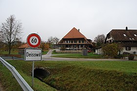
With its stately farmhouses in the Bernese country style from the 18th and 19th centuries, Deisswil near Münchenbuchsee has preserved a place of national importance that is worth protecting. The village does not have its own church, it belongs to the parish of Münchenbuchsee.
Web links
- Official website of the Deisswil community
- Anne-Marie Dubler : Deisswil near Münchenbuchsee. In: Historical Lexicon of Switzerland .
Individual evidence
- ↑ Permanent resident population from STAT-TAB of the BfS , municipalities see also regional portraits 2020 on bfs.admin.ch, accessed on May 29, 2020


