
Sweeping
| Sweeping | |
|---|---|
 |
|
| State : |
|
| Canton : |
|
| Administrative district : | Bern-Mittelland |
| BFS no. : | 0870 |
| Postal code : | 3122 |
| Coordinates : | 602453 / 195402 |
| Height : | 570 m above sea level M. |
| Height range : | 504–777 m above sea level M. |
| Area : | 4.44 km² |
| Residents: | 4305 (December 31, 2018) |
| Population density : | 970 inhabitants per km² |
| Mayor : | Katharina Annen ( FDP ) |
| Website: | www.kehrsatz.ch |
 Sweeping |
|
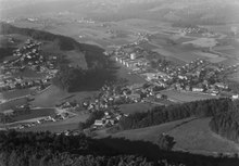
| Location of the municipality | |
  |
|
Kehrsatz (in the Alemannic local dialect Chäsitz [ ˈχæsɪt͡s ]) is a political municipality in the administrative district of Bern-Mittelland in the canton of Bern in Switzerland . It is one of the residential suburbs of the city of Bern.
geography
Kehrsatz is at 570 m above sea level. M. , 4.5 km south-southeast of the canton capital Bern (linear distance). The former clustered village extends in a promising location on a leveled area on the lower eastern slope of the Gurtens and on the northern edge of the Längenberg , above the level of the Belpmoos, which belongs to the broad Aareniederung .
The 4.4 km² municipal area covers a section of the Aare valley between Bern and Thun . The northern border runs along the Aare, into which the Gürbe flows. From here the church floor extends southward on the plateau of Selhofen ( moraine of glacial Aargletschers ), to the slopes of Kehrsatz and into the plane of Belpmooses. The western part of the municipality is occupied by the Gurtentälchen , a valley furrow between the Längenberg and the Gurten, which flows into the Aare valley at Kehrsatz. On the southern flank of the Gurtental is 775 m above sea level. M. reaches the highest point of Kehrsatz on the wooded winter slope. In 1997, 21% of the municipal area was accounted for by settlements, 23% for forests and woodlands and 55% for agriculture; just over 1% was unproductive land.
Kehrsatz includes the residential quarters Untere Gurten , Holzmatt , Tannacher and Stockacher , separated from the old village center , the hamlets Selhofen ( 522 m above sea level ) on the north-western edge of the Belpmoos and Hulistal ( 683 m above sea level ) on a saddle below the Englisbergegg as well some individual farms. Neighboring communities of Kehrsatz are Muri bei Bern , Belp , Wald and Köniz .
population
| Population development | |
|---|---|
| year | Residents |
| 1850 | 466 |
| 1900 | 568 |
| 1930 | 724 |
| 1950 | 971 |
| 1960 | 1195 |
| 1970 | 2773 |
| 1980 | 3658 |
| 1990 | 3795 |
| 2000 | 3710 |
With 4,305 inhabitants (as of December 31, 2018), Kehrsatz is one of the medium-sized municipalities in the canton of Bern. 86.9% of the residents speak German, 2.0% speak French and 1.9% speak Italian (as of 2000). The population of Kehrsatz increased only slowly in the first half of the 20th century. Particularly strong growth rates were recorded during the 1960s and 1970s. Since 1980 there have only been minor population fluctuations. The settlement area of Kehrsatz is growing together with that of the district of Wabern (municipality of Köniz).
politics


Municipal council
The municipal council ( executive ) comprises five part-time members with the municipal presidium , who are elected at the ballot box by the voters of the Kehrsatz municipality according to the principle of proportional representation . Each municipal council has an area of responsibility ( department ).
The local council currently consists of three women and two men. The meetings of the municipal council usually take place every two weeks, with the exception of the holiday season.
| Surname | Area of responsibility | Political party | In the local council since |
|---|---|---|---|
| Katharina Annen |
Municipality President departmental planning and development |
FDP.The Liberals (FDP) | January 1, 2009 |
| Daniel Wägli | Municipal Vice President Finance |
Social Democratic Party (SP) | January 1, 2013 |
| Elisabeth Stalder-Giant | Population and Integration Department | FDP.The Liberals (FDP) | January 1, 2013 |
| Roland Geiger | Construction and Infrastructure | Swiss People's Party (SVP) | April 1, 2015 |
| Claudia Zuber | Education and Youth Department | independent | January 1, 2012 |
| Regula Liechti | Parish clerk |
National elections
The voting shares of the parties in the 2015 National Council elections were: SVP 27.1%, SP 19.2%, FDP 13.0%, BDP 12.3%, glp 6.6%, GPS 6.4%, EPP 5.8 %, EDU 4.0%, CVP 3.5%.
economy
Until the middle of the 20th century, Kehrsatz was a predominantly agricultural village. There used to be a spice mill in the village. After that, it began to develop rapidly into a residential suburb of Bern. Kehrsatz therefore only owns small and medium-sized businesses, but no industry.
Today the community offers around 900 jobs. With 8% of the workforce who are still employed in the primary sector, agriculture (predominantly arable farming , dairy farming and cattle breeding ) still has a certain role in the employment structure of the population. Around 21% of the workforce is employed in the industrial sector, while the service sector accounts for 71% of the workforce (as of 2001).
Various trading and service companies, companies in the building trade, IT, radio and television, a wooden label factory, a mattress factory, mechanical workshops and a company that makes Bernerörgeli are represented in Kehrsatz today. Kehrsatz has been the location of the Selhofen secondary school since 1969.
In the last few decades the village has developed into a residential community. Extensive single and multi-family house quarters were built on the promising eastern slope of the Gurten, in the Gurtentälchen, on the northern slope of the Längenberg and on the plateau near Selhofen. Many employed people are therefore commuters who mainly work in Bern.
traffic
The community has good transport connections. It is located on the main road from Bern to Belp , which has a local bypass in the Kehrsatz area so that the town center is relieved of through traffic. The closest connections to the Swiss motorway network ( A6 , A1 and A12 ) are each around 6 km from the town center.
On August 14, 1901, the Gürbetalbahn (today BLS AG line S3, Biel-Bern-Thun) from Bern to Burgistein (today further to Thun ) was opened with the Kehrsatz station. The Kehrsatz Nord stop was opened later. Just in time for the major timetable change in 2004, the line was expanded to double-lane and both stations were completely rebuilt. The Postbus course , which serves the route from Wabern via Kehrsatz to Niedermuhlern , ensures the fine distribution in public transport . In addition, the Moonliner M5 drives on Thursdays, Fridays, Saturdays and Sundays in the early hours of the morning to drive the party people home.
history
Finds of graves from the Latène period as well as the remains of a Gallo-Roman manor (in Maygut-Breitenacker) indicate an early settlement of the municipality of Kehrsatz. The place was first mentioned in a document in 1270 under the name Cerrisaz . Later the names Kesaz (1277), Kersaz (1281), Kätze (1293), Kersertz (1574) and Chsatz (1577) appeared. The etymology of the place name is unclear.
Since the Middle Ages, Kehrsatz has been under the rule of Belp-Montenach, which came under the sovereignty of Bern as early as 1298 and was assigned to the Bernese district court Seftigen from 1388. In the 15th century, the rule of Kehrsatz developed with its own lower court. In the course of time it experienced numerous changes of ownership (see Kehrsatz Castle ). After the collapse of the Ancien Régime (1798), Kehrsatz belonged to the Seftigen district during the Helvetic Republic and from 1803 to the Seftigen District Office, which received the status of an official district with the new cantonal constitution of 1831.
Kehrsatz achieved Switzerland-wide fame through a murder from 1985, which has not yet been resolved, and especially through the book Mord in Kehrsatz by Hanspeter Born and the trials against the main suspect.
coat of arms
|
|
Blazon : " In blue two golden right-angled bars, accompanied by a golden star at the top " |
| Foundation of the coat of arms: In the 19th century, the Kehrsatz community had the coat of arms of the patrician dulcimer family as the community coat of arms . Karl Hackbrett was the owner of the Kehrsatz rule from 1720 to 1737. The municipality added a gold star to the coat of arms in 1937, and the government council approved the coat of arms in 1945. |
Attractions

The Castle Kehrsatz originally dates from the 14th century but was largely rebuilt in the late 16th century and later remodeled more than once. It has an enclosure wall with a late Gothic tower, which was previously used as a choir prison. From 1888 a girls' education center was set up in the castle; today it serves as a state school home. In addition to the castle, there are various country estates in Kehrsatz that were built by Bernese patrician families. The most important of these is the Lohn estate , an early classicist mansion that was built from 1780 to 1783. In the Campagne Blumenhof , the core of which dates back to the end of the 16th century, but was remodeled in the Baroque style in 1752, the municipal administration of Kehrsatz is now located. Kehrsatz was raised to an independent parish in 1972, before the parish belonged to the parish of Belp . The new ecumenical center with the St. Andrew's Church was built in 1976.
literature
- Hermann von Fischer: The Lohn estate in Kehrsatz BE , Bern 1995.
- Book of arms of the canton of Bern. The Bernese state coat of arms and the coats of arms of the administrative districts and municipalities , published on behalf of the Bernese government council. by the management of the municipalities, arr. from the Bern State Archives with the assistance of Hans Jenni. Armorial du canton de Berne. Les armoiries de l'Etat de Berne, des districts et des communes , publié par la Direction des affaires communales sur mandat du Conseil-exécutif du canton de Berne, élaboré par les Archives de l'Etat de Berne avec la collaboration de Hans Jenni, Bern 1981.
Web links
- Official website of the municipality of Kehrsatz
- Anne-Marie Dubler : Kehrsatz. In: Historical Lexicon of Switzerland .
Individual evidence
- ↑ Permanent resident population from STAT-TAB of the BfS , municipalities see also regional portraits 2020 on bfs.admin.ch, accessed on May 29, 2020
- ^ Community Kehrsatz: Members of the local council
- ↑ Elections 2015: Results of the Kehrsatz community. Canton of Bern, accessed on March 19, 2016.
- ↑ Bern State Archives, documents, Subject Bern Oberamt, June 28, 1270
- ↑ Wappenbuch 1981, p. 184.
- ↑ www.kehrsatz.ch
- ↑ Wappenbuch 1981, p. 184.
Allmendingen | Arni | Bäriswil | Belp | Bern | Biglen | Bolligen | Bowil | Bremgarten near Bern | Brenzikofen | Clavaleyres | Deisswil near Münchenbuchsee | Diemerswil | Ferenbalm | Fraubrunnen | Frauenkappelen | Open-leaved | Gerzensee | Grosshöchstetten | Guggisberg | Gurbrü | Membranous | Herbigen | Iffwil | Ittigen | Jaberg | Jegenstorf | Kaufdorf | Sweep | Gravel | Kirchdorf | Kirchlindach | Köniz | Konolfingen | Kriechenwil | Landiswil | Laupen | Linden | Mattstetten | Meikirch | Mirchel | Moosseedorf | Mühleberg | Münchenbuchsee | Münchenwiler | Münsingen | Muri near Bern | Neuenegg | Niederhünigen | Niedermuhlern | Oberbalm | Oberdiessbach | Oberhünigen | Oberthal | Oppligen | Ostermundigen | Riggisberg | Rubigen | Rüeggisberg | Rümligen | Rüschegg | Schwarzenburg | Stettlen | Thurnen | Toff | Urtenen-Schönbühl | Vechigen | Forest | Walk rings | Wichtrach | Wiggiswil | Wileroltigen | Wohlen near Bern | Worb | Zziwil | Zollikofen | Zuzwil
Former communities: Aeschlen bei Oberdiessbach | Albligen | Ausserbirrmoos | Ball moss | Perch wall | Belpberg | Bleiken near Oberdiessbach | Bremgarten City Court | Bümpliz | Büren to the yard | Englisberg | Etzelkofen | Gelterfingen | Golats | Grafenried | Gysenstein | Hoods | Innerbirrmoos | Church gymnastics | Limpach | Lohnstorf | Mädersforst | Measure barns | Mühledorf | Mill urns | Mülchi | Münchringen | Niederwichtrach | Noflen | Oberscheunen | Oberwichtrach | Otterbach near Oberdiessbach | Rüti near Riggisberg | Shells | Barns | Schlosswil | Schönthal | Stalden in the Emmental | Tägertschi | Trimstone | Electors | Zauggenried | Zimmerwald
Canton of Bern | Administrative districts of the canton of Bern | Municipalities of the Canton of Bern