Münchringen
| Münchringen | ||
|---|---|---|
| State : |
|
|
| Canton : |
|
|
| Administrative district : | Bern-Mittelland | |
| Residential municipality : | Jegenstorf | |
| Postal code : | 3303 | |
| former BFS no. : | 0547 | |
| Coordinates : | 606.31 thousand / 210 352 | |
| Height : | 522 m above sea level M. | |
| Area : | 2.4 km² | |
| Residents: | 566 (December 31, 2007) | |
| Population density : | 236 inhabitants per km² | |
| Website: | www.muenchringen.ch | |
|
Münchringen (1997) |
||
| map | ||
|
|
||
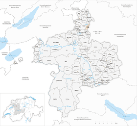
Münchringen was a municipality in the Bern-Mittelland administrative district in the canton of Bern in Switzerland . On January 1, 2014, Münchringen merged with the former municipality of Scheunen to form the municipality of Jegenstorf .
geography
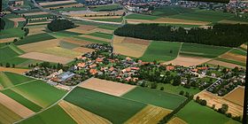
Münchringen lies at 522 m above sea level. M. , twelve kilometers north-northeast of the canton capital Bern (linear distance ). The village is located on a moraine hills east of Urtenen , on the northern edge of the Molassehügellandes between Bern and Emmental , the Swiss Central Plateau .
The area of the municipal area of 2.4 km² covers a section of the central Bernese plateau with only very slight differences in relief. The area is traversed by the channeled and straightened Urtenen from southwest to northeast in a wide valley floor. It extends from Mattenbühl , on which at 529 m above sea level. M. the highest elevation of Münchringen is reached, to the northeast over the hill of Münchringen to the edge of the Hursch forest at Holzmühle. East of the moraine wall of Münchringen is the formerly boggy Turbenmoos basin , to which the moss forest connects. In 1997, 10% of the municipal area was in settlements, 10% in forests and woodlands, 79% in agriculture and a little more than 1% was unproductive land.
The hamlet of Holzmühle ( 508 m above sea level ) on a hill west of the Urten lowlands belongs to Münchringen. Neighboring communities of Münchringen until December 31, 2013 were Zauggenried , Kernenried , Hindelbank , Mattstetten and Jegenstorf .
population
With 1001 inhabitants (as of December 31, 2018) Münchringen is one of the smaller communities in the canton of Bern. 96.3% of the residents are German-speaking, 0.8% French-speaking and 0.8% speak Romansh (as of 2000). The population of Münchringen was 266 in 1850, compared to 198 in 1900. In the course of the 20th century, the population increased only very slowly to 271 people until 1970. Since then (especially during the 1970s) there has been a rapid population increase combined with a doubling of the population within 30 years.
politics
The voting shares of the parties on the occasion of the National Council elections in 2011 were: BDP 21.7%, SP 16.9%, SVP 16.8%, EPP 11.5%, FDP 8.9%, GPS 7.5%, glp 5.5 %, EDU 5.1%, CVP 3.7%.
economy
Up until the second half of the 20th century, Münchringen was a village dominated by agriculture . Thanks to the fertile soils, arable farming , fruit growing and cattle breeding still play an important role in the income structure of the population. Further jobs are available in local small businesses and in the service sector (trustee offices, IT service companies). In Münchringen today there are construction companies, a plasterer business, an interior construction company and a company for sanitary facilities. In the last few decades the village has developed into a residential community. Many workers are therefore commuters who work mainly in the agglomeration of Bern and in the Burgdorf area .
traffic
Although there are no thoroughfares through the village, the community is very well developed in terms of traffic. It is located on a connecting road from Jegenstorf to Hindelbank . The nearest connection to the A1 motorway (Bern-Zurich) is around 5 km from the town center. Münchringen has no direct connection to the public transport network. The nearest train station for the Bern-Solothurn regional train in Jegenstorf is around 1 km away.
history
The first written mention of the place took place in 1261 under the name Munderchingen . Later the names Münrkingen (1300), Munchringen (1312) and Münchingen (1360) appeared. The place name goes back to the Old High German personal name Munderich and therefore means for the people of Munderich .
Since the Middle Ages Münchringen has been under the Count of Kyburg . Since 1406 the village was under the rule of Bern and was assigned to the Zollikofen district court . After the collapse of the Ancien Régime (1798), Münchringen belonged to the Zollikofen district during the Helvetic Republic and from 1803 to the Fraubrunnen Oberamt, which received the status of an official district with the new cantonal constitution of 1831. The hamlet of Holzmühle was not incorporated into Münchringen until 1845.
Attractions
In the old town center of Münchringen, numerous characteristic farmhouses from the 18th and 19th centuries in the Bernese country style have been preserved. The hamlet of Holzmühle also forms a closed group of houses from this period. Münchringen does not have its own church; it belongs to the Jegenstorf-Urtenen parish.
Web links
- Official website of the community of Münchringen
- Anne-Marie Dubler : Münchringen. In: Historical Lexicon of Switzerland .


