Kernenried
| Kernenried | |
|---|---|
| State : |
|
| Canton : |
|
| Administrative district : | Emmental |
| BFS no. : | 0411 |
| Postal code : | 3309 |
| Coordinates : | 608 143 / 213133 |
| Height : | 506 m above sea level M. |
| Height range : | 496-529 m above sea level M. |
| Area : | 3.33 km² |
| Residents: | 553 (December 31, 2018) |
| Population density : | 132 inhabitants per km² |
| Website: | www.kernenried.ch |
|
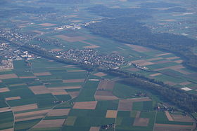
Kernenried (back right; Aefligen in the center of the picture ) |
|
| Location of the municipality | |
Kernenried is a municipality in the Emmental administrative district in the canton of Bern in Switzerland .
geography
Kernenried lies at 506 m above sea level. M. , 6 km west of Burgdorf and 15 km north-northeast of the canton capital Bern (linear distance). The farming village stretches along the southern edge of the flood plain of the Emme , in the valley of Urtenen , east of the hills of Rapperswil plateau in the Swiss Plateau .
The area of the 3.3 km² municipal area covers a section of the Bernese Mittelland. The terrain shows only very minor differences in relief. The western border runs along the canalized Urtenen. From here the municipality extends eastward over the valley and slightly higher gravel terraces to the forest area of Oberholz and Birchiwald , in which at 525 m above sea level. M. the highest point of Kernenried is reached. In the southeast, the main traffic routes of the A1 motorway and the new line of the Bern-Olten railway line ( Bahn 2000 ) form the border for long stretches. In 1997, 11% of the municipal area was in settlements, 25% in forests and woodlands, 63% in agriculture and a little less than 1% was unproductive land.
Kernenried consists of the districts of Oberdorf ( 506 m above sea level ) and Unterdorf (also called Chappeli ; 502 m above sea level ) and some individual farms. Neighboring communities of Kernenried are Fraubrunnen , Lyssach , Hindelbank , Münchringen and Zauggenried .
population
With 553 inhabitants (as of December 31, 2018), Kernenried is one of the small communities in the canton of Bern. 98.0% of the residents speak German, 0.9% speak Macedonian and 0.2% speak French (as of 2000). The population of Kernenried was 331 in 1850 and 349 in 1900. In the course of the 20th century, the population always fluctuated between 300 and 340 people. Since 1980 (307 inhabitants) there has been a significant increase in population.
politics
The voting shares of the parties in the 2019 National Council election were: SVP 45.0%, BDP 12.3%, glp 11.6%, GPS 10.9%, SP 8.8%, FDP 4.8%, EPP 1.3 %, CVP 0.9%, SD 0.9%.
economy
Until the second half of the 20th century, Kernenried was a village dominated by agriculture . Even today, the have farming , the fruit-growing and cattle breeding an important role in the employment structure of the population. Further jobs are available in local small businesses and in the service sector, including in a horticultural company and in a saddlery. In the last few decades the village has developed into a residential community. Many employees are therefore commuters who work mainly in the Burgdorf region and in the agglomeration of Bern.
traffic
The community is located off the major thoroughfares on a connecting road from Burgdorf to Fraubrunnen. The closest connection to the A1 motorway (Bern-Zurich) is around 3 km from the town center. Kernenried is connected to the public transport network by a bus line operated by Regionalverkehr Mittelland AG , which serves the route from Burgdorf to Fraubrunnen.
history
The community area of Kernenried was inhabited very early, which was proven by the discovery of burial mounds from the Hallstatt period in Oberholz and a Roman coin deposit. The first written mention of the place took place in 1261 under the name Reide . Later the names Kerrenriet (1318), Riede (1321), Kärrenriet (1329) and Kernenriet (1380) appeared. The place name goes back to the Old High German word (h) riot (reed grass). To distinguish it from other villages with the same name, the name of the knight family Kerren was added.
Since the Middle Ages , Kernenried was the ancestral seat of the Lords of Kerren, whose moated castle was in the Mösli. The Kerren family was a ministerial dynasty of the Counts of Kyburg . Their castle was destroyed by the Bernese in 1318; no remains are visible today. The rulership changed through a marriage to the Bernese family von Erlach, from 1579 it belonged to the upper hospital in Bern. When Kernenried came under the sovereignty of the Bernese in 1406, it was assigned to the Zollikofen district court . After the collapse of the Ancien Régime (1798), the village belonged to the Burgdorf district during the Helvetic period and from 1803 to the Burgdorf Oberamt, which received the status of an official district with the new cantonal constitution of 1831.
Up until the Reformation, Kernenried had a chapel (hence the name Chappeli for the lower village), since then it has belonged to the Kirchberg parish .
See also
Web links
- Official website of the municipality of Kernenried
- Anne-Marie Dubler : Kernenried. In: Historical Lexicon of Switzerland .
Individual evidence
- ↑ Permanent resident population from STAT-TAB of the BfS , municipalities see also regional portraits 2020 on bfs.admin.ch, accessed on May 29, 2020
- ↑ Results of the community of Kernenried. State Chancellery of the Canton of Bern, October 20, 2019, accessed on July 30, 2020 .


