
Clairvoyant
| Clairvoyant | |
|---|---|
 |
|
| State : |
|
| Canton : |
|
| Administrative district : | Emmental |
| BFS no. : | 0408 |
| Postal code : | 3429 |
| Coordinates : | 615907 / 221796 |
| Height : | 478 m above sea level M. |
| Height range : | 462-577 m above sea level M. |
| Area : | 1.48 km² |
| Residents: | 211 (December 31, 2018) |
| Population density : | 122 inhabitants per km² |
| Website: | www.hellsau.ch |
_286.JPG) Entrance of Hellsau on the main road No. 1 coming from Höchstetten |
|
| Location of the municipality | |
  |
|
Hellsau is a municipality in the Emmental administrative district in the canton of Bern in Switzerland .
geography
Hellsau lies at 478 m above sea level. M. , 6 km southwest of Herzogenbuchsee and 10 km north of the city of Burgdorf (linear distance). The farming village extends slightly increased at the northern foot of the large timber in the valley of at Lifelen in Rümlig opens Chrümelbachs , east of the flood plain of the Emme , in the Swiss Plateau .
The area of 1.5 square kilometers large municipal territory includes a portion of the glacial Rhone glacier over-molded Molassehöhen east of Emmeebene in Bernese Midlands. The northern border runs along the canalized Chrümelbach , a right side stream of the Ösch . From here, the municipality extends southwards over the flat valley and the slope of Hellsau to the Großholz , on which at 571 m above sea level. M. the highest elevation of Hellsau is reached. The short erosion valley of the Dorfbach is deepened into this molasse height. In 1997, 8% of the municipal area was accounted for by settlements, 24% by forests and woodlands and 68% by agriculture.
The two outlying settlements Mösli ( 470 m above sea level ) to the west and Freienhof ( 480 m above sea level ) to the east of the village, both located at the northern foot of the Großholzes, belong to Hellsau . Neighboring communities of Hellsau are Seeberg , Alchenstorf and Höchstetten in the canton of Bern and Drei Höfe in the canton of Solothurn .
population
With 211 inhabitants (as of December 31, 2018), Hellsau is one of the smallest communities in the canton of Bern. 97.9% of the residents speak German, 0.5% French and 0.5% speak Dutch (as of 2000). The population of Hellsau was 216 inhabitants in 1850 and 210 inhabitants in 1900. In the course of the 20th century, the population decreased by almost 35% to 138 people by 1970 due to strong emigration. Since then, a slight increase in population has been recorded.
politics
Hellsau is recorded in the electoral archive of the canton of Bern together with its neighboring municipality of Höchstetten BE .
The voting shares of the parties in the 2019 National Council election were: SVP 60.6%, BDP 10.6%, SP 6.9%, GPS 5.2%, glp 4.8%, FDP 3.7%, EVP 1.5 %.
economy
Until the second half of the 20th century, Hellsau was primarily an agricultural village. Even today arable farming , fruit growing and cattle breeding have a certain place in the income structure of the population. Further jobs are available in local small businesses and in the service sector. The school building of the communities of Hellsau and Höchstetten has been located in the Mösli since 1820; a new building was built in 1976. In the last few decades the village has developed into a residential community. Many workers are therefore commuters who work mainly in the Langenthal-Herzogenbuchsee region and in the Solothurn area .
traffic
The community is located on Hauptstrasse 1 from Bern to Zurich . The nearest connection to the A1 motorway (Bern-Zurich) is around 7 km from the town center. Apart from the night bus M12 from Bern to Langenthal or Wangen an der Aare on the nights from Friday to Saturday and Saturday to Sunday, Hellsau has no connection to the public transport network.
history
Graves from the early Middle Ages were found in the municipality . The place was first mentioned in a document in 1275 under the name Hellesowe . Later the names Heilsow (1353), Hellsowa (1377), Helsauw (1724) and Hellsau (1838) appeared. The place name goes back to the Old High German personal name Heilo or Hello and means something like Au belonging to Heilo / Hello .
Hellsau has belonged to the Koppigen rule since the Middle Ages . After the Lords of Koppigen died out in the 14th century, Hellsau came to the Thorberg rule and in 1397 to the Thorberg Charterhouse. From 1275 until the time of the Reformation, the village had a church; since then it has been subordinate to the parish of Koppigen. In 1528 the village came under the rule of Bern and was assigned to the Landvogtei Wangen and the Koppigen court district.
After the collapse of the Ancien Régime (1798), Hellsau belonged to the district of Wangen during the Helvetic Republic and from 1803 to the Oberamt Burgdorf, which received the status of an official district with the new cantonal constitution of 1831. From 1943 to 1948 the former swampy valley low of the Chrümelbach was subjected to an amelioration and new cultivated land was gained.
photos

Freienhof
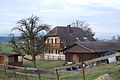
Residential building in Freienhof, Hellsau

Welcome board at the entrance to the village
_274.JPG)
_277.JPG)
_259.JPG)
See also
Web links
- Official website of the municipality of Hellsau
- Anne-Marie Dubler : Hellsau. In: Historical Lexicon of Switzerland .
Individual evidence
- ↑ Permanent resident population from STAT-TAB of the BfS , municipalities see also regional portraits 2020 on bfs.admin.ch, accessed on May 29, 2020
- ↑ Results of the communities of Hellsau and Höchstetten. State Chancellery of the Canton of Bern, October 20, 2019, accessed on July 30, 2020 .
Aefligen | Affoltern im Emmental | Alchenstorf | Bätterkinden | Burgdorf | Dürrenroth | Eggiwil | Ersigen | Hasle near Burgdorf | Heimiswil | Hellsau | Hindelbank | Höchstetten | Kernenried | Kirchberg | Koppigen | Krauchthal | Langnau im Emmental | Lauperswil | Lützelflüh | Lyssach | Mötschwil | Oberburg | Röthenbach im Emmental | Rüderswil | Rüdtligen-Alchenflüh | Rüegsau | Rumendingen | Rüti near Lyssach | Schangnau | Signau | Sumiswald | Trachselwald | Trub | Trubschachen | Utzenstorf | Wiler near Utzenstorf | Willadingen | Wynigen | Zielebach
Former parishes: Bärau | Bickigen-Schwanden | Crusher houses | Niederösch | Oberösch | Wil at Koppigen
Canton of Bern | Administrative districts of the canton of Bern | Municipalities of the Canton of Bern