
Rüdtligen-Alchenflüh
| Rüdtligen-Alchenflüh | |
|---|---|
 |
|
| State : |
|
| Canton : |
|
| Administrative district : | Emmental |
| BFS no. : | 0420 |
| Postal code : | 3422 |
| Coordinates : | 610 883 / 214867 |
| Height : | 505 m above sea level M. |
| Height range : | 497-517 m above sea level M. |
| Area : | 2.72 km² |
| Residents: | 2418 (December 31, 2018) |
| Population density : | 889 inhabitants per km² |
| Mayor : | Friedrich Jöhr (OPRA) |
| Website: | www.ruedtligen-alchenflueh.ch |
_154.jpg) Aerial view of Rüdtligen-Alchenflüh from a balloon, taken on April 16, 2011 |
|
| Location of the municipality | |
  |
|
Rüdtligen-Alchenflüh is a municipality in the Emmental administrative district in the canton of Bern in Switzerland . Until 1926 the official name of the community was Rüdtligen .
geography
Rüdtligen-Alchenflüh lies at 505 m above sea level. M. , 5 km northwest of the city of Burgdorf (linear distance). The village extends in the southern part of the wide alluvial plain of the Emme , on the left side of the river across from Kirchberg (BE), in the Swiss plateau .
The area of the municipal area of 2.7 km² covers a section of the central Bernese plateau and has practically no differences in relief. The canalised and straightened course of the Emme forms the north-eastern border. From here the municipality extends to the southwest over the flat land of the intensely agriculturally used Emme plain to the edge of the Fraubrunnen-Rüdtligen forest. The highest elevation of Rüdtligen-Alchenflüh is 511 m above sea level. M. reached on the southern edge of the municipality. In 1997, 26% of the municipal area was in settlements, 5% in forests and woodlands, 67% in agriculture and a little more than 2% was unproductive land.
The community consists of the two districts of Alchenflüh ( 510 m above sea level ) on the left side of the Emme opposite Kirchberg and Rüdtligen ( 505 m above sea level ), a rural village west of the autobahn with some beautiful old farmhouses and larger housing estates . Neighboring communities of Rüdtligen-Alchenflüh are Kirchberg (BE) , Lyssach , Fraubrunnen and Aefligen .
population
With 2,418 inhabitants (as of December 31, 2018), Rüdtligen-Alchenflüh is one of the medium-sized communities in the canton of Bern. Of the residents, 85.2% speak German, 3.8% speak Italian and 2.3% speak Albanian (as of 2000). The population of Rüdtligen-Alchenflüh was 476 in 1850, and 518 in 1900. By 1960 the population had doubled to 1,027 people. Since then, the population has doubled again, with the greatest growth rates being observed during the 1970s.
politics
The voting shares of the parties in the 2019 National Council election were: SVP 43.5%, SP 10.5%, BDP 10.0%, FDP 8.9%, GPS 9.9%, glp 7.8%, EVP 2.7 %, CVP 1.4%, EDU 0.7%, pirates 0.6%.
economy
Until the second half of the 20th century, Rüdtligen-Alchenflüh was predominantly an agricultural community. Today agriculture , fruit growing and cattle breeding have only a minor role in the income structure of the population. Numerous other jobs are available in the commercial and service sectors. In Alchenflüh in particular, larger commercial and industrial zones have emerged near the train station and on the edge of the village. In Rüdtligen-Alchenflüh today there are horticultural, construction, food industry (including Emmi Käse AG) and mechanical workshops represented. In the last few decades the village has also developed into a residential community. Many employees are therefore commuters who work mainly in the Burgdorf region and in the agglomeration of Bern . On November 21, 2006, the furniture specialist Conforama was opened in the municipality of Rüdtligen-Alchenflüh. A Coop petrol station with a shop and a Burger King restaurant have been open since December 15, 2006. The Pfister furniture store opened on March 1, 2007. This means that around 500 jobs will be offered in the region around the motorway exit in Alchenflüh alone.
traffic
The community has excellent transport connections. It is located on main road 1 from Bern to Zurich , from which main road 23 branches off to Burgdorf and into the Emmental . The Kirchberg junction to the A1 motorway (Bern-Zurich) is located in the municipality , around 1 km from the town center. On May 26, 1875, the railway line from Burgdorf to Solothurn was opened with the Kirchberg-Alchenflüh station (in the area of Alchenflüh). The BLS S-Bahn station and the quarter-hour bus connection in the direction of Burgdorf offer the residents of the Rüdtligen-Alchenflüh community excellent public transport connections.
history
The first incorrectly proven mention of Rüdtligen-Alchenflüh goes back to 894 AD. Later, the names Rüdelingen (1261), Rüdlingen (1275), Rütlingen (1303), Rüttlingen (1582) and Rüedligen (1783) appeared for Rüdtligen . The place name goes back to the Old High German personal name Hrodilo or Ruodilo and therefore means for the people of Hrodilo / Ruodilo . Alchenflüh is mentioned in the documents in 1389 as Alfenflün , 1409 as Alchenflu and 1579 as Allchaflü . This name goes back to the Old High German personal name Alcher or Alker and means for the Flüh des Alcher , which means the sandstone cliffs near Kirchberg.
Probably already at the time of the Kingdom of Hochburgund the place was an important place of justice ( under the Saarbaum zu Alchenflüh ) in the region. In the High Middle Ages , Rüdtligen and Alchenflüh belonged to the royal court of Kirchberg. Later the villages were under the sovereignty of the Zähringer and from the 13th century under that of the Kyburger . Under the rule of Bern (since 1406) Alchenflüh continued to be a place of jurisdiction, which was initially subordinate to the Landvogtei Wangen and from 1471 to the mayor's office in Burgdorf. After the collapse of the Ancien Régime (1798), Rüdtligen and Alchenflüh belonged to the Burgdorf district during the Helvetic Republic and from 1803 to the Burgdorf Oberamt, which received the status of an official district with the new cantonal constitution of 1831. Alchenflüh has belonged to the political municipality of Rüdtligen since 1833.
By resolution of the community on November 8, 1926, the community name was changed from Rüdtligen to Rüdtligen-Alchenflüh. A consultative vote carried out in 1973 on a merger between Rüdtligen-Alchenflüh and Kirchberg was rejected. Since it opened in 1965, the A1 motorway has divided the districts of Rüdtligen and Alchenflüh. As part of the construction of the new railway line from Bern to Olten ( Bahn 2000 ), the motorway was also relocated to an open-cast tunnel by 2001, which raised the quality of living in the villages and created a new leisure space. The center of Alchenflüh was also freed from through traffic by the Kirchberg-Alchenflüh relief road.
Attractions
In the Rüdtligen district, some characteristic farmhouses in the Bernese country style from the 18th and 19th centuries have been preserved. Rüdtligen-Alchenflüh does not have its own church, it belongs to the Kirchberg parish. The cover of the motorway was expanded into a meeting place (skater track, barbecue areas, tables, benches, arcade, etc.). Behind it is the Schmittebächli area with a large pond as an ecological compensation area for Bahn 2000.
In the chicory halls in Alchenflüh, which was demolished in 2010 , the Burgdorf-born director Franz Schnyder set up the studios of his company Neue Film AG and made several of his famous Gotthelf films there .
Alchenflüh sign
Rüdtligen town sign

Motorway coverage
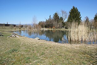
Renaturation

Shopping mile

Shopping mile


_040.jpg)
Personalities
- Michel Wehner (* 1964), Swiss clairvoyant, better known under his pseudonym Mike Shiva
Web links
- Official website of the municipality of Rüdtligen-Alchenflüh
- Anne-Marie Dubler : Alchenflüh. In: Historical Lexicon of Switzerland .
- Anne-Marie Dubler: Rüdtligen-Alchenflüh. In: Historical Lexicon of Switzerland .
Individual evidence
- ↑ Permanent resident population from STAT-TAB of the BfS , municipalities see also regional portraits 2020 on bfs.admin.ch, accessed on May 29, 2020
- ↑ Results of the community Rüdtligen-Alchenflüh. State Chancellery of the Canton of Bern, October 20, 2019, accessed on July 31, 2020 .
- ↑ Website of the community of Rüdtligen-Alchenflüh ( memento of the original from April 10, 2009 in the Internet Archive ) Info: The archive link has been inserted automatically and has not yet been checked. Please check the original and archive link according to the instructions and then remove this notice. , accessed October 20, 2010
Aefligen | Affoltern im Emmental | Alchenstorf | Bätterkinden | Burgdorf | Dürrenroth | Eggiwil | Ersigen | Hasle near Burgdorf | Heimiswil | Hellsau | Hindelbank | Höchstetten | Kernenried | Kirchberg | Koppigen | Krauchthal | Langnau im Emmental | Lauperswil | Lützelflüh | Lyssach | Mötschwil | Oberburg | Röthenbach im Emmental | Rüderswil | Rüdtligen-Alchenflüh | Rüegsau | Rumendingen | Rüti near Lyssach | Schangnau | Signau | Sumiswald | Trachselwald | Trub | Trubschachen | Utzenstorf | Wiler near Utzenstorf | Willadingen | Wynigen | Zielebach
Former parishes: Bärau | Bickigen-Schwanden | Crusher houses | Niederösch | Oberösch | Wil at Koppigen
Canton of Bern | Administrative districts of the canton of Bern | Municipalities of the Canton of Bern