
Willadingen
| Willadingen | |
|---|---|
 |
|
| State : |
|
| Canton : |
|
| Administrative district : | Emmental |
| BFS no. : | 0423 |
| Postal code : | 3425 |
| Coordinates : | 613 358 / 221604 |
| Height : | 465 m above sea level M. |
| Height range : | 458-520 m above sea level M. |
| Area : | 2.17 km² |
| Residents: | 205 (December 31, 2018) |
| Population density : | 87 inhabitants per km² |
| Website: | www.willadingen.ch |
_339.JPG) Willadingen |
|
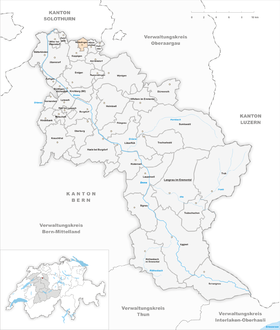
| Location of the municipality | |
  |
|
Willadingen is a municipality in the Emmental administrative district in the canton of Bern in Switzerland .
geography
Willadingen lies at 465 m above sea level. M. , 10 km north of the city of Burgdorf and 9 km southeast of Solothurn (as the crow flies). The scattered village extends to a side channel of the Ösch that here between two moraine hills passes, on the eastern edge of the flood plain of the Emme , in the Swiss Plateau .
The area of the 2.2 km² municipal area covers a section of the Bernese Mittelland. The northern part of the municipality lies in the flat, agriculturally intensively used Emme plain and extends into the Neumatt and Moosmatt corridors as well as the Chrümelbach (right tributary of the Ösch). In the east the alder forest belongs to Willadingen. To the south, the municipality extends to the moraine hills Schuelwald ( 490 m above sea level ), Fänglenberg (at 519 m above sea level, the highest elevation in Willadingen) and the Mösli plateau in front of it, formed by the Ice Age Rhone glacier . The Ösch valley is located between Schuelwald and Fänglenberg. In 1997, 6% of the municipal area was in settlements, 27% in forests and woodlands, 66% in agriculture and a little less than 1% was unproductive land.
The Mösli farm group ( 490 m above sea level ) on a plateau west of the Fänglenberg belongs to Willadingen. Neighboring communities of Willadingen are Höchstetten and Koppigen in the canton of Bern and Recherswil and Drei Höfe in the canton of Solothurn .
population
With 205 inhabitants (as of December 31, 2018) Willadingen is one of the smallest communities in the canton of Bern. 98.8% of the residents speak German, 0.6% speak English and 0.6% speak Portuguese (as of 2000). The population of Willadingen was 141 inhabitants in 1850, 198 inhabitants in 1900. In the course of the 20th century, the population fluctuated between 180 and 260 inhabitants and has shown a slight increase in recent years.
Willadingen has not had its own municipal administration since the 1950s; these services are purchased from the neighboring municipality of Koppigen. Willadingen also has no schools of its own. The lower level (primary school), the upper level (junior high and secondary school) and the kindergarten are part of the regional community association with the member communities Alchenstorf, Hellsau, Höchstetten, Koppigen and Willadingen.
politics
The voting shares of the parties in the 2019 National Council election were: SVP 60.5%, BDP 9.5%, SP 8.2%, glp 7.9%, GPS 5.5%, FDP 4.7%, EVP 1.0 %, EDU 0.8%, CVP 0.4%.
economy
Until the second half of the 20th century, Willadingen was predominantly an agricultural village. Even today, arable farming , dairy farming , cattle breeding and the use of forests play an important role in the livelihood structure of local agriculture and give the village its rural character. Some other jobs are in local small businesses and in the service sector. In the last few decades the village has developed into a residential community. The majority of those in employment are therefore commuters who work mainly in the larger localities in the area (in the Burgdorf, Bern and Solothurn area).
traffic
The community is located away from the major thoroughfares; the main access is from Koppigen or Höchstetten . The nearest connection to the A1 motorway (Bern-Zurich) is around 7 km from the town center. With the regional citizen bus, Willadingen has a direct connection to the public transport network in Koppigen.
history
The first written mention of the place took place in 1259 under the name Wielanding . Later the names Wilandingen (1273), Willedingen (1274) and Wiladingen (1367) appeared. The place name goes back to the Old High German personal name Willihad and therefore means for the people of Willihad .
Willadingen has belonged to the Koppigen rule since the Middle Ages . After the Lords of Koppigen died out in the 14th century, Willadingen came to the Thorberg rule and in 1397 to the Thorberg Charterhouse. In 1528 the village came under the rule of Bern and was assigned to the Landvogtei Wangen and the Koppigen court district. After the collapse of the Ancien Régime (1798), Willadingen belonged to the district of Wangen during the Helvetic Republic and from 1803 to the Oberamt Burgdorf, which received the status of an official district with the new cantonal constitution of 1831.
Attractions
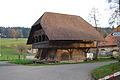
The core zone of Willadingen is one of the sites of national importance worth protecting. In the center there are numerous characteristic farmhouses in the Bernese country style from the 17th to the 20th century with the associated Stöckli (residential houses of the old farmers) and farm gardens, as well as the granaries, some of which are built over the village stream. Willadingen does not have its own church; the community belongs to the Koppigen parish.
photos

Wood storage on the Ösch canal

Farmhouse (right) with Stöckli in the town center
Wood storage dated 1784
_329.JPG)
_328.JPG)
_319.JPG)
Web links
- Official website of the municipality of Willadingen
- Anne-Marie Dubler : Willadingen. In: Historical Lexicon of Switzerland .
Individual evidence
- ↑ Permanent resident population from STAT-TAB of the BfS , municipalities see also regional portraits 2020 on bfs.admin.ch, accessed on May 29, 2020
- ^ Results of the Willadingen community. State Chancellery of the Canton of Bern, October 20, 2019, accessed on August 3, 2020 .
Aefligen | Affoltern im Emmental | Alchenstorf | Bätterkinden | Burgdorf | Dürrenroth | Eggiwil | Ersigen | Hasle near Burgdorf | Heimiswil | Hellsau | Hindelbank | Höchstetten | Kernenried | Kirchberg | Koppigen | Krauchthal | Langnau im Emmental | Lauperswil | Lützelflüh | Lyssach | Mötschwil | Oberburg | Röthenbach im Emmental | Rüderswil | Rüdtligen-Alchenflüh | Rüegsau | Rumendingen | Rüti near Lyssach | Schangnau | Signau | Sumiswald | Trachselwald | Trub | Trubschachen | Utzenstorf | Wiler near Utzenstorf | Willadingen | Wynigen | Zielebach
Former parishes: Bärau | Bickigen-Schwanden | Crusher houses | Niederösch | Oberösch | Wil at Koppigen
Canton of Bern | Administrative districts of the canton of Bern | Municipalities of the Canton of Bern