
Höchstetten BE
| BE is the abbreviation for the canton of Bern in Switzerland and is used to avoid confusion with other entries of the name Höchstetten . |
| Höchstetten | |
|---|---|
 |
|
| State : |
|
| Canton : |
|
| Administrative district : | Emmental |
| BFS no. : | 0410 |
| Postal code : | 3429 |
| Coordinates : | 614 642 / 221 453 |
| Height : | 480 m above sea level M. |
| Height range : | 458-567 m above sea level M. |
| Area : | 2.64 km² |
| Residents: | 275 (December 31, 2018) |
| Population density : | 104 inhabitants per km² |
| Website: | www.hoechstetten.ch |
_310.JPG) Höchstetten BE |
|
| Location of the municipality | |
  |
|
Höchstetten is a municipality in the Emmental administrative district in the canton of Bern in Switzerland .
geography
Höchstetten is 480 m above sea level. M. , 7 km southwest of Herzogenbuchsee and 10 km north of the city of Burgdorf (linear distance). The farming village extends slightly higher at the northwest foot of the Grossholzes in the valley of the Chrümelbach , east of the alluvial plain of the Emme , in the Swiss plateau .
The area of the community area of 2.6 km² comprises a section of the Molasse heights east of the Emme level in the Bernese Mittelland, which was shaped by the Ice Age Rhone glacier . The northern part of the municipality is taken up by the wide valley of the Chrümelbach , which flows out into the Emme plain, and the moraine height of Breiti . In the west, the edge of the forest at the height of Gross Fänglenberg forms the border. The hollow between the Fänglenberg and the Grossholz also belongs to the community. To the southeast, the municipality extends over the gently rising slope to the broad ridge of the large wood, on which at 563 m above sea level. M. the highest point of Höchstetten is reached. In 1997, 6% of the municipal area was in settlements, 20% in forests and woodlands, 73% in agriculture and a little more than 1% was unproductive land.
Neighboring communities of Höchstetten are Hellsau , Alchenstorf , Koppigen and Willadingen in the canton of Bern and Drei Höfe in the canton of Solothurn .
population
With 275 inhabitants (as of December 31, 2018) Höchstetten is one of the small communities in the canton of Bern. 98.0% of the residents speak German and 0.8% speak French (as of 2000). The population of Höchstetten was 252 in 1850 and 299 in 1900. In the course of the 20th century, the population decreased by 25% to 223 people by 1980 due to strong emigration. Since then, a slight increase in population has been recorded.
politics
Höchstetten is recorded in the electoral archive of the Canton of Bern together with its neighboring municipality of Hellsau BE .
The voting shares of the parties in the 2019 National Council election were: SVP 60.6%, BDP 10.6%, SP 6.9%, GPS 5.2%, glp 4.8%, FDP 3.7%, EVP 1.5 %.
economy
Until the second half of the 20th century, Höchstetten was predominantly an agricultural village. Even today, the have farming , the fruit-growing and cattle breeding an important role in the employment structure of the population. Further jobs are available in local small businesses and in the service sector, including in an electrical engineering company and in a body shop. In the last few decades the village has developed into a residential community. Many workers are therefore commuters who work mainly in the Langenthal-Herzogenbuchsee region and in the Solothurn area .
traffic
The community is located on Hauptstrasse 1 from Bern to Zurich . The nearest connection to the A1 motorway (Bern-Zurich) is around 6 km from the town center. Höchstetten has no connection to the public transport network.
history
Some stray finds were discovered in the municipality of Höchstetten, which testify to the presence of humans as early as the Mesolithic and Neolithic . The place was first mentioned in documents in 1360 under the name Hönstetten ; from 1404 the name Höstetten has been handed down. The place name goes back to the Old High German personal name Huno and therefore means in the Huno residences .
Höchstetten has belonged to the Koppigen rule since the Middle Ages . After the Lords of Koppigen died out in the 14th century, Höchstetten came to the Thorberg rule and in 1397 to the Thorberg Charterhouse. In 1528 the village came under the rule of Bern and was assigned to the Landvogtei Wangen and the Koppigen court district.
After the collapse of the Ancien Régime (1798) Höchstetten belonged to the district of Wangen during the Helvetic Republic and from 1803 to the Oberamt Burgdorf, which was given the status of an official district with the new cantonal constitution of 1831. The village does not have its own church, it belongs to the Koppigen parish.
photos

Commercial district on Hauptstrasse 1
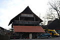
Holzstadel

Entrance to the town on Hauptstrasse 1 coming from Hellsau

Traditional Emmental house
_295.JPG)
_302.JPG)
_290.JPG)
_303.JPG)
See also
Web links
- Official website of the municipality of Höchstetten
- Anne-Marie Dubler : Höchstetten. In: Historical Lexicon of Switzerland .
Individual evidence
- ↑ Permanent resident population from STAT-TAB of the BfS , municipalities see also regional portraits 2020 on bfs.admin.ch, accessed on May 29, 2020
- ↑ Results of the communities of Hellsau & Höchstetten. State Chancellery of the Canton of Bern, October 20, 2019, accessed on July 30, 2020 .
Aefligen | Affoltern im Emmental | Alchenstorf | Bätterkinden | Burgdorf | Dürrenroth | Eggiwil | Ersigen | Hasle near Burgdorf | Heimiswil | Hellsau | Hindelbank | Höchstetten | Kernenried | Kirchberg | Koppigen | Krauchthal | Langnau im Emmental | Lauperswil | Lützelflüh | Lyssach | Mötschwil | Oberburg | Röthenbach im Emmental | Rüderswil | Rüdtligen-Alchenflüh | Rüegsau | Rumendingen | Rüti near Lyssach | Schangnau | Signau | Sumiswald | Trachselwald | Trub | Trubschachen | Utzenstorf | Wiler near Utzenstorf | Willadingen | Wynigen | Zielebach
Former parishes: Bärau | Bickigen-Schwanden | Crusher houses | Niederösch | Oberösch | Wil at Koppigen
Canton of Bern | Administrative districts of the canton of Bern | Municipalities of the Canton of Bern