
Ersigen
| Ersigen | |
|---|---|
 |
|
| State : |
|
| Canton : |
|
| Administrative district : | Emmental |
| BFS no. : | 0405 |
| Postal code : | 3423 Ersigen 3424 Niederösch 3424 Oberösch |
| Coordinates : | 611809 / 215 641 |
| Height : | 500 m above sea level M. |
| Height range : | 479–618 m above sea level M. |
| Area : | 15.46 km² |
| Residents: | 2068 (December 31, 2018) |
| Population density : | 134 inhabitants per km² |
| Website: | www.ersigen.ch |
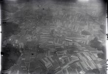
 Plain between Rudswil and Oberösch |
|
| Location of the municipality | |
  |
|
Ersigen is a municipality in the Emmental administrative district in the canton of Bern in Switzerland .
geography
Ersigen is 500 m above sea level. M. , 5 km north-northwest of the city of Burgdorf (linear distance). The former road and stream line the village stretches along the Ösch , on the eastern edge of the flood plain of the Emme and Molassehöhe of the foot Loberges , in the Swiss Plateau .
The area of the 8.8 km² municipal area covers a section of the central Bernese plateau. The western half of the area lies in the flat Emme plain (on average at 495 m above sea level ) with the plateaus of Furtrain ( 508 m above sea level ) and Aspli ( 505 m above sea level ). In the extreme west, the traffic axes of the A1 motorway and the railway form the border. The Ösch, which drains the entire area, emerges from the Molasse heights into the plain at Ersigen, but here describes a sharp bend and flows north along the eastern edge of the plain.
To the east, the municipality extends into the undulating and predominantly wooded Molasse hill landscape, which was once shaped by the Ice Age Rhone glacier . Ersigen includes the Loberg ( 580 m above sea level ), the Tannwald ( 597 m above sea level ), the Längenberg ( 597 m above sea level ), the Allmend (at 618 m above sea level, the highest elevation of Ersigen) and the Reiteggwald ( 601 m above sea level ). Between the latter two is the Erlimoostal , which is drained to the east to the Chänerechbach (tributary of the Ösch). In 1997, 10% of the municipal area was accounted for by settlements, 32% for forests and woodlands and 58% for agriculture.
Ersigen includes the hamlet of Rudswil ( 494 m above sea level ) on the right of the Ösch on the eastern edge of the Emme level, extensive residential quarters on the southern slope of the Loberge and a few individual farms. Neighboring communities of Ersigen are Koppigen , Alchenstorf , Rumendingen , Kirchberg (BE) and Utzenstorf .
population
With 2068 inhabitants (as of December 31, 2018) Ersigen is one of the smaller communities in the canton of Bern. 95.8% of the residents speak German, 1.0% speak Serbo-Croatian and 0.8% speak Albanian (as of 2000). The population of Ersigen was 1149 inhabitants in 1850 and 1113 in 1900. In the course of the 20th century, the population slowly increased to 1,354 people by 1970. After a temporary phase of stagnation, the population has increased again since 1990.
politics
The voting shares of the parties on the occasion of the National Council election in 2019 were: SVP 44.7%, BDP 11.7%, SP 10.7%, FDP 7.2%, glp 8.2%, GPS 7.5%, EVP 3.5 %, EDU 2.0%, CVP 1.2%.
economy
Ersigen was a predominantly agricultural village until the second half of the 20th century . Even today, arable farming , fruit growing , cattle breeding and forestry have a certain role in the income structure of the population. Numerous other jobs are available in local small businesses and in the service sector. Today in Ersigen there is a pottery and a plow factory as well as construction, IT, electrical engineering, joineries and graphic studios. In the last few decades the village has developed into a residential community thanks to its attractive location. Many employees are therefore commuters who work mainly in the Burgdorf region and in the agglomeration of Bern .
traffic
The community has good transport connections. It is located on the old country road from Kirchberg to Koppigen; the main road 1 from Kirchberg to Herzogenbuchsee now runs outside the village. The nearest connection to the A1 motorway (Bern-Zurich) is around 4 km from the town center. Ersigen is connected to the public transport network by a bus line operated by the Mittelland regional transport service , which serves the Koppigen to Burgdorf route.
history
The earliest evidence of human presence in today's municipal area comes from the Neolithic . Burial mounds from the Hallstatt period were found on the Allmend , while traces of a Roman estate were discovered on the Murain in the Emme plain .
The first written mention of the place took place in 1112 under the name Ergisingen . Later the names Hergesingen (1201), Ergesingen (1255), Ergisingin (1257), Erisinge (1271), Eregsingen (1316), Erxingen (1434) and Errsingen (1500) appeared. The place name is derived from the Old High German personal name Aragis and therefore means "among the people of Aragis".
The name of the part of the village Rudswil also comes from the Alemannic settlement period. It can be traced back to the Old High German name Ruozo . The Rudswil area was settled later than that of Ersigen. The first mention of a possible merger between Ersigen and Rudswil comes from the year 1329: Rutzwile bi Ergsingen .
Since the Middle Ages , a ministerial family von Ersigen, initially under the sovereignty of the Zähringer and later under that of the Kyburger , has been mentioned. The area changed hands in 1367 to the Knights of Thorberg and in 1397 to the Thorberg Charterhouse . Under Bernese rule Ersigen was assigned to the Landvogtei Wangen, which exercised the high jurisdiction, while the lower jurisdiction was incumbent on the Landvogt, who resided on Thorberg, from 1528.
After the collapse of the Ancien Régime (1798), Ersigen belonged to the Burgdorf district during the Helvetic Republic and from 1803 to the Burgdorf Oberamt, which received the status of an official district with the new cantonal constitution of 1831. By dumping the Ersiger Moos in 1868, new cultivated land was gained.
On January 1, 2016, Niederösch and Oberösch merged with Ersigen.

Attractions
In the old town center there are numerous characteristic farmhouses in the Bernese country style from the 18th and 19th centuries. Ersigen does not have its own church, it belongs to the Kirchberg parish.
There is an old spring in the hamlet of Bad, above Rudswil. From there you have a view of the Central Plateau and the Jura. The old bath is now privately owned.

Personalities
- Matthias Bamert (* 1942), composer and conductor
Web links
- Official website of the municipality of Ersigen
- Anne-Marie Dubler : Ersigen. In: Historical Lexicon of Switzerland .
Individual evidence
- ↑ Permanent resident population from STAT-TAB of the BfS , municipalities see also regional portraits 2020 on bfs.admin.ch, accessed on May 29, 2020
- ^ Results of the municipality of Ersigen, Niederösch, Oberösch. State Chancellery of the Canton of Bern, October 20, 2019, accessed on July 30, 2020 .
Aefligen | Affoltern im Emmental | Alchenstorf | Bätterkinden | Burgdorf | Dürrenroth | Eggiwil | Ersigen | Hasle near Burgdorf | Heimiswil | Hellsau | Hindelbank | Höchstetten | Kernenried | Kirchberg | Koppigen | Krauchthal | Langnau im Emmental | Lauperswil | Lützelflüh | Lyssach | Mötschwil | Oberburg | Röthenbach im Emmental | Rüderswil | Rüdtligen-Alchenflüh | Rüegsau | Rumendingen | Rüti near Lyssach | Schangnau | Signau | Sumiswald | Trachselwald | Trub | Trubschachen | Utzenstorf | Wiler near Utzenstorf | Willadingen | Wynigen | Zielebach
Former parishes: Bärau | Bickigen-Schwanden | Crusher houses | Niederösch | Oberösch | Wil at Koppigen
Canton of Bern | Administrative districts of the canton of Bern | Municipalities of the Canton of Bern