
Röthenbach in the Emmental
| Röthenbach in the Emmental | |
|---|---|
 |
|
| State : |
|
| Canton : |
|
| Administrative district : | Emmental |
| BFS no. : | 0904 |
| Postal code : | 3538 |
| Coordinates : | 622 476 / 188805 |
| Height : | 824 m above sea level M. |
| Height range : | 775–1546 m above sea level M. |
| Area : | 36.80 km² |
| Residents: | 1169 (December 31, 2018) |
| Population density : | 32 inhabitants per km² |
| Mayor : | Matthias Sommer ( independent ) |
| Website: | www.roethenbach.ch |
 Chuderhüsi above Würzbrunnen |
|
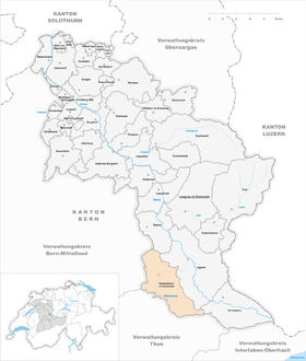
| Location of the municipality | |
  |
|
Röthenbach im Emmental is a municipality in the Emmental administrative district in the canton of Bern in Switzerland .
With the name there is a community of residents and a parish of the Reformed Churches Bern-Jura-Solothurn . A civil community does not exist.
geography
The village of Röthenbach in the Emmental is surrounded by hills around 1000 meters high. It is named after the Röthenbach river , which has its source in the Eggiwil area and flows into the Emme . The municipality extends from the Honegg ( 1546 m above sea level ) to the hamlet of Ryffersegg in the north. Northwest of the Schallenberg Pass ( 1168 m above sea level ) heights of over 1200 meters are also reached.
The community is made up of many hamlets. Along with the village of Röthenbach, Oberei is the largest. All children of the community Röthenbach i. E. are taught in the Röthenbach schoolhouse, which is located in the village.
47 percent of the municipality is forested, which makes Röthenbach one of the most densely wooded municipalities in Switzerland. In addition to forestry, many residents are employed in agriculture. Since arable farming is only possible to a limited extent, it is mainly dairy farming.
The neighboring communities starting from the north in a clockwise direction are Signau , Eggiwil , Schangnau , Eriz , Oberlangenegg , Wachseldorn , Buchholterberg , Linden BE and Bowil .
history

The place was first mentioned in 1148 as Rochembac . At that time there was a monastery in the village, which was closed in 1484. Until the 19th century, the community was considered a stronghold of the cow industry .
In 1905 a parish church was built in the village of Röthenbach, which replaced the Würzbrunnen church. There has been a church in the hamlet of Würzbrunnen for around 1000 years. It was the mother church of the whole Emmental and a well-known place of pilgrimage.
politics
The voting shares of the parties in the 2019 National Council election were: SVP 68.9%, BDP 6.8%, EDU 7.7%, SP 3.3%, EVP 2.7%, GPS 2.4%, FDP 1.9 %, glp 1.8%, 5G goodbye! 1.0%, CVP 0.2%.
Attractions
Röthenbach is known for the Chuderhüsiturm , a wooden observation tower, and the Würzbrunnechiuchli (Würzbrunnenkirche), which is often used for weddings because of its location on a hill in a meadow. The church gained fame through Franz Schnyder's film adaptations of the books by Jeremias Gotthelf .

The village with a church


Web links
- Official website of the municipality of Röthenbach im Emmental
- Anne-Marie Dubler : Röthenbach in the Emmental. In: Historical Lexicon of Switzerland .
Individual evidence
- ↑ Permanent resident population from STAT-TAB of the BfS , municipalities see also regional portraits 2020 on bfs.admin.ch, accessed on May 29, 2020
- ↑ a b Röthenbacher community portrait. In: Röthenbach community. Retrieved August 3, 2013 .
- ^ Anne-Marie Dubler: Röthenbach in the Emmental. In: Historical Lexicon of Switzerland .
- ^ A b c Charles Knapp, Maurice Borel, Victor Attinger, Heinrich Brunner, Société neuchâteloise de geographie (editor): Geographical Lexicon of Switzerland . Volume 4: Plessur - Switzerland . Verlag Gebrüder Attinger, Neuenburg 1906, p. 214, keyword "Rœthenbach" ( scan of the lexicon page ).
- ↑ Würzbrunnen Church (Gotthelf Church). In: Röthenbach community. Retrieved August 3, 2013 .
- ↑ Results of the community Röthenbach in the Emmental. State Chancellery of the Canton of Bern, October 20, 2019, accessed on July 31, 2020 .
Aefligen | Affoltern im Emmental | Alchenstorf | Bätterkinden | Burgdorf | Dürrenroth | Eggiwil | Ersigen | Hasle near Burgdorf | Heimiswil | Hellsau | Hindelbank | Höchstetten | Kernenried | Kirchberg | Koppigen | Krauchthal | Langnau im Emmental | Lauperswil | Lützelflüh | Lyssach | Mötschwil | Oberburg | Röthenbach im Emmental | Rüderswil | Rüdtligen-Alchenflüh | Rüegsau | Rumendingen | Rüti near Lyssach | Schangnau | Signau | Sumiswald | Trachselwald | Trub | Trubschachen | Utzenstorf | Wiler near Utzenstorf | Willadingen | Wynigen | Zielebach
Former parishes: Bärau | Bickigen-Schwanden | Crusher houses | Niederösch | Oberösch | Wil at Koppigen
Canton of Bern | Administrative districts of the canton of Bern | Municipalities of the Canton of Bern