
Mülchi
| Mülchi | ||
|---|---|---|
 |
||
| State : |
|
|
| Canton : |
|
|
| Administrative district : | Bern-Mittelland | |
| Residential municipality : | Fraubrunnen | |
| Postal code : | 3317 | |
| former BFS no. : | 0545 | |
| Coordinates : | 603015 / 216 834 | |
| Height : | 476 m above sea level M. | |
| Area : | 3.8 km² | |
| Residents: | 253 (December 31, 2007) | |
| Population density : | 67 inhabitants per km² | |
| Website: | www.muelchi.ch | |
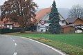
_161.JPG) Mülchi, taken from a balloon on April 16, 2011 |
||
| map | ||
|
||

Until December 31, 2013, Mülchi was a political municipality in the Bern-Mittelland administrative district of the canton of Bern in Switzerland . On January 1, 2014, Mülchi merged with the municipalities of Büren zum Hof , Etzelkofen , Grafenried , Limpach , Schalunen and Zauggenried to form the municipality of Fraubrunnen .
geography
Mülchi lies at 476 m above sea level. M. , 13 kilometers south-southwest of the city of Solothurn (linear distance ). The farm village extends on the southern border of the plane of Limpachtals , on a flat alluvial of Mülchibachs emerging here from the heights of the Rapperswiler plateaus, in the Swiss plateau .
The area of the 3.8 km² municipal area covers a section of the Bernese Mittelland. The northern border runs along the canalized Limpach. From here, the municipality extends southward over the approximately 1 km wide Limpachmoos to the adjacent undulating landscape of the Rapperswil plateau. To the west of the Mülchibach valley cut lies the forest height of Aspi ( 523 m above sea level ), to the east of it the broad ridge of the Schöniberges , on which at 546 m above sea level. M. the highest point of Mülchi is reached. In 1997, 5% of the municipal area was in settlements, 18% in forests and woodlands, 76% in agriculture and a little less than 1% was unproductive land.
Mülchi includes the Im Holz settlement ( 492 m above sea level ) east of the village and some individual farms. Until December 31, 2013 , neighboring communities of Mülchi were Limpach , Büren zum Hof and Etzelkofen in the canton of Bern, and Messen and Unterramsern in the canton of Solothurn .
population
With 253 inhabitants (as of December 31, 2007), Mülchi was one of the small communities in the canton of Bern. 95.9% of the residents speak German, 1.6% speak Italian and 1.2% speak French (as of 2000). The population of Mülchi was 380 in 1850, compared to 282 in 1900. In the course of the 20th century the population decreased continuously by another 25% to 214 people until 1990. Since then, a slight increase in population has been recorded.
politics
The voting shares of the parties on the occasion of the National Council elections in 2011 were: SVP 60.5%, BDP 16.2%, glp 8.8%, SP 3.7%, GPS 2.6%, FDP 2.0%, EVP 1.4 %, EDU 1.4%, CVP 1.1%.

economy
Until the second half of the 20th century, Mülchi was mainly an agricultural village. The water power of the Mülchibach was previously used to operate a mill. Even today, arable farming , fruit growing , dairy farming and cattle breeding play an important role in the income structure of the population. Outside the primary sector there are very few jobs in the village. In the last few decades the village has developed into a residential community. Many employed people are therefore commuters who work mainly in the larger towns in the area as well as in the Bern agglomeration and in the Solothurn area.
traffic
The village is located off the major thoroughfare of a connecting road from Bätterkinden to Lyss . Mülchi is connected to the public transport network through a PostBus course , which runs from Bätterkinden to Messen .
history
The place was first mentioned in a document in 1272 under the name Mulnheim . Later the names Mulheim (1354), Mulchein (1531), Mülchy (1570) and Mülchi (1637) appeared. The original meaning of the place name is Siedlung bei der Mühle , derived from the Old High German word mulin (mill).
Mülchi has been under the sovereignty of the Counts of Kyburg since the Middle Ages . In the 13th century, the Cistercian monastery Fraubrunnen acquired the tithe over Mülchi. In 1406 the village came under the rule of Bern and was assigned to the Zollikofen district court . On September 1, 1773, numerous houses fell victim to a fire. After the collapse of the Ancien Régime (1798), Mülchi belonged to the Zollikofen district during the Helvetic Republic and from 1803 to the Oberamt Fraubrunnen, which received the status of an official district with the new cantonal constitution of 1831.
As early as the 18th century, great efforts were made to counteract the swamping of the Limpach valley. New cultivated land, however, was only during the cross-cantonal land improvement gained in the years 1939-1951.
Rudolf Minger , who later became Federal Councilor, was born in Mülchi in 1881. After a year in Welschland, he worked on his parents' farm until 1907, where he continued his autodidactic training during a long illness.
Attractions
With its numerous characteristic farmhouses from the 18th and 19th centuries, Mülchi has a site of national importance that is worth protecting. There is a typical Tauner settlement on Moosgasse west of the village . The former mill dates from 1848. Mülchi does not have its own church, it belongs to the Solothurn parish of Messen.
Weather
Since November 18, 2015, the Mülchi weather station has been delivering data to the Internet and to numerous weather services such as B. Meteonews, Wetter.com, Weather Underground. Since then, Mülchi has been shown several times on SRF Meteo.
photos

Dairy in the center of Mülchi
Entrance to the village of Mülchi

Mülchi as seen from the Buechibärg
_150.JPG)
_136.JPG)

Web links
- Official website of the Mülchi municipality
- Anne-Marie Dubler : Mülchi. In: Historical Lexicon of Switzerland .
- Mülchi weather station
Individual evidence
- ↑ http://www.wahlarchiv.sites.be.ch/wahlen2011/target/NAWAInternetAction.do@method=read&sprache=d&typ=21&gem=545.html accessed on July 11, 2012
- ^ Peter Stettler: Rudolf Minger. In: Historical Lexicon of Switzerland .
- ↑ Mülchi weather station. Retrieved July 22, 2017 .
Allmendingen | Arni | Bäriswil | Belp | Bern | Biglen | Bolligen | Bowil | Bremgarten near Bern | Brenzikofen | Clavaleyres | Deisswil near Münchenbuchsee | Diemerswil | Ferenbalm | Fraubrunnen | Frauenkappelen | Open-leaved | Gerzensee | Grosshöchstetten | Guggisberg | Gurbrü | Membranous | Herbigen | Iffwil | Ittigen | Jaberg | Jegenstorf | Kaufdorf | Sweep | Gravel | Kirchdorf | Kirchlindach | Köniz | Konolfingen | Kriechenwil | Landiswil | Laupen | Linden | Mattstetten | Meikirch | Mirchel | Moosseedorf | Mühleberg | Münchenbuchsee | Münchenwiler | Münsingen | Muri near Bern | Neuenegg | Niederhünigen | Niedermuhlern | Oberbalm | Oberdiessbach | Oberhünigen | Oberthal | Oppligen | Ostermundigen | Riggisberg | Rubigen | Rüeggisberg | Rümligen | Rüschegg | Schwarzenburg | Stettlen | Thurnen | Toff | Urtenen-Schönbühl | Vechigen | Forest | Walk rings | Wichtrach | Wiggiswil | Wileroltigen | Wohlen near Bern | Worb | Zziwil | Zollikofen | Zuzwil
Former communities: Aeschlen bei Oberdiessbach | Albligen | Ausserbirrmoos | Ball moss | Perch wall | Belpberg | Bleiken near Oberdiessbach | Bremgarten City Court | Bümpliz | Büren to the yard | Englisberg | Etzelkofen | Gelterfingen | Golats | Grafenried | Gysenstein | Hoods | Innerbirrmoos | Church gymnastics | Limpach | Lohnstorf | Mädersforst | Measure barns | Mühledorf | Mill urns | Mülchi | Münchringen | Niederwichtrach | Noflen | Oberscheunen | Oberwichtrach | Otterbach near Oberdiessbach | Rüti near Riggisberg | Shells | Barns | Schlosswil | Schönthal | Stalden in the Emmental | Tägertschi | Trimstone | Electors | Zauggenried | Zimmerwald
Canton of Bern | Administrative districts of the canton of Bern | Municipalities of the Canton of Bern