
Bern-Mittelland administrative district
| Bern-Mittelland administrative district | |
|---|---|
| Basic data | |
| Country: |
|
| Canton : |
|
| Main town : | Ostermundigen |
| FSO number : | 0246 |
| Area : | 943.46 km² |
| Height range : | 449–2188 m above sea level M. |
| Residents: | 414,658 (December 31, 2018) |
| Population density : | 440 inhabitants per km² |
| map | |
 |
|
Coordinates: 46 ° 57 ' N , 7 ° 24' E ; CH1903: 596671 / 200 392
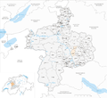
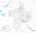
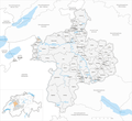
The Bern-Mittelland in the canton of Bern was founded on January 1 of 2010. It belongs to the administrative region of Bern-Mittelland (of which it is the only district) and comprises 77 municipalities in an area of 943.46 km² with a total of 414,658 inhabitants:
Status of the municipality list: January 1, 2020, population status: December 31, 2018 It is the same as of the regional conference Bern-Mittelland .
Communities
| coat of arms | Name of the parish | Population (December 31, 2018) |
Area in km² | Inhabitants per km² |
|---|---|---|---|---|
|
|
Allmendingen | 590 | 3.81 | 155 |
|
|
Arni (BE) | 928 | 10.43 | 89 |
|
|
Bäriswil | 1062 | 2.73 | 389 |
|
|
Belp | 11,510 | 23.26 | 495 |
|
|
Bern | 133,883 | 51.62 | 2594 |
|
|
Biglen | 1815 | 3.59 | 506 |
|
|
Bolligen | 6264 | 16.57 | 378 |
|
|
Bowil | 1373 | 14.68 | 94 |
|
|
Bremgarten near Bern | 4387 | 1.90 | 2309 |
|
|
Brenzikofen | 488 | 2.19 | 223 |
|
|
Clavaleyres | 46 | 1.00 | 46 |
|
|
Deisswil near Münchenbuchsee | 86 | 2.16 | 40 |
|
|
Diemerswil | 206 | 2.86 | 72 |
|
|
Ferenbalm | 1260 | 9.13 | 138 |
|
|
Fraubrunnen | 5113 | 31.91 | 160 |
|
|
Frauenkappelen | 1240 | 9.29 | 133 |
|
|
Open greases | 466 | 2.96 | 157 |
|
|
Gerzensee | 1215 | 7.81 | 156 |
|
|
Grosshöchstetten | 4166 | 6.93 | 601 |
|
|
Guggisberg | 1508 | 54.91 | 27 |
|
|
Gurbrü | 261 | 1.86 | 140 |
|
|
Skinned | 250 | 3.07 | 81 |
|
|
Herbigen | 603 | 2.76 | 218 |
|
|
Iffwil | 443 | 5.06 | 88 |
|
|
Ittigen | 11,351 | 4.20 | 2703 |
|
|
Jaberg | 278 | 1.31 | 212 |
|
|
Jegenstorf | 5746 | 13.49 | 426 |
|
|
Kaufdorf | 1089 | 2.06 | 529 |
|
|
Sweeping | 4305 | 4.44 | 970 |
|
|
Pebbles | 1001 | 4.69 | 213 |
|
|
Kirchdorf (BE) | 1843 | 14.62 | 126 |
|
|
Kirchlindach | 3160 | 11.96 | 264 |
|
|
Koeniz | 41,784 | 51.01 | 819 |
|
|
Konolfingen | 5283 | 12.77 | 414 |
|
|
Kriechenwil | 427 | 4.77 | 90 |
|
|
Landiswil | 625 | 10.26 | 61 |
|
|
Laupen | 3136 | 4.14 | 757 |
|
|
Linden trees | 1298 | 13.23 | 98 |
|
|
Mattstetten | 561 | 3.79 | 148 |
|
|
Meikirch | 2461 | 10.23 | 241 |
|
|
Mirchel | 624 | 2.34 | 267 |
|
|
Moosseedorf | 4111 | 6.38 | 644 |
|
|
Mühleberg | 2986 | 26.26 | 114 |
|
|
Münchenbuchsee | 10'213 | 8.81 | 1159 |
|
|
Münchenwiler | 522 | 2.48 | 210 |
|
|
Münsingen | 12,724 | 15.77 | 807 |
|
|
Muri near Bern | 13,054 | 7.63 | 1711 |
|
|
Neuenegg | 5541 | 21.83 | 254 |
|
|
Prostrate | 644 | 5.42 | 119 |
|
|
Niedermuhlern | 501 | 7.26 | 69 |
|
|
Oberbalm | 853 | 12.39 | 69 |
|
|
Oberdiessbach | 3527 | 16.47 | 214 |
|
|
Oberhünigen | 313 | 6.02 | 52 |
|
|
Oberthal | 727 | 10.54 | 69 |
|
|
Oppligen | 650 | 3.40 | 191 |
|
|
Ostermundigen | 17,751 | 5.96 | 2978 |
|
|
Riggisberg | 2554 | 29.84 | 86 |
|
|
Rubigen | 2929 | 6.92 | 423 |
|
|
Rüeggisberg | 1791 | 35.81 | 50 |
|
|
Rumbly | 438 | 4.66 | 94 |
|
|
Rüschegg | 1662 | 57.30 | 29 |
|
|
Schwarzenburg | 6831 | 44.80 | 152 |
|
|
Stettlen | 3116 | 3.50 | 890 |
|
|
Toff | 2515 | 4.88 | 515 |
|
|
Thurnen | 1922 | 5.95 | 323 |
|
|
Urtenen-Schönbühl | 6271 | 7.19 | 872 |
|
|
Vechigen | 5298 | 24.82 | 213 |
|
|
Forest (BE) | 1177 | 13.30 | 88 |
|
|
Walk wrestling | 1767 | 17.21 | 103 |
|
|
Wichtrach | 4293 | 11.60 | 370 |
|
|
Wiggiswil | 103 | 1.44 | 72 |
|
|
Wileroltigen | 360 | 4.15 | 87 |
|
|
Wohlen near Bern | 9282 | 36.32 | 256 |
|
|
Worb | 11'316 | 21.08 | 537 |
|
|
Zziwil | 1595 | 5.41 | 295 |
|
|
Zollikofen | 10,306 | 5.39 | 1912 |
|
|
Zuzwil (BE) | 578 | 3.47 | 167 |
| Total (77) | 414,658 | 943.46 | 440 | |
The municipalities come from the previous administrative districts
- Aarberg (Meikirch),
- Bern (all),
- Burgdorf (Bäriswil),
- Fraubrunnen ,
- Konolfingen (all),
- Laupen (all),
- Schwarzenburg (all) and
- Juicy .
Changes in the community since 2010

Municipalities until 2010

Municipalities until 2011
Municipalities until 2012

Municipalities until 2013

Municipalities until 2016
Municipalities until 2017
Municipalities by 2018

Municipalities by 2019


- Mergers
- 2011: Albligen and Wahlern → Schwarzenburg
- 2014: Büren zum Hof , Etzelkofen , Fraubrunnen , Grafenried , Limpach , Mülchi , Schalunen and Zauggenried → Fraubrunnen
- 2014: Jegenstorf , Münchringen and Scheunen → Jegenstorf
- 2014: Bleiken near Oberdiessbach and Oberdiessbach → Oberdiessbach
- 2017: Münsingen and Tägertschi → Münsingen
- 2018: Gelterfingen , Kirchdorf , Mühledorf and Noflen → Kirchdorf
- 2018: Grosshöchstetten and Schlosswil → Grosshöchstetten
- 2019: Golaten and Kallnach ( Seeland administrative district ) → Kallnach
- 2020: Kirchenthurnen , Lohnstorf and Mühlethurnen → Thurnen
Web links
Individual evidence
- ↑ Permanent resident population from STAT-TAB of the BfS , municipalities see also regional portraits 2020 on bfs.admin.ch, accessed on May 29, 2020
- ↑ a b Federal Statistical Office Generalized Limits 2020.