
District of Bern
| District of Bern | |
|---|---|
 |
|
| Basic data | |
| Country: |
|
| Canton : |
|
| Main town : | Bern |
| Area : | 233.27 km² |
| Residents: | 239,382 (December 31, 2008) |
| Population density : | 1026 inhabitants per km² |
| map | |
 |
|

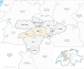
The district of Bern was an administrative unit of the Canton of Bern , which has only existed as an electoral district since 2009. The district with the capital Bern comprised 13 communities on 233.27 km². It is roughly congruent with the agglomeration of Bern. On December 31, 2008, the district of Bern had 239,382 inhabitants.
Communities
| Name of the parish | Population (December 31, 2008) |
Area in km² |
Inhabitants per km² |
|---|---|---|---|
| Bern | 122,925 | 51.62 | 2381 |
| Bolligen | 6077 | 16.57 | 367 |
| Bremgarten near Bern | 3974 | 1.90 | 2092 |
| Ittigen | 10,737 | 4.20 | 2556 |
| Kirchlindach | 2757 | 11.96 | 231 |
| Koeniz | 37,974 | 51.01 | 744 |
| Muri near Bern | 12,752 | 7.63 | 1671 |
| Oberbalm | 870 | 12.39 | 70 |
| Ostermundigen | 15'031 | 5.96 | 2522 |
| Stettlen | 2869 | 3.50 | 820 |
| Vechigen | 4650 | 24.82 | 187 |
| Wohlen near Bern | 8986 | 36.32 | 247 |
| Zollikofen | 9780 | 5.39 | 1814 |
| Total (13) | 239,382 | 233.27 | 1026 |
Changes in the community
Municipalities until 1918
Municipalities until 1982

Municipalities until 2009


- 1880: Merger of Bremgarten City Court and Kirchlindach → Kirchlindach
- 1919: Merger of Bern and Bümpliz → Bern
- 1983: Split from Bolligen → Ittigen and Ostermundigen
Web links
Individual evidence
Aarberg | Aarwangen | Bern | Biel | Büren | Burgdorf | Courtelary | Erlach | Fraubrunnen | Frutigen | Interlaken | Konolfingen | Laupen | Moutier | La Neuveville | Nidau | Lower Simmental | Oberhasli | Obersimmental | Saanen | Schwarzenburg | Juicy | Signau | Tuna | Trachselwald | Cheeks
Canton of Bern | Districts of Switzerland | Municipalities of the Canton of Bern