
Aarwangen district
| Aarwangen district | |
|---|---|
-coat_of_arms.svg) |
|
| Basic data | |
| Country: |
|
| Canton : |
|
| Main town : | Aarwangen |
| Area : | 154.02 km² |
| Residents: | 41,839 (December 31, 2008) |
| Population density : | 272 inhabitants per km² |
| map | |
 |
|
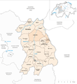
The Aarwangen district is an administrative unit of the Canton of Bern . It comprises 24 communities and had 41,839 inhabitants (as of December 31, 2008) on 154.02 km².
Communities
| Name of the parish | Population (December 31, 2008) |
Area in km² |
Inhabitants per km² |
|---|---|---|---|
| Aarwangen | 4250 | 9.90 | 429 |
| Exit | 463 | 4.62 | 100 |
| Bannwil | 659 | 4.78 | 138 |
| Bleienbach | 665 | 5.69 | 117 |
| Busswil near Melchnau | 195 | 2.86 | 68 |
| Gondiswil | 725 | 9.40 | 77 |
| Kleindietwil | 486 | 2.70 | 180 |
| Langenthal | 14,777 | 14.40 | 1026 |
| Leimiswil | 412 | 4.60 | 90 |
| Lotzwil | 2431 | 6.22 | 391 |
| Madiswil | 2150 | 15.80 | 136 |
| Melchnau | 1531 | 10.27 | 149 |
| Top stake | 388 | 3.91 | 99 |
| Oeschenbach | 263 | 3.92 | 67 |
| Reisiswil | 184 | 2.01 | 92 |
| Roggwil (BE) | 3786 | 7.84 | 483 |
| Rohrbach | 1391 | 4.08 | 341 |
| Rohrbachgraben | 423 | 6.46 | 65 |
| Rütschelen | 559 | 3.98 | 140 |
| Black houses | 473 | 3.79 | 125 |
| Thunstetten | 2970 | 9.66 | 307 |
| Undercutting wood | 167 | 2.88 | 58 |
| Ursenbach | 931 | 9.17 | 102 |
| Wynau | 1560 | 5.07 | 308 |
| Total (24) | 41,839 | 154.02 | 272 |
Changes in the community

Municipalities until 1897

Municipalities until 2006
Municipalities until 2009


- 1898: Merger of Langenthal and Schoren → Langenthal
- 2006: Merger of Madiswil and Gutenburg → Madiswil
- 2010: Merger of Langenthal and Untersteckholz → Langenthal
- 2010: District change of all 24 municipalities from the Aarwangen district → Oberaargau administrative district
See also
literature
Individual evidence
Aarberg | Aarwangen | Bern | Biel | Büren | Burgdorf | Courtelary | Erlach | Fraubrunnen | Frutigen | Interlaken | Konolfingen | Laupen | Moutier | La Neuveville | Nidau | Lower Simmental | Oberhasli | Obersimmental | Saanen | Schwarzenburg | Juicy | Signau | Tuna | Trachselwald | Cheeks
Canton of Bern | Districts of Switzerland | Municipalities of the Canton of Bern

Four parishes: Bolligen | Vechigen | Stettlen | Muri
Regional courts: Seftigen | Sternenberg | Konolfingen | Zollikofen
Offices: Thun | Zofingen | Aarau | Lenzburg | Brugg | Burgdorf | Büren | Unterseen | Wiedlisbach | Obersimmental | Lower Simmental | Frutigen | Oberhofen | Aigle | Hasli | Trachselwald | Bipp | Aarwangen | Cheeks | Landshut | Lenzburg (Office) | Schenkenberg | Aarberg | Nidau | Erlach | Laupen | Oltigen | Signau | Biberstein | Aarburg | Saanen | Brandis | Interlaken | Königsfelden | Thorberg | Fraubrunnen | Zofingen (pen) | Frienisberg | St. Johannsen | Gottstatt | Buchsee | Sumiswald | Roche (Saline) | Köniz | Kasteln | Hettiswil
Offices in Vaud: Avenches | Moudon | Yverdon | Lausanne | Morges | Nyon | Vevey | Romainmôtier | Oron | Payerne | Bonmont | Aubonne
Common lords with Freiburg: Schwarzenburg | Murten | Grandson | Echallens
Common federal dominions: Baden | Thurgau | Free offices | Rhine Valley | Sargans | Locarno | Lugano | Mendrisio | Valle Maggia
Offices and services in the city of Bern: Bauamt | Salt Directorate | Mushafen | Pen | Corn Office | Big hospital | Inselspital