
Frutigen district
| Frutigen district | |
|---|---|
 |
|
| Basic data | |
| Country: |
|
| Canton : |
|
| Main town : | Frutigen |
| Area : | 489.07 km² |
| Residents: | 18,643 (December 31, 2008) |
| Population density : | 38 inhabitants per km² |
| map | |
 |
|
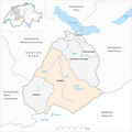
The district of Frutigen was an administrative unit of the canton of Bern until December 31, 2009 . The administrative district with the main town of Frutigen comprised seven communities on 489.07 km²:
The administrative district of Frutigen was essentially identical to the historical region of Frutigland .
Communities
| Name of the parish | Population (December 31, 2008) |
Area in km² | Inhabitants per km² |
|---|---|---|---|
| Adelboden | 3615 | 87.61 | 41 |
| Aeschi near Spiez | 1981 | 30.99 | 64 |
| Frutigen | 6682 | 72.28 | 92 |
| Kandergrund | 811 | 32.09 | 25th |
| Kandersteg | 1203 | 134.33 | 9 |
| Krattigen | 953 | 6.00 | 159 |
| Reichenbach in the Kandertal | 3398 | 125.77 | 27 |
| Total (7) | 18,643 | 489.07 | 38 |
Changes in the community
Parishes until 1849

Municipalities until 1908

Municipalities until 1956

Municipalities until 2009


- 1850: Split from Frutigen → Kandergrund
- 1909: Split from Kandergrund → Kandersteg
- 1957: Change of name from Reichenbach near Frutigen → Reichenbach im Kandertal
- 2010: District change of all 7 municipalities from the Frutigen district → Frutigen-Niedersimmental administrative district
Web links
- Anne-Marie Dubler : Frutigen (rule, administrative district). In: Historical Lexicon of Switzerland .
Individual evidence
Aarberg | Aarwangen | Bern | Biel | Büren | Burgdorf | Courtelary | Erlach | Fraubrunnen | Frutigen | Interlaken | Konolfingen | Laupen | Moutier | La Neuveville | Nidau | Lower Simmental | Oberhasli | Obersimmental | Saanen | Schwarzenburg | Juicy | Signau | Tuna | Trachselwald | Cheeks
Canton of Bern | Districts of Switzerland | Municipalities of the Canton of Bern

Four parishes: Bolligen | Vechigen | Stettlen | Muri
Regional courts: Seftigen | Sternenberg | Konolfingen | Zollikofen
Offices: Thun | Zofingen | Aarau | Lenzburg | Brugg | Burgdorf | Büren | Unterseen | Wiedlisbach | Obersimmental | Lower Simmental | Frutigen | Oberhofen | Aigle | Hasli | Trachselwald | Bipp | Aarwangen | Cheeks | Landshut | Lenzburg (Office) | Schenkenberg | Aarberg | Nidau | Erlach | Laupen | Oltigen | Signau | Biberstein | Aarburg | Saanen | Brandis | Interlaken | Königsfelden | Thorberg | Fraubrunnen | Zofingen (pen) | Frienisberg | St. Johannsen | Gottstatt | Buchsee | Sumiswald | Roche (Saline) | Köniz | Kasteln | Hettiswil
Offices in Vaud: Avenches | Moudon | Yverdon | Lausanne | Morges | Nyon | Vevey | Romainmôtier | Oron | Payerne | Bonmont | Aubonne
Common lords with Freiburg: Schwarzenburg | Murten | Grandson | Echallens
Common federal dominions: Baden | Thurgau | Free offices | Rhine Valley | Sargans | Locarno | Lugano | Mendrisio | Valle Maggia
Offices and services in the city of Bern: Bauamt | Salt Directorate | Mushafen | Pen | Corn Office | Big hospital | Inselspital