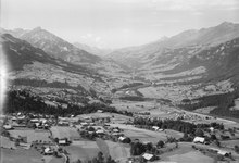
Reichenbach in the Kandertal
| Reichenbach in the Kandertal | |
|---|---|
| State : |
|
| Canton : |
|
| Administrative district : | Frutigen-Niedersimmental |
| BFS no. : | 0567 |
| Postal code : | 3713 |
| UN / LOCODE : | CH RNB |
| Coordinates : | 618 744 / 162 853 |
| Height : | 700 m above sea level M. |
| Height range : | 689–3619 m above sea level M. |
| Area : | 125.76 km² |
| Residents: | 3608 (December 31, 2018) |
| Population density : | 27 inhabitants per km² |
| Website: | www.reichenbach.ch |
|
Reichenbach in the Kandertal |
|
| Location of the municipality | |
Reichenbach im Kandertal (officially called Reichenbach bei Frutigen until 1957 ) is a political municipality in the Frutigen-Niedersimmental administrative district in the canton of Bern in Switzerland .
geography
The structure of the municipality of Reichenbach is complex. The community is divided into the eight farmers (sub-communities) Reichenbach, Faltschen , Scharnachtal , Kiental , Kien-Aris , Reudlen , Wengi and Schwandi . These "farmers" are autonomous and administered by their own commissions. Politically, they belong to the community of Reichenbach.
The municipality stretches from the summit of the Niesen in the northwest to the summit of the Blüemlisalp at 3,664 meters above sea level. In between is the lowest point at 690 meters above sea level. Cattle and sheep are summered on around 120 alpine farms. The natural and cultural landscape of the Kiental is popular with hikers.
history
The Alps were probably already inhabited in Celtic times, as evidenced by the Celtic naming of the river Kander , which means "the white one", and the brook Suld, which means "ditch". The name Reichenbach comes from the Old High German rihhi ("rich, powerful") and the word bah ("Bach").
The community used to be part of the Mülenen - Aeschi dominion in Frutigland. Above Kien there are traces of a former castle ( Mülenen castle ruins ), from which the family of the Barons von Kien , the first known lords of Mülinen, probably began. Around 1400, the feudal lord Anton von Turm sold the Mülenen-Aeschi and Frutigen lords for 6200 Florentine guilders to the Bern estate . Reichenbach has been an independent parish since 1528 . In the 16th century, through traffic to the baths in Leukerbad ( Valais ) increased in importance. The first inns date from this time, such as B. the "Bären" (built in 1542) in Reichenbach.
Poverty forced many people to emigrate in the 17th and 18th centuries . It was not until the development of the traffic routes that the Frutig Valley experienced an economic boom in the 19th century. There has been a postal service from Reichenbach to Kiental since 1899. In 1930 carriage traffic was replaced by the post bus and extended to the Griesalp. With a 28 percent gradient, the Kiental – Griesalp route is the steepest mountain post route in Europe. With the opening of the Lötschberg line through the Lötschberg tunnel in 1913, the Kandertal was connected to the “wide world”.
During the Second World War , the Reichenbach military airfield was built as part of the Reduit .
On August 22, 2005 the entire village was flooded by the Kiene overflowing its banks. Serious property damage occurred. The part of the village of Kien, which was under water for several days, was particularly hard hit. A total of 300 people had to be evacuated and around 100 houses were affected by the masses of water.
Since 1910, the Niesenbahn , a funicular , has been used to travel up the Niesen (2362 meters) from the Mülenen valley station .
politics
The voting shares of the parties at the 2015 National Council election were: SVP 55.8%, BDP 9.7%, SP 7.3%, FDP 6.4%, EDU 6.3%, glp 5.7%, GPS 3.6 %, EVP 2.0%, CVP 0.6%.
Attractions
Web links
- Official website of the community of Reichenbach im Kandertal
- Anne-Marie Dubler : Reichenbach in the Kandertal. In: Historical Lexicon of Switzerland .
Individual evidence
- ↑ Permanent resident population from STAT-TAB of the BfS , municipalities see also regional portraits 2020 on bfs.admin.ch, accessed on May 29, 2020
- ^ Results of the Reichenbach community. State Chancellery of the Canton of Bern, October 18, 2015, accessed on October 30, 2016 .


