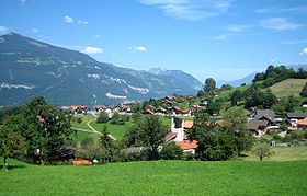
Krattigen
| Krattigen | |
|---|---|
| State : |
|
| Canton : |
|
| Administrative district : | Frutigen-Niedersimmental |
| BFS no. : | 0566 |
| Postal code : | 3704 |
| Coordinates : | 621 284 / 166567 |
| Height : | 712 m above sea level M. |
| Height range : | 558–1587 m above sea level M. |
| Area : | 6.00 km² |
| Residents: | 1132 (December 31, 2018) |
| Population density : | 165 inhabitants per km² |
| Website: | www.krattigen.ch |
|
Krattigen |
|
| Location of the municipality | |
Krattigen is a municipality in the Frutigen-Niedersimmental administrative district in the canton of Bern in Switzerland .
In addition to the residents' community, there is also a civic community under the name Krattigen . The Evangelical Reformed parish is run together with Aeschi near Spiez , but both have their own church.
The municipality of Krattigen as well as the hamlets of Stuhlegg and Örtlimatt and many individual farms belong to the municipality .
geography
The community is located on a hill above Lake Thun . Krattigen is 750 m above sea level. M. on a gypsum moraine. In the southeast the community rises to the top of the Greberegg up to an altitude of 1595 meters. The neighboring communities starting from the east and clockwise are Leissigen , Aeschi bei Spiez and Spiez as well as Sigriswil and Beatenberg on the other bank of Lake Thun .
history
The village of Krattigen was first mentioned in a document on January 4, 1297 and was then the property of the nobles von Eschenbach, but was actually still under the control of the Habsburgs. In 1483 the rule of Krattigen passed entirely to the von Scharnachtal, who were citizens of Bern. In 1513 all of the Twing, Bann and the manorial rights to Krattigen were transferred to the city of Bern for the purchase price of 1400 pounds, thus forming the Kastlanei Frutigen. In the Krattiger freedom letter of May 6, 1476, the Krattigen court was granted a land right which remained in force when Bern became the direct ruler. This land right lasted until the French Revolution and was only formally declared expired by the Grand Council resolution of December 2, 1840.
politics
The president of the municipality and council is Christian Kummer (as of 2014).
The voting shares of the parties at the 2015 National Council election were: SVP 33.8%, BDP 24.6%, SP 11.5%, EPP 6.7%, glp 5.4%, GPS 4.9%, FDP 4.8 %, EDU 4.6%, CVP 1.6%.
economy
In addition to the church, there are six post bus stops in Krattigen, a bakery with a well-stocked range of groceries and fresh products, and two hotels.
Although the Spiez - Interlaken railway runs along the lake, there is no train station.
Personalities
- Walter J. Hollenweger (1927–2016), Protestant Reformed theologian, lived in Krattigen until his death
- Ernst Ramseier (* 1936), painter, graphic artist
- Werner Luginbühl (* 1958), Bernese Council of States
- Gian Simmen (* 1977), Olympic champion in the halfpipe '98
See also
literature
- Horst Gradinger: Chronicle of the tribe KRATTI (N) GER / GRADINGER , in the context of the historical territorial events with genealogical tables and numerous directories, Krefeld 2980
- Daniel Miescher (ed.): The artillery works Krattigen A1952
Web links
- Official website of the municipality of Krattigen
- Anne-Marie Dubler : Krattigen. In: Historical Lexicon of Switzerland .
Individual evidence
- ↑ Permanent resident population from STAT-TAB of the BfS , municipalities see also regional portraits 2020 on bfs.admin.ch, accessed on May 29, 2020
- ^ Results of the Krattigen community. State Chancellery of the Canton of Bern, October 18, 2015, accessed on October 30, 2016 .
- ^ Artillery Fort Spiez Krattigen. In: afosk.ch. Retrieved November 13, 2013 .


