
Wiedlisbach
| Wiedlisbach | |
|---|---|
 |
|
| State : |
|
| Canton : |
|
| Administrative district : | Oberaargau |
| BFS no. : | 0995 |
| Postal code : | 4537 |
| UN / LOCODE : | CH WBA |
| Coordinates : | 615 623 / 233 252 |
| Height : | 465 m above sea level M. |
| Height range : | 415–604 m above sea level M. |
| Area : | 7.50 km² |
| Residents: | 2377 (December 31, 2018) |
| Population density : | 317 inhabitants per km² |
| Website: | www.wiedlisbach.ch |
 Wiedlisbach with the residential tower |
|
| Location of the municipality | |
  |
|
Wiedlisbach is a municipality in the Oberaargau administrative district in the canton of Bern in Switzerland .
The community consists of the town of the same name and is located in the Oberaargau region at the southern foot of the Jura , the northeastern part of the canton of Bern . Wiedlisbach is characterized by its well-preserved medieval town center, for which the community has been awarded various prizes (1974 Henri-Louis-Wakker Prize for exemplary local care, 1975 award from the Council of Europe ).
Adjacent communities are Attiswil in the west, Rumisberg in the north, Oberbipp in the east and Wangen an der Aare in the south.
history

Numerous Bronze Age, Roman and early medieval finds are known in the area around Wiedlisbach. The place Wiedlisbach (probably derived from Middle High German wîde « Weide , Weidenrute ») was first mentioned as a town in 1275. The founding and granting of town charter - probably due to its strategically important location on the north − south trade routes - should be dated around 1240. The town is located on the road from Basel via Solothurn to Biel and includes a parallel side street in addition to the main street. It was surrounded by a curtain wall. In the north-west corner is the town tower (seat of the Frohburgischen Vogts), near the north-east corner the chapel. The town was part of the parish of Oberbipp. Customs and markets have been documented since the 14th century.
After the place founded by the Counts of Frohburg changed hands several times as a pledge, in 1463 it finally came to the then state and current canton of Bern. In 1487 a hospital was founded. In the 16th century, around 250 people lived in the town, in the 18th century around 500. Wiedlisbach celebrated its 750th anniversary with a three-day festival in June 2005.
Attractions
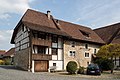
- Kornhaus / Museum - Former Kornhaus, mostly from 1693. Various uses, local museum since 1955.
- Restaurant Krone - Mentioned in a document as the Gasthaus zum Rappen in the 16th century, burned down completely in 1800, rebuilt in 1823 as Gasthof Krone.
- Gasthof Schlüssel - a building that is valuable in terms of architecture and local history. Site of the conspiracy of the Counts of Kyburg against the city of Solothurn (1382). Hans Roth from Rumisberg saves the city. Accommodation of Emperor Joseph II.
- Tower / city wall - residential tower built in the 13th century. Served as a granary from the 16th to the 19th century, today it is used as living space again. The landmark of Wiedlisbach.
- Old Mill
traffic
Wiedlisbach is well developed in terms of traffic. Since 1918 there has been a direct rail connection to Solothurn and via Niederbipp to Langenthal (former Solothurn-Niederbipp-Bahn ). In December 2012 the new Niederbipp – Oensingen line was (re) opened, which means that there is now a direct connection to the SBB long-distance network. Wangen an der Aare and the mountain communities Rumisberg and Farnern are accessible via a bus route. The connection to the A1 motorway ( Bern - Zurich ) is a few minutes away from the village.
photos

Community and canton coats of arms

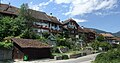
St. Katharinen Chapel in Hinterstädtli

Hinterstädtli

House in Hinterstädtli
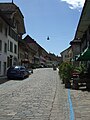
Städtli

Old Mill
South view of the town

Wiedlisbach station with the new "Bipperlisi"

Residential tower and Kornhaus museum
In the Hinterstädtli


Personalities
- Christian Amport (around 1540–1590), Protestant clergyman and university professor at the high school in Bern
literature
- Adriano Boschetti-Maradi, Martin Portmann: The little town of Wiedlisbach. Report on the archaeological investigations up to the year 2000 . Rub Media, Bern 2004, ISBN 3-907663-01-2 , ( series of publications by the Education Department of the Canton of Bern ).
Web links
- Official website of the Wiedlisbach community
- Anne-Marie Dubler : Wiedlisbach. In: Historical Lexicon of Switzerland .
- Burgenwelt: Wiedlisbach city fortifications
Individual evidence
- ↑ Permanent resident population from STAT-TAB of the BfS , municipalities see also regional portraits 2020 on bfs.admin.ch, accessed on May 29, 2020
- ↑ Alfred Helfenstein: The Namengut Pilate territory. Keller, Luzern 1982, ISBN 3-85766-004-X , p. 39.
Aarwangen | Attiswil | Exit | Bannwil | Berken | Bettenhausen | Bleienbach | Busswil near Melchnau | Eriswil | Farners | Gondiswil | Dig | Heimenhausen | Herzogenbuchsee | Huttwil | Inkwil | Langenthal | Lotzwil | Madiswil | Melchnau | Niederbipp | Niederönz | Oberbipp | Top stake | Ochlenberg | Oeschenbach | Reisiswil | Roggwil | Rohrbach | Rohrbachgraben | Rumisberg | Rütschelen | Black Houses | Seeberg | Foolish | Thunstetten | Ursenbach | Walliswil near Niederbipp | Walliswil near Wangen | Walterswil | Wangen an der Aare | Wangenried | Wiedlisbach | Wynau | Wyssachen
Former municipalities: Bollodingen | Gutenburg | Hermiswil | Kleindietwil | Leimiswil | Oberönz | Röthenbach near Herzogenbuchsee | Shear | Undercut wood | Wanzwil | Wolfisberg
Canton of Bern | Administrative districts of the canton of Bern | Municipalities of the Canton of Bern

Four parishes: Bolligen | Vechigen | Stettlen | Muri
Regional courts: Seftigen | Sternenberg | Konolfingen | Zollikofen
Offices: Thun | Zofingen | Aarau | Lenzburg | Brugg | Burgdorf | Büren | Unterseen | Wiedlisbach | Obersimmental | Lower Simmental | Frutigen | Oberhofen | Aigle | Hasli | Trachselwald | Bipp | Aarwangen | Cheeks | Landshut | Lenzburg (Office) | Schenkenberg | Aarberg | Nidau | Erlach | Laupen | Oltigen | Signau | Biberstein | Aarburg | Saanen | Brandis | Interlaken | Königsfelden | Thorberg | Fraubrunnen | Zofingen (pen) | Frienisberg | St. Johannsen | Gottstatt | Buchsee | Sumiswald | Roche (Saline) | Köniz | Kasteln | Hettiswil
Offices in Vaud: Avenches | Moudon | Yverdon | Lausanne | Morges | Nyon | Vevey | Romainmôtier | Oron | Payerne | Bonmont | Aubonne
Common lords with Freiburg: Schwarzenburg | Murten | Grandson | Echallens
Common federal dominions: Baden | Thurgau | Free offices | Rhine Valley | Sargans | Locarno | Lugano | Mendrisio | Valle Maggia
Offices and services in the city of Bern: Bauamt | Salt Directorate | Mushafen | Pen | Corn Office | Big hospital | Inselspital