
Walliswil near Wangen
| Walliswil near Wangen | |
|---|---|
 |
|
| State : |
|
| Canton : |
|
| Administrative district : | Oberaargau |
| BFS no. : | 0991 |
| Postal code : | 3377 |
| Coordinates : | 618 658 / 231192 |
| Height : | 456 m above sea level M. |
| Height range : | 417–494 m above sea level M. |
| Area : | 3.07 km² |
| Residents: | 608 (December 31, 2018) |
| Population density : | 198 inhabitants per km² |
| Website: | www.walliswil.ch |
_077.JPG) The two Walliswil, photographed from a balloon on April 16, 2011, Walliswil near Wangen on the right of the Aare |
|
| Location of the municipality | |
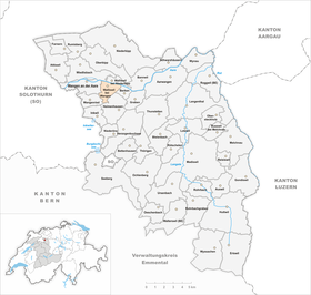  |
|
Walliswil bei Wangen is a municipality in the Oberaargau administrative district in the canton of Bern in Switzerland .
geography
Walliswil bei Wangen lies at 456 m above sea level. M. , 2.5 km east of the district capital Wangen an der Aare and 12 km east of the city of Solothurn (straight line). The elongated village extends on a ledge south of the Aare across from Walliswil near Niederbipp, in Oberaargau .
The area of the 3.1 km² municipal area covers a section of the northern Bernese Mittelland . The northern border forms the Aare over a length of around 2 km, which is deepened here in a valley. From the river, the municipality extends southward over a narrow floodplain and the steep slope to the high plateau of Walliswil, actually a moraine wall that was formed by the Ice Age Rhone glacier . To the east of the village is the Humpergwald . To the south, the municipal ban extends over the forest-covered height of Langimoos ( 491 m above sea level ) into the mountain forest . In 1997, 10% of the municipal area was in settlements, 34% in forests and woodlands, 52% in agriculture and a little over 4% was unproductive land.
The neighboring communities of Walliswil bei Wangen are Berken , Heimenhausen , Wangenried , Wangen an der Aare , Wiedlisbach and Walliswil bei Niederbipp .
population
With 608 inhabitants (as of December 31, 2018) Walliswil bei Wangen is one of the smaller communities in the canton of Bern. 98.7% of the residents speak German, 0.5% French and 0.4% speak Albanian (as of 2000). The population of Walliswil bei Wangen was 567 in 1850 and 599 in 1900. In the course of the 20th century the population always fluctuated between 520 and 620 people. The peak was recorded in 1970 with 623 inhabitants.
economy
Until the second half of the 20th century, Walliswil bei Wangen was predominantly an agricultural village. Even today, arable and fruit growing, as well as cattle breeding and forestry, have a certain place in the income structure of the population. Further jobs are available in local small businesses and in the service sector, including in companies in the construction industry, the electrical industry and in a company for security systems. In the last few decades the village has developed into a residential community. Many employed people are therefore commuters who work mainly in the Langenthal - Herzogenbuchsee region , in the Solothurn area and in the larger towns along the southern foot of the Jura.
traffic
The community is located off the major thoroughfares on a connecting road from Wangen an der Aare to Berken . The nearest connection to the A1 motorway (Bern-Zurich) is around 4 km from the town center. Walliswil bei Wangen is connected to the public transport network by a bus line that runs from Herzogenbuchsee to Wangen an der Aare.
history
The place was first mentioned in a document in 1102 under the name Walaswiler , although it is not clear which Walliswil it was. Later the names Waloswile (1329), Walaswile (1332), Wälinswiller (1371), Waleschwile (1385) and Wallyswyl (1518) appeared. The place name could either have been derived from the Old High German word walah (Welsch, Romansh-speaking) or from the personal name Walacho . Accordingly, it means at the Walacho / Welschen homestead .
Since the Middle Ages Walliswil near Wangen belonged to the provost of Wangen and was under the sovereignty of the Kyburger . In 1406 the village came under the rule of the city of Bern and was subsequently assigned to the Landvogtei Wangen. After the collapse of the Ancien Régime (1798), Walliswil bei Wangen belonged to the district of Wangen during the Helvetic Republic and from 1803 to the Oberamt Wangen, which received the status of an official district with the new cantonal constitution of 1831. Walliswil bei Wangen does not have its own church; it belongs to the parish of Wangen.
Alluvial houses
A special feature of the Walliswil community are the ten (out of twenty) “alluvial houses” - farmhouses, which were built almost entirely from driftwood from the Emme in the 18th century . At that time, violent thunderstorms in the Emmental often destroyed entire houses or wooden bridges and carried them away with the Emme. The Valais Wiler laborers retrieved the reached the Aare, floating in the river with wooden parts Weidlingen and built from their homes.
See also
Web links
- Official website of the municipality of Walliswil bei Wangen
- Anne-Marie Dubler : Walliswil near Wangen. In: Historical Lexicon of Switzerland .
- Roland Beck, The alluvial houses of Walliswil near Wangen . In: Yearbook of Oberaargau 2009, 52nd year (PDF, 9700 KB)
Individual evidence
- ↑ Permanent resident population from STAT-TAB of the BfS , municipalities see also regional portraits 2020 on bfs.admin.ch, accessed on May 29, 2020
- ↑ Roland Beck: When the river delivers the house components. Tages-Anzeiger , August 6, 2008
Aarwangen | Attiswil | Exit | Bannwil | Berken | Bettenhausen | Bleienbach | Busswil near Melchnau | Eriswil | Farners | Gondiswil | Dig | Heimenhausen | Herzogenbuchsee | Huttwil | Inkwil | Langenthal | Lotzwil | Madiswil | Melchnau | Niederbipp | Niederönz | Oberbipp | Top stake | Ochlenberg | Oeschenbach | Reisiswil | Roggwil | Rohrbach | Rohrbachgraben | Rumisberg | Rütschelen | Black Houses | Seeberg | Foolish | Thunstetten | Ursenbach | Walliswil near Niederbipp | Walliswil near Wangen | Walterswil | Wangen an der Aare | Wangenried | Wiedlisbach | Wynau | Wyssachen
Former municipalities: Bollodingen | Gutenburg | Hermiswil | Kleindietwil | Leimiswil | Oberönz | Röthenbach near Herzogenbuchsee | Shear | Undercut wood | Wanzwil | Wolfisberg
Canton of Bern | Administrative districts of the canton of Bern | Municipalities of the Canton of Bern