Wolfisberg
| Wolfisberg | ||
|---|---|---|
| State : |
|
|
| Canton : |
|
|
| Administrative district : | Oberaargau | |
| Residential municipality : | Niederbipp | |
| Postal code : | 4704 | |
| former BFS no. : | 0996 | |
| Coordinates : | 616 794 / 235757 | |
| Height : | 670 m above sea level M. | |
| Area : | 2.4 km² | |
| Population density : | 77 inhabitants per km² | |
| Website: | www.wolfisberg-be.ch | |
|
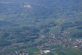
Oberbipp and Wolfisberg, aerial view from a balloon |
||
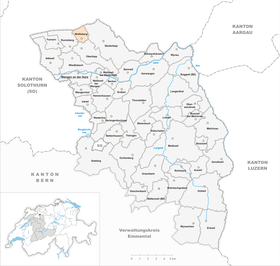
| map | ||
|
|
||
Wolfisberg was until December 31, 2019 is a municipality in the Oberaargau administrative district in the canton of Bern in Switzerland . On January 1, 2020, it merged with the Niederbipp municipality .
geography
Wolfisberg is 670 m above sea level. M. , 12 km northeast of the city of Solothurn (linear distance). The village extends in a promising location on a terrace on the south side of the foremost Jura chain (Leberberg), 200 m above the plane of the Swiss Midland , above Oberbipp , in the region Oberaargau .
The area of the 2.4 km² former municipal area covers a section of the southern slopes of the Jura. The slope is the product of a huge landslide that occurred at the end of the crack ice age, when the ice age's stabilizing effect ceased to exist with the retreat of the ice age Rhone glacier . As a result, the southern limb of the anticline of the first Jura chain slipped, leaving a large landslide zone.
The Wolfisberg area is drained in the southwest by the Dorfbach von Oberbipp directly to the Aare , while in the eastern part the Bipperbach provides drainage to the Dünnern . The community soil extends from the landslide terrace northwards over the steep slope to the Malmkalk ridge of the Lebernberg with various rock faces. On the Höllchöpfli (also Hällchöpfli ) is at 1231 m above sea level. M. reached the highest point of Wolfisberg. The western boundary of the municipality runs over the Ankehubel ( 1085 m above sea level ) and the Randfluh . In 1997, 5% of the municipal area was accounted for by settlements, 50% for forests and woodlands and 45% for agriculture.
Some individual farms belong to Wolfisberg. Neighboring communities of Wolfisberg were Niederbipp , Oberbipp and Rumisberg in the canton of Bern and Matzendorf and Laupersdorf in the canton of Solothurn .
population
With 184 inhabitants (as of December 31, 2018) Wolfisberg was one of the small communities in the canton of Bern. 96.6% of the residents were German-speaking, 1.7% Albanian-speaking and 1.2% spoke French (as of 2000). The population of Wolfisberg was 285 in 1850, compared to 217 in 1900. In the course of the 20th century, the population decreased by a further 40% to 135 people until 1980 due to strong emigration. Since then, the population has increased significantly again.
economy
Wolfisberg was a predominantly agricultural village until the second half of the 20th century . Even today, arable farming as well as dairy farming and animal husbandry play an important role in the income structure of the population. Some other jobs are available in local small businesses and in the service sector. In the last few decades the village has developed into a residential community thanks to its attractive location. Many employed people are therefore commuters who mainly work in the larger communities along the southern foot of the Jura between Solothurn and Olten .
traffic
Wolfisberg is located away from the larger through axes on a connecting road from Niederbipp to Rumisberg . The nearest connection to the A1 motorway (Bern-Zurich) is around 5 km from the town center. Wolfisberg is connected to the public transport network by a bus line that runs from Niederbipp to Rumisberg.
history
The place was first mentioned in a document in 1332 under the name Wolfisperg . The names Wulfisperg (1464), Wüllfflysperg (1479) and Wulfysperg (1518) appeared later . The place name goes back to the Old High German personal name Vulfo or Wolfi and therefore means mountain des Vulfo / Wolfi .
Since the Middle Ages, the area of Wolfisberg has been under the Landgraviate of Buchsgau , which was administered by the Counts of Frohburg . It belonged to the rule of Bipp and since the beginning of the 14th century to the office of Erlinsburg, which came to the Counts of Neuchâtel-Nidau in 1332. Wolfisberg also shared the fate of the Bipp rule, which experienced numerous changes of ownership. As part of this rule, the village came under the joint administration of Bern and Solothurn in 1413. After the division of Buchsgau, Wolfisberg came under the sole sovereignty of Bern in 1463 and was assigned to the Bipp district.
After the collapse of the Ancien Régime (1798), Wolfisberg belonged to the district of Wangen during the Helvetic period and from 1803 to the Oberamt Wangen, which received the status of an official district with the new cantonal constitution of 1831 and was integrated into the administrative district of Oberaargau on January 1, 2010.
Web links
- Official website of the Wolfisberg community
- Anne-Marie Dubler : Wolfisberg. In: Historical Lexicon of Switzerland .
Individual evidence


