
Laupersdorf
| Laupersdorf | |
|---|---|
 |
|
| State : |
|
| Canton : |
|
| District : | Thal |
| BFS no. : | 2426 |
| Postal code : | 4712 |
| Coordinates : | 616 088 / 240511 |
| Height : | 493 m above sea level M. |
| Height range : | 480–1213 m above sea level M. |
| Area : | 15.50 km² |
| Residents: | 1813 (December 31, 2018) |
| Population density : | 117 inhabitants per km² |
| Website: | www.laupersdorf.ch |
 View of Laupersdorf from the hiking trail to Höngen, 2016 |
|
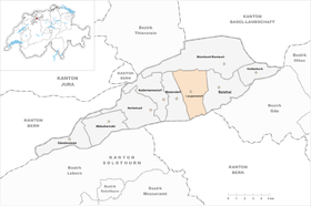
| Location of the municipality | |
  |
|
Laupersdorf is a municipality in the Thal district in the canton of Solothurn in Switzerland .
geography

Laupersdorf is 493 m above sea level. M. , 3 km west of the district capital Balsthal ( linear distance ). The Bachzeilendorf extends in a protected location in the hollow of the Dorfbach on the sunny side on the northern edge of the Balsthalertal, at the foot of the Brunnersberg range in the Solothurn Jura .
The area of the community area of 15.5 km² comprises a section in the central part of the Balsthaler or Dünner valley, a longitudinal valley in the Solothurn Jura. The central part of the area is formed by the approximately 500 to 1000 m wide flat valley plain of the Dünnern , which rises to the south to the hill of the Enerholz . To the south, the municipal ban extends to the anticline of the Weissenstein chain and includes the densely wooded steep slope of the Leberen . On the ridge area of this Jura chain are the pastures of the Schwängimatt , the Rosschopf ( 1115 m above sea level. M. ) and the Höllchöpfli , at which 1215 m above sea level. M. the highest elevation of Laupersdorf is reached.
The Mulde von Laupersdorf, through which the Dorfbach flows, connects to the north of the Dünnern valley. Further to the north, the municipality extends over the mostly steep forest slope (the so-called Sunnenberg ), which is partly covered with rocks, to the anticline of the Brunnersberg range with the heights of Klein Brunnersberg ( 1120 m above sea level ), Laupersdörfer Stierenberg ( 1105 m) above sea level ) and Bremgarten ( 960 m above sea level ). In 1997, 5% of the municipal area was in settlements, 47% in forests and woodlands, 47% in agriculture and a little less than 1% was unproductive land.
Laupersdorf includes the Vorstatt district ( 493 m above sea level ) on the main road in the Dünnern valley, the hamlet of Höngen ( 664 m above sea level ) on a terrace on the southern slope of the Brunnersberg range above Balsthal, the scattered settlement Enerholz ( 507 m above sea level). M. ) slightly increased south of the Dünnern at the foot of the Leberen as well as various individual farms in the valley and Sennhöfe on the Jura heights. Neighboring communities of Laupersdorf are Matzendorf , Mümliswil-Ramiswil and Balsthal in the canton of Solothurn and Niederbipp in the canton of Bern .
population
With 1,813 inhabitants (as of December 31, 2018), Laupersdorf is one of the medium-sized communities in the canton of Solothurn. 93.5% of the residents speak German, 1.9% speak Serbo-Croatian and 1.6% speak Albanian (as of 2000). The population of Laupersdorf was 720 inhabitants in 1850 and 862 in 1900. In the course of the 20th century the population continued to grow. After a temporary decline in the 1960s, a significant increase in population has been recorded again since 1970 (1369 inhabitants).
politics
In 2009 the municipal council was reduced from 12 to 9 council mandates. At the same time, the Swiss People's Party was able to be represented on the Laupersdorf municipal council for the first time.
| Political party | 2013-2017 | (+/-) | 2009-2013 |
| Christian Democratic People's Party | 5 | 5 | |
|
FDP. The Liberals ( Free Democratic Party until 2009 ) |
2 | 2 | |
| Swiss People's Party | 2 | 2 |
economy
Up until the second half of the 20th century, Laupersdorf was primarily a village characterized by agriculture . In the course of the 16th century, the heights of the Brunnersberg range were cleared, extensive summer pastures were created for the cattle and several dairy farms were built. Even today, arable farming and fruit growing in the lower elevations as well as dairy farming and cattle breeding in the upper parts of the municipality have an important place in the income structure of the population.
Numerous other jobs are available in local small businesses and in the service sector. Plastics processing, mechanical engineering, metal construction, construction, mechanical workshops, a cardboard factory and a rope factory are all represented in Laupersdorf. In the last few decades the village has also developed into a residential community. Many employed people are therefore commuters who mainly work in Balsthal and in the Olten-Solothurn area.
traffic
The community is very well developed in terms of transport. It is located on the main road from Oensingen to Moutier . Laupersdorf is connected to the public transport network through a post bus course , which covers the route from Balsthal to Gänsbrunnen .
history
The place was first mentioned in documents in 968 under the name Luiperestorf . The names Loppestorf (1179), Luoperthurf (1194) and Loperstorf (1236) appeared later . The place name is derived from the Old High German personal name Loubwar . In the High Middle Ages , Laupersdorf initially belonged to the Moutier-Grandval Monastery before it came under the rule of Neu-Falkenstein. In 1420 the place came under the rule of Solothurn through purchase and was assigned to the Landvogtei Falkenstein. The next place of justice was Matzendorf.
After the collapse of the Ancien Régime (1798), Laupersdorf was assigned to the Balsthal-Thal district. In the 19th century, especially from 1850 to around 1870, the valley was affected by severe poverty and famine, so that many residents had to emigrate. Until around 1870, the ore deposits near Laupersdorf were mined for Von Rollsche Eisenwerk in Klus.
coat of arms
The village coat of arms is a white 8 on a red background. The 8 has a military background: According to a source from 1689, the Thaler communities belonged to the fourth and fifth companies of the second regiment of the Solothurn militia army . At that time the number 4 was written like an 8 open at the bottom.
With the exception of Holderbank , Mümliswil-Ramiswil and Gänsbrunnen , all the coats of arms of the Thaler communities appear to be in this tradition. But only those from Laupersdorf and Balsthal have this figure eight. In the coats of arms of Aedermannsdorf , Herbetswil , Matzendorf and Welschenrohr , the main motif is an angle - a variant of the old 5 - each with a different color and shape.
Attractions
The St. Martin's Church in Laupersdorf was probably founded in the 7th century by the Moutier-Grandval monastery. The church was given its present form when it was rebuilt in 1860. In the town center, some farmhouses from the 18th and 19th centuries have been preserved. In Höngen is the St. Jacob's Chapel , which was built in its current location in 1715 and replaced an older building elsewhere.
photos
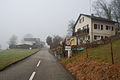
Entrance to Laupersdorf in the morning fog, January 2011
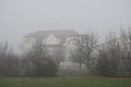
Schoolhouse of Laupersdorf in the fog

Restaurant Vorstädtli


literature
- Gottlieb Loertscher: The art monuments of the canton of Solothurn, Volume III: The districts of Thal, Thierstein, Dorneck. (= Art Monuments of Switzerland. Volume 38). Edited by the Society for Swiss Art History GSK. Bern 1957, DNB 750089342 .
Web links
- Official website of the municipality of Laupersdorf
- Aerial views of the village
- Albert Vogt: Laupersdorf. In: Historical Lexicon of Switzerland .
Individual evidence
- ↑ Permanent and non-permanent resident population by year, canton, district, municipality, population type and gender (permanent resident population). In: bfs. admin.ch . Federal Statistical Office (FSO), August 31, 2019, accessed on December 22, 2019 .
- ↑ a b Laupersdorf municipal council from April 14, 2013 ( page no longer available , search in web archives ) Info: The link was automatically marked as defective. Please check the link according to the instructions and then remove this notice.
- ↑ a b Municipal Council Laupersdorf - Meeting of the Municipal Council on Monday, August 10, 2009 ( page no longer available , search in web archives ) Info: The link was automatically marked as defective. Please check the link according to the instructions and then remove this notice. (PDF; 31 kB)