
Goose fountain
| Goose fountain | |
|---|---|
 |
|
| State : |
|
| Canton : |
|
| District : | Thal |
| BFS no. : | 2423 |
| Postal code : | 4716 |
| Coordinates : | 602 649 / 234777 |
| Height : | 732 m above sea level M. |
| Height range : | 718–1330 m above sea level M. |
| Area : | 11.45 km² |
| Residents: | 85 (December 31, 2018) |
| Population density : | 7 inhabitants per km² |
| Website: | www.gaensbrunnen.ch |
 Goose fountain, view of the church |
|
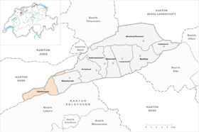
| Location of the municipality | |
  |
|
Gänsbrunnen is a municipality in the Thal district in the canton of Solothurn in Switzerland . The French name of the village is Saint-Joseph .
geography
Gänsbrunnen is 732 m above sea level. M. , 8 km northwest of the canton capital Solothurn (air line). The scattered settlement community extends in a basin of the Bantlibach , in the extreme west of the Juralängstal of Balsthal, at the northern foot of the Weissenstein range in the Solothurn Jura .
The area of the 11.4 km² municipal area includes a section of the Solothurn Jura with strong relief. The central part is the Gänsbrunnen basin, in which the Bantlibach and Rüschbach meet and flow as La Raus to the northwest through the Gänsbrunnen gorge to the Birs . To the west of this basin, a large part of the catchment area of the Bantlibach with the Binzberg (pass crossing into the Vallée de Tavannes ) belongs to Gänsbrunnen. The northern border is formed by the Oberdörferberg ( 1297 m above sea level ) on the anticline of the Graitery , in the south the border does not run on the main ridge of the first Jura chain, but on the ridge to the north with steep layers of Malm limestone . The vault of the Weissenstein anticline has broken up here and the progressive erosion created several half-cycles .
To the east of the Gänsbrunnen valley basin, the community area extends over a low pass into the source area of the Dünnern . This is flanked in the south by the Dilitschkopf (at 1333 m above sea level, the highest elevation of Gänsbrunnen), which belongs to the Weissenstein , in the north by the Walenmatt ( 1239 m above sea level ). Its slopes are densely forested and partially crossed by ledges. In a long, narrow corner, which is only about 50 meters wide at its thinnest point, the community soil extends from the Walenmatt to the northeast over the mountain pastures Malsenberg and Harzer ( 1144 m above sea level ) into the Harzergraben above Welschenrohr. In 1997, 2% of the municipal area was accounted for by settlements, 67% for forests and woodlands and 31% for agriculture.
Gänsbrunnen includes various individual farms in the valley and Sennhöfe on the Jura heights. Neighboring communities of Gänsbrunnen are Herbetswil , Welschenrohr , Oberdorf and Selzach in the canton of Solothurn and Court , Eschert , Grandval , Crémines , Corcelles and Seehof in the canton of Bern .
population
With 85 inhabitants (as of December 31, 2018), Gänsbrunnen is one of the smallest communities in the canton of Solothurn. 95.2% of the residents are German-speaking and 4.8% French-speaking (as of 2000). The population of Gänsbrunnen was 176 inhabitants in 1850 and 153 in 1900. With the construction and opening of the Moutier-Gänsbrunnen-Solothurn railway line, the population rose to 214 by 1910. Since 1950 (193 inhabitants) the population has decreased by over 50% due to strong emigration.
economy
Gänsbrunnen has been a village that has been dominated by mining and iron processing since the 16th century . Today agriculture dominates in the municipality , in particular dairy farming and cattle breeding have an important place in the employment structure of the population. Some other jobs are available in local small businesses and in the service sector. A large quarry is being exploited north of the village.
traffic
The community has good transport links. It is located on the main road 30 from Oensingen to Moutier . On August 1, 1908, the railway line of the Solothurn-Münster-Bahn from Solothurn through the 3.8 km long Weissenstein tunnel to Moutier was put into operation. The Gänsbrunnen station at the north portal of the tunnel is located in the gorge below the village, already in the municipality of Crémines . The scattered settlement community is connected to the public transport network through a post bus course , which covers the route from Balsthal to Gänsbrunnen.
history
The place was first mentioned in documents in 1400 under the name Gensprunnen ; from 1423 the name Gensbrunnen has been handed down. Gänsbrunnen belonged to the Moutier-Grandval provost in the Middle Ages . In 1569 the village was bought by Solothurn and the Falkenstein bailiff was incorporated. Ore mining and iron processing on a small scale already existed in the 16th century. The first iron smelter in Gänsbrunnen was founded in 1693. There was also a glassworks (around 1560–1625) and several mills on the grounds of the Schafmatt Berghof owned by the Hug family at that time. Because of its location on the border with the Principality of Basel and from 1797 on the border to France ( Département du Mont-Terrible and Haut-Rhin from 1800 to 1815), Gänsbrunnen used to be an important border station with a customs office.
After the collapse of the Ancien Régime (1798), Gänsbrunnen was assigned to the Balsthal-Thal district. From 1805 to 1845, the Ludwig Von Roll & Cie. operated a blast furnace that was later relocated to Choindez because iron ore mining was no longer profitable. Mining was given up; however, a limestone quarry has been exploited since 1908.
The Gänsbrunnen barrier was built during the Second World War and is considered a military monument of national importance.
Attractions
The Catholic parish church of St. Joseph was built in 1627 in the late Gothic style a little away from the village of Gänsbrunnen. It has an impressive high altar and forms a unit with the rectory (1720). The petrol pump museum, which opened in 2003, moved to Laupersdorf in 2011 . Three forts at the Gänsbrunnen barrier from the Second World War were placed under cantonal monument protection in 2004.
photos
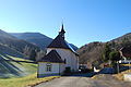
Church of St. Joseph seen from the east

Church of St. Joseph and the rectory seen from the west

Quarry and La Raus in front of the Klus

Hotel and Restaurant St. Joseph


coat of arms
- In green three (2 over 1) white geese
literature
- Gottlieb Loertscher: The art monuments of the canton of Solothurn, Volume III: The districts of Thal, Thierstein, Dorneck. (= Art Monuments of Switzerland. Volume 38). Edited by the Society for Swiss Art History GSK. Bern 1957, DNB 750089342 .
Web links
- Official website of the municipality of Gänsbrunnen
- Urban Fink: Gänsbrunnen. In: Historical Lexicon of Switzerland .
Individual evidence
- ↑ Permanent and non-permanent resident population by year, canton, district, municipality, population type and gender (permanent resident population). In: bfs. admin.ch . Federal Statistical Office (FSO), August 31, 2019, accessed on December 22, 2019 .
- ↑ https://www.pressglas-korrespondenz.de/aktuelles/pdf/pk-2013-3w-roth-schaffner-glasmacher-schweiz.pdf
- ↑ https://www.pressglas-korrespondenz.de/aktuelles/pdf/pk-2008-2w-roth-glasmacher-schweiz.pdf