
Eschert
| Eschert | |
|---|---|
 |
|
| State : |
|
| Canton : |
|
| Administrative district : | Bernese Jura |
| BFS no. : | 0692 |
| Postal code : | 2743 |
| Coordinates : | 597 078 / 236 167 |
| Height : | 596 m above sea level M. |
| Height range : | 535–1297 m above sea level M. |
| Area : | 6.58 km² |
| Residents: | 377 (December 31, 2018) |
| Population density : | 57 inhabitants per km² |
| Website: | www.eschert.ch |
 View from Eschert towards Moutier |
|
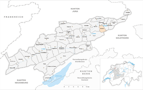
| Location of the municipality | |
  |
|
Eschert is a municipality in the Bernese Jura administrative district in the canton of Bern in Switzerland . The former German name Escherz is no longer used today.
geography
Eschert lies at 596 m above sea level. M. , 2 km east of the village of Moutier (air line). The village extends on a promontory at the northern foot of the Jura chain des Graitery , in the Jura Long Valley of Moutier, which is also called Grand Val .
The area of the 6.6 km² municipal area comprises a section of the Grand Val. The northern border of Eschert is mostly formed by the La Raus stream , which drains the valley west to the Birs . The area extends in a narrow corner to the lower southern slope of Mont Raimeux, which rises on the northern side of the valley . To the south, the municipality extends to the ridge of the Graitery chain, on the Graitery up to 1240 m above sea level. M. and on the east adjoining Oberdörferberg 1297 m above sea level. M. (highest point of Eschert). At the height of the Graitery there are Jura high pastures with the typical mighty spruce trees , which either stand individually or in groups. The steep northern slope of the Graitery is densely forested and criss-crossed by bands of limestone . Two streams have dug erosion valleys here. In 1997, 3% of the municipal area was accounted for by settlements, 55% for forests and woodlands and 42% for agriculture.
Eschert includes the Sous la Rive district ( 540 m above sea level ) in the Raus valley floor as well as several individual farms. Neighboring communities of Eschert are Court , Moutier , Belprahon and Grandval in the canton of Bern, and Gänsbrunnen in the canton of Solothurn .
population
With 377 inhabitants (as of December 31, 2018), Eschert is one of the smaller communities in the Bernese Jura . 83.7% of the residents are French-speaking, 8.2% German-speaking and 2.8% Italian-speaking (as of 2000). The population of Eschert was 208 inhabitants in 1850, and 295 in 1900. In the further course it always commuted in the range between 310 and 360 people.
politics
The voting shares of the parties on the occasion of the National Council election in 2015 were: SVP 37.6%, SP 21.1%, BDP 10.5%, FDP 9.3%, EVP 6.5%, GPS 5.5%, glp 4.6 %, EDU 2.2%, pirates 1.9%, CVP 0.7%.
economy
Until the second half of the 20th century, Eschert was mainly characterized by agriculture . In the last few decades Eschert has gradually developed into a residential community. The village offers only a few jobs outside the primary sector, especially in local small businesses (mechanics and building trade). Many workers are therefore commuters and work in Moutier.
traffic
The community can be reached by a short spur road that branches off from the main road Moutier - Balsthal . The A16 motorway is currently being built in the Moutier area , which will also touch the Eschert municipality. This motorway is to be connected to both the Swiss national road network and the French motorway network by 2015 and will have a junction east of Moutier, around 1 km from Eschert. The village is connected to public transport by a bus line that runs between Moutier, Eschert and Belprahon .
history
Eschert was first mentioned in writing in 1179 under the name Escert , later the name Echert appears . The village was under the Moutier-Grandval provost until the end of the 18th century . In 1733, numerous houses fell victim to a village fire. From 1797 to 1815 Eschert belonged to France and was initially part of the Mont-Terrible department , which was connected to the Haut-Rhin department in 1800 . By the decision of the Congress of Vienna , the place came to the canton of Bern to the district of Moutier in 1815 . Since 1967 there has been cooperation with the neighboring communities on the municipal level with regard to water supply, wastewater treatment and primary schools.
Attractions
In the rural center there are some well-preserved farmhouses and wood warehouses from the 17th to 19th centuries. Eschert does not have its own church, it belongs to the parish of Grandval.
photos

Eschert town center

Entrance to the village on Kantonsstrasse No. 30

Parish hall


Web links
- Official website of the municipality of Eschert (French)
- François Wisard: Eschert. In: Historical Lexicon of Switzerland .
Individual evidence
- ↑ Permanent resident population from STAT-TAB of the BfS , municipalities see also regional portraits 2020 on bfs.admin.ch, accessed on May 29, 2020
- ↑ Results of the community of Eschert. State Chancellery of the Canton of Bern, October 18, 2015, accessed on April 19, 2016 .
Belprahon | Champoz | Corcelles | Corgémont | Cormoret | Cortébert | Court | Courtelary | Crémines | Eschert | Grandval | La Ferrière | La Neuveville | Loveresse | Mont-Tramelan | Moutier | Nods | Orvin | Perrefitte | Péry-La Heutte | Petit-Val | Plateau de Diesse | Rebévelier | Reconvilier | Renan | Roches | Romont | Saicourt | Saint-Imier | Suction | Saules | Scolding (La Scheulte) | Seehof (Elay) | Sonceboz-Sombeval | Sonvilier | Sorvilier | Tavannes | Tramelan | Valbirse | Villeret
Former municipalities: Bévilard | Châtelat | This | La Heutte | Lamboing | Malleray | Monible | Péry | Plagne | Pontenet | Prêles | Sornetan | Souboz | Tramelan lingerie | Tramelan Dessus | Vauffelin
Canton of Bern | Administrative districts of the canton of Bern | Municipalities of the Canton of Bern