
Corgémont
| Corgémont | |
|---|---|
 |
|
| State : |
|
| Canton : |
|
| Administrative district : | Bernese Jura |
| BFS no. : | 0431 |
| Postal code : | 2606 |
| Coordinates : | 577 765 / 227112 |
| Height : | 663 m above sea level M. |
| Height range : | 652–1313 m above sea level M. |
| Area : | 17.66 km² |
| Residents: | 1706 (December 31, 2018) |
| Population density : | 86 inhabitants per km² |
| Mayor : | Etienne Klopfenstein ( SVP ) |
| Website: | www.corgemont.ch |
| Location of the municipality | |
  |
|
Corgémont is a municipality in the Bernese Jura administrative district in the canton of Bern in Switzerland .
geography

Corgémont is 663 m above sea level. M. , 10 km northwest of Biel (air line). The former street line village extends in the eastern part of the Jura Long Valley Vallon de Saint-Imier , mostly north of the river Schüss ( French Suze ).
The area of the 17.6 km² large municipal area includes a section of the wide basin of the Vallon de Saint-Imier. The central part is the approximately 500 m wide valley low of the Schüss. In the north the area extends to the anticline of the Montagne du Droit (up to 1126 m above sea level ). To the south, Corgémont extends to the height of the Chasseral chain, at 1325 m above sea level. M. the highest point of the municipality is reached. At the top of the Chasseral chain, the hard cover rock was broken up and eroded away, creating a northern and a southern ridge over the course of millions of years. In between there is an anticline valley that has already been cleared to the next hard rock layer. This vault forms a third ridge between the two outer ridges. The anticline valley has an outflow to the Schüss south of Corgémont, the deeply cut Combe du Bez . On the wide ridges of the Montagne du Droit and the Chasseral chain, there are extensive Jura high pastures with the typical, mighty spruce trees , either individually or in groups. In 1997, 6% of the municipal area was in settlements, 39% in forests and woodlands, 54% in agriculture and a little less than 1% was unproductive land.
Corgémont has numerous individual farms that are widely scattered in the valley and on the Jura heights. Neighboring municipalities of Corgémont are Tramelan , Mont-Tramelan , Cortébert , Nods , Orvin , Sonceboz-Sombeval and Tavannes .
population
| Population development | |
|---|---|
| year | Residents |
| 1850 | 753 |
| 1900 | 1,418 |
| 1910 | 1,369 |
| 1930 | 1'238 |
| 1950 | 1,285 |
| 1960 | 1,414 |
| 1970 | 1,645 |
| 1980 | 1,470 |
| 1990 | 1'534 |
| 2000 | 1,493 |
| 2010 | 1'548 |
With 1706 inhabitants (as of December 31, 2018), Corgémont is one of the larger municipalities in the Bernese Jura . 77.5% of the residents are French-speaking, 16.1% German-speaking and 3.4% Italian-speaking (as of 2000). The population of Corgémont increased sharply, especially in the second half of the 19th century. After peaking around 1970, significant emigration was observed during the economic crisis of the following years. Since 1980 there has only been minor population fluctuation.
politics
The voting shares of the parties in the 2015 National Council election were: SVP 45.5%, SP 19.4%, GPS 11.0%, FDP 8.1%, BDP 4.7%, EVP 3.3%, EDU 2.4 %, glp 1.8%, PdA 1.4%, Philipp Jutzi 1.0%, CVP 0.8%.
economy
Corgémont was an agricultural village until the end of the 18th century , but there were also some brickworks , mills and cloth- making . Watchmaking gained a foothold in Corgémont around 1800 . The watch industry helped the place to a great economic boom from the second half of the 19th century. These included a watch spring manufacture (1899–1982) and the Jules Schmoll Corgémont Watch (1907–1928), a branch of the Fontainemelon watch factory . With the crisis in the watch industry, there was a diversification of the industrial sectors to mechanics , precision mechanics and the manufacture of screw bolts. From 1932 to 1994 an enamelling factory, the Emaillerie de Corgémont SA, was of great importance. Despite the high status of industry, agriculture with cattle breeding and dairy farming , and some arable farming in the lower elevations , still play a certain role. 10% of the workforce work in this sector.
traffic
The community has good transport links. It is located on the busy main road from Biel to La Chaux-de-Fonds . On April 30, 1874, the railway line from Biel to Convers was opened with a train station in Corgémont.
history
The first written mention of the village under the name Curisgimund was on maps from the 8th century. The names Corjamont (1178), Cortgemund (1181), Corteimont (1228) and Coriemont (1326) appear later . The place name probably goes back to the court of a Gismund or Giamond . In Corgémont, the Moutier-Grandval monastery and the Saint-Imier chapter owned land. The nobles of Corgémont (also de Chalmé) ruled the place from the 12th to the 15th century. Until 1797 the village belonged to the Erguel lordship , which was subordinate to the Duchy of Basel , although the city of Biel also exerted greater influence at times. In 1530 the Reformation was introduced in Corgémont . From 1797 to 1815 the place belonged to France and was initially part of the Mont-Terrible department , which was connected to the Haut-Rhin department in 1800 . By decision of the Congress of Vienna , Corgémont came to the canton of Bern in the Courtelary district in 1815 .
Attractions
The Reformed Church of Saint-Valier was rebuilt in 1766 on the site of an earlier church from 1379. In 1925 the church was enlarged and in 1966 a new bell tower was added. The chapel of St. Niklaus von Flüe dates from 1958. In the old part of the village, the Quart-Dessous, some farms and houses from the 18th and 19th centuries have been preserved. The stained glass windows of the "Temple réformé" were designed in the 1990s by the pastor of the German-speaking Swiss community and designed by a Bernese artist. They have an enormous symbolism of both biblical and modern elements and are very handsome, especially in the morning light. Part of the glass comes from a broken light display in a small local shop.
photos
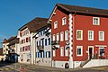
Center of Corgémont
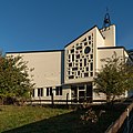
Catholic Church

reformed Church

Rectory

Salle de spectacles
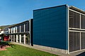
Primary school building

Secondary school house

Farmhouse with Ründe
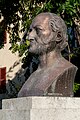
Charles-Ferdinand Morel monument


Personalities
- Charles-Ferdinand Morel , called Dean Morel (1772–1848), Reformed pastor and politician
- Georges Louis Ruedin (1870–1935), watch manufacturer
Web links
- Official website of the municipality of Corgémont (French)
- Anne Beuchat-Bessire: Corgémont. In: Historical Lexicon of Switzerland .
Individual evidence
- ↑ Permanent resident population from STAT-TAB of the BfS , municipalities see also regional portraits 2020 on bfs.admin.ch, accessed on May 29, 2020
- ^ Results of the municipality of Corgémont. State Chancellery of the Canton of Bern, October 18, 2015, accessed on April 17, 2016 .
Belprahon | Champoz | Corcelles | Corgémont | Cormoret | Cortébert | Court | Courtelary | Crémines | Eschert | Grandval | La Ferrière | La Neuveville | Loveresse | Mont-Tramelan | Moutier | Nods | Orvin | Perrefitte | Péry-La Heutte | Petit-Val | Plateau de Diesse | Rebévelier | Reconvilier | Renan | Roches | Romont | Saicourt | Saint-Imier | Suction | Saules | Scolding (La Scheulte) | Seehof (Elay) | Sonceboz-Sombeval | Sonvilier | Sorvilier | Tavannes | Tramelan | Valbirse | Villeret
Former municipalities: Bévilard | Châtelat | This | La Heutte | Lamboing | Malleray | Monible | Péry | Plagne | Pontenet | Prêles | Sornetan | Souboz | Tramelan lingerie | Tramelan Dessus | Vauffelin
Canton of Bern | Administrative districts of the canton of Bern | Municipalities of the Canton of Bern