
Tramelan
| Tramelan | |
|---|---|
 |
|
| State : |
|
| Canton : |
|
| Administrative district : | Bernese Jura |
| BFS no. : | 0446 |
| Postal code : | 2720 |
| Coordinates : | 574 459 / 230 353 |
| Height : | 900 m above sea level M. |
| Height range : | 839–1184 m above sea level M. |
| Area : | 24.83 km² |
| Residents: | 4568 (December 31, 2018) |
| Population density : | 184 inhabitants per km² |
| Mayor : | Philippe Augsburger ( FDP ) |
| Website: | www.tramelan.ch |
 Tramelan |
|
| Location of the municipality | |
  |
|
Tramelan is a municipality in the Bernese Jura administrative district in the canton of Bern in Switzerland . The former German name Tramlingen is rarely used today.
geography
Tramelan is 900 m above sea level. M. , 15 km northwest of Biel (air line). The community extends in a wide basin of the Trame stream in the Jura north of the Montagne du Droit and on the south-eastern edge of the Franches-Montagnes ( Freiberge in German ).
The 24.9 km² municipal area covers the upper valley area of the Trame, which lies between the anticline of Montbautier ( 1184 m above sea level ) in the north and that of Montagne du Droit (up to 1110 m above sea level ) in the south . The ridge of the Montbautier forms the highest point of Tramelan. The western part of the municipality is occupied by the gently undulating plateau of the Franches-Montagnes (970 to 1050 m above sea level ). Here, boggy depressions, mostly without drainage above ground, alternate with limestone peaks , and the La Tourbière peat bog lies at the very western edge . On the Plateaujura as well as on the ridge of the Montbautier there are extensive Jura high pastures with the typical mighty spruce trees , which either stand individually or in groups. The area is drained by the Trame to the east to the Birs . In 1997, 8% of the municipal area was in settlements, 32% in forests and woodlands, 59% in agriculture and a little more than 1% was unproductive land.
Tramelan includes the hamlets of Les Reussilles ( 1011 m above sea level ), Les Gerines ( 1038 m above sea level ) and Le Cernil ( 1005 m above sea level ), all located on the Franches-Montagnes plateau, as well as numerous Individual farms that are widely scattered in the valley floor of the Trame and on the Jura heights. Neighboring municipalities of Tramelan are Mont-Tramelan , Corgémont , Tavannes and Saicourt in the canton of Bern as well as Les Genevez , Montfaucon , Le Bémont , Saignelégier and La Chaux-des-Breuleux in the canton of Jura .
population
| Population development | |
|---|---|
| year | Residents |
| 1850 | 2,551 |
| 1900 | 5,559 |
| 1910 | 5'267 |
| 1930 | 5,000 |
| 1950 | 4,951 |
| 1960 | 5,567 |
| 1970 | 5,549 |
| 1980 | 4,733 |
| 1990 | 4,479 |
| 2000 | 4,165 |
| 2010 | 4,254 |
With 4568 inhabitants (as of December 31, 2018), Tramelan is the third largest municipality in the Bernese Jura . 86.3% of the residents are French-speaking, 8.2% German-speaking and 2.4% Italian-speaking (as of 2000). The population of Tramelan fluctuated between 1890 and 1970 between 5000 and 5600 people. Since then, it has decreased significantly due to strong emigration.
politics
The legislature is called conseil général (German General Council ) and has 37 members. They are elected by the people in proportion for four years. The graphic on the right shows the current distribution of seats in the General Council (as of April 2016).
Tramelan's executive is the conseil municipal ( municipal council ), which is elected for a period of four years. It consists of seven people including the mayor . For the 2015-2018 legislature, it has the following party-political composition: SP 3 seats, FDP 2 seats, SVP 1 seat, Groupe débat 1 seat. Mayor is Philippe Augsburger (FDP; as of April 2016).
The voting shares of the parties in the 2015 National Council election were: SP 35.5%, SVP 28.2%, FDP 9.7%, EPP 7.3%, GPS 6.6%, BDP 3.5%, EDU 3.3 %, PdA 1.9%, CVP 1.5%, glp 0.8%.
economy
Until the first half of the 19th century, Tramelan was mainly dominated by agriculture and peat was cut in the bog of La Tourbière from time to time . After that, with the introduction of the watch industry, a rapid economic upswing set in and the population grew rapidly. Tramelan flourished in the first half of the 20th century in the watchmaking and mechanical engineering industries. Due to the crisis in the watch industry from 1970 onwards, the place suffered from the loss of many jobs and the population decreased. Today there are only a few jobs left in the watchmaking sector ( Auguste Reymond , Armand Nicolet , Davosa and Nitella ). A machine tool factory is of the greatest importance; companies in electronics , precision mechanics and metal construction offer numerous other jobs . Agriculture still plays an important role, with livestock and dairy farming predominating. Every year in August there is a national horse show. Tramelan has an interregional training center that opened in 1991.
The area around Tramelan is a recreational and hiking area. In winter you can ski on the northern slope of the Montagne du Droit and cross-country skiing is possible on the Jura plateau . Tramelan also has an outdoor swimming pool.
traffic
The community is very well developed in terms of traffic. It is located on the cantonal road from Tavannes to Saignelégier .
On August 16, 1884, the Tavannes – Tramelan Railway was inaugurated. On December 16, 1913, the Tramelan-Breuleux-Noirmont Railway , the western continuation to Le Noirmont, opened . The Tavannes – Tramelan – Le Noirmont railway line has been operated by the Chemins de fer du Jura since 1944 . In addition to the train station, there are four other stops Tramelan-Dessous , Tramelan-Chalet, Les Reussilles and Le Pied-d'Or in the municipality. The Tramelan-Collège stop is not in operation. Postbus courses from Tramelan to Saint-Imier , to Saignelégier and to Glovelier ensure the fine distribution of public transport .
art
- Tramlabulle Comics Festival in Tramelan
history

Tramelan was first mentioned in 1178 under the name Trameleins . In 1297 the name Tramelans followed and the current place name has existed since 1317. In addition to Tramlingen , Tremlingen and Tremmlingen have come down as German names . The place name probably goes back to the Burgundian personal name Thrasamal , which means tireless warrior . Tramelan originally belonged to the Saint-Imier chapter, but was transferred to the Duchy of Basel during the Reformation . During the Thirty Years War , the place was affected. From 1797 to 1815 Tramelan belonged to France and was initially part of the Mont-Terrible department , which was linked to the Haut-Rhin department in 1800 . As a result of the decision of the Congress of Vienna , the place came to the canton of Bern in the Courtelary district in 1815 . In 1839 part of Tramelan was devastated by a village fire.
Attractions
After the fire, the reformed village church was rebuilt in 1843, and a comprehensive renovation and enlargement was carried out in 1957/1958. The Saint-Michel Catholic Church dates from 1909, a basilica that used elements of neo-Gothic and native style . The secondary school building was also built in the Heimat style (1912).
The numerous cubic buildings of the tenement houses, which were built at the end of the 19th and beginning of the 20th century, gave Tramelan an urban character. In the oldest part of the village, in Tramelan-Dessous, there are still some farmhouses from the 17th and 18th centuries. The numerous typical Freiberg mountain farms with whitewashed facades and large roofs, especially in the hamlet of Le Cernil, located on the plateau of the Jurassic plateau date from the same period.
photos

Tramelan

Tramelan
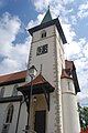
Tramelan Catholic Church
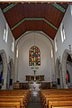
Interior of the Catholic Church of Tramelan

Town house in Tramelan

Reformed Church of Tramelan

Tramelan secondary school

Former Damas watch factory

Former Record Watch factory

Aquarium restaurant at Les Reussilles train station

Level crossing in Les Reussilles


_017.JPG)
Personalities
- Charles Albert Gobat (1843–1914), Nobel Peace Prize Laureate
- Virgile Rossel (1858–1933), lawyer (ZGB, 1912), National Councilor (President 1910), federal judge (1912–1932), author
- Roland Béguelin (1921–1993), community clerk, journalist, politician, in Delémont co-founder and secretary of the Jurassic freedom movement Rassemblement Jurassien
- André Ramseyer (1914–2007), sculptor
- Jacques Rossel (1915–2008), President of the Basel Mission
- Moussia von Wattenwyl (* 1971), Grand Councilor (Greens)
Web links
- Official website of the municipality of Tramelan (French)
- Christine Gagnebin-Deacon: Tramelan. In: Historical Lexicon of Switzerland .
Individual evidence
- ↑ Permanent resident population from STAT-TAB of the BfS , municipalities see also regional portraits 2020 on bfs.admin.ch, accessed on May 29, 2020
- ^ Conseil général. (No longer available online.) Commune de Tramelan, formerly in the original ; Retrieved April 18, 2016 (French). ( Page no longer available , search in web archives ) Info: The link was automatically marked as defective. Please check the link according to the instructions and then remove this notice.
- ↑ Conseil municipal. (No longer available online.) Commune de Tramelan, formerly in the original ; Retrieved April 18, 2016 (French). ( Page no longer available , search in web archives ) Info: The link was automatically marked as defective. Please check the link according to the instructions and then remove this notice.
- ↑ Results of the Tramelan municipality. State Chancellery of the Canton of Bern, October 18, 2015, accessed on April 17, 2016 .
Belprahon | Champoz | Corcelles | Corgémont | Cormoret | Cortébert | Court | Courtelary | Crémines | Eschert | Grandval | La Ferrière | La Neuveville | Loveresse | Mont-Tramelan | Moutier | Nods | Orvin | Perrefitte | Péry-La Heutte | Petit-Val | Plateau de Diesse | Rebévelier | Reconvilier | Renan | Roches | Romont | Saicourt | Saint-Imier | Suction | Saules | Scolding (La Scheulte) | Seehof (Elay) | Sonceboz-Sombeval | Sonvilier | Sorvilier | Tavannes | Tramelan | Valbirse | Villeret
Former municipalities: Bévilard | Châtelat | This | La Heutte | Lamboing | Malleray | Monible | Péry | Plagne | Pontenet | Prêles | Sornetan | Souboz | Tramelan lingerie | Tramelan Dessus | Vauffelin
Canton of Bern | Administrative districts of the canton of Bern | Municipalities of the Canton of Bern