
La Ferrière BE
| BE is the abbreviation for the canton of Bern in Switzerland and is used to avoid confusion with other entries of the name La Ferrière . |
| La Ferrière | |
|---|---|
 |
|
| State : |
|
| Canton : |
|
| Administrative district : | Bernese Jura |
| BFS no. : | 0435 |
| Postal code : | 2333 |
| Coordinates : | 558 619 / 221 642 |
| Height : | 1005 m above sea level M. |
| Height range : | 609–1163 m above sea level M. |
| Area : | 14.16 km² |
| Residents: | 534 (December 31, 2018) |
| Population density : | 38 inhabitants per km² |
| Mayor : | Bernard Tschäppät ( PS ) |
| Website: | www.laferriere.ch |
| Location of the municipality | |
  |
|
La Ferrière is a municipality in the Bernese Jura administrative district in the canton of Bern in Switzerland .
geography
La Ferrière is located at 1005 m above sea level. M. , seven kilometers east-northeast of La Chaux-de-Fonds (beeline). The village extends on a slope inclined to the north in the extreme southwest of the Jura plateau of the Franches-Montagnes (German Freiberge ), east of the Combe de Valanvron valley .
The area of the 14.2 km² large municipal area comprises part of the slightly undulating plateau of the Plateaujura, on which boggy, mostly above-ground drainage-free depressions alternate with limestone peaks . In the south the area extends to the Jura chain of the Montagne du Droit , on which at 1150 m above sea level. M. is the highest point of La Ferrière. On this chain there are extensive Jura high pastures with the typical mighty spruce trees , which either stand individually or in groups. The western part of the municipality includes the Combe de Valanvron valley, cut deep into the Plateaujura and drained by the Ronde brook . La Ferrière extends in a narrow corner to the northwest almost to the banks of the Doubs near the Biaufond border crossing . In 1997, 4% of the municipal area was in settlements, 34% in forests and woodland, 61% in agriculture and a little less than 1% was unproductive land.
La Ferrière includes the hamlet of La Basse Ferrière ( 982 m above sea level ) north of the village as well as numerous individual farms that are widely scattered on the Jura heights. Neighboring communities of La Ferrière are Renan and Sonvilier in the canton of Bern, Les Bois in the canton of Jura and La Chaux-de-Fonds in the canton of Neuchâtel .
The immediate proximity of the westernmost point of La Ferrière to France often leads to the assumption on large Swiss national maps that the canton of Bern borders France and is therefore a border canton. On detailed community maps, however, you can see that there are a few hundred meters between the French national territory and La Ferrière and that the cantons of Neuchâtel and Jura border each other at this point.
population
With 534 inhabitants (as of December 31, 2018), La Ferrière is one of the medium-sized communities in the Bernese Jura . 81.8% of the residents are French-speaking, 16.6% German-speaking and 1.0% Italian-speaking (as of 2000). The population of La Ferrière was 796 in 1850 and 1040 in 1870. After that it had decreased by 50% to 525 inhabitants by 1930. Since then, only minor fluctuations have been recorded.
politics
The voting shares of the parties at the 2015 National Council election were: SVP 37.7%, SP 18.9%, GPS 9.2%, FDP 6.8%, BDP 6.7%, EPP 6.3%, glp 5.2 %, EDU 4.1%, PdA 3.9%, CVP 0.0%.
economy
La Ferrière was an agricultural village until the middle of the 19th century . Then the watch industry was introduced, which helped the place to an economic boom. With the crisis in watchmaking after 1930, the number of employees in this branch of industry fell markedly. Today some smaller businesses and local businesses offer jobs. Agriculture with cattle breeding and dairy farming also plays an important role again, around 40% of the workforce is employed in agriculture.
traffic
The community is located on the main road 18 from Delémont to La Chaux-de-Fonds. At La Cibourg, south of the village, it joins the direct traffic connection from La Chaux-de-Fonds to the Vallon de Saint-Imier ( main road 30 ). On December 7, 1892, the Saignelégier – La Chaux-de-Fonds-Bahn , a predecessor of the Chemins de fer du Jura , opened with a station in La Ferrière.
history

The settlement was only founded in 1590 by residents from the Val de Ruz and for a long time was called Les Hautes Montagnes d'Erguel . The village belonged to the Erguel rule under the Principality of Basel . It was occupied by Swedish troops during the Thirty Years' War and sacked in 1639. In 1767 the place got the castle Erguel together with the land holdings from the prince-bishop of Basel. La Ferrière sold this in 1828 to the municipality of Sonvilier.
From 1797 to 1815 the community belonged to France and only now took the name La Ferrière. It was initially part of the Mont-Terrible department , which was connected to the Haut-Rhin department in 1800 . As a result of the decision of the Congress of Vienna , La Ferrière came to the canton of Bern in the Courtelary district in 1815 .
Attractions
The reformed village church dates from 1864. Before 1861, La Ferrière belonged to the parish of Renan. The Hôtel du Cheval Blanc was built in 1688. In the vicinity of La Ferrière there are numerous typical farmhouses of the High Jura from the 17th and 18th centuries. The house of the naturalist Abraham Gagnebin (1707–1800), which is included in the list of cultural assets of national importance in the canton of Bern , has been preserved in the village .
photos
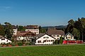
View to the village center

reformed Church

Primary school building

Multipurpose hall

Hotel du Cheval Blanc

Abraham Gagnebin's home

Hôtel Pension La Chaux-d'Abel

Roundabout, “Tete de Moine”, Girolle


Web links
- Anne Beuchat-Bessire: Ferrière, La. In: Historical Lexicon of Switzerland .
- Official website of the municipality of La Ferrière
Individual evidence
- ↑ Permanent resident population from STAT-TAB of the BfS , municipalities see also regional portraits 2020 on bfs.admin.ch, accessed on May 29, 2020
- ↑ Results of the commune of La Ferrière. State Chancellery of the Canton of Bern, October 18, 2015, accessed on April 17, 2016 .
Belprahon | Champoz | Corcelles | Corgémont | Cormoret | Cortébert | Court | Courtelary | Crémines | Eschert | Grandval | La Ferrière | La Neuveville | Loveresse | Mont-Tramelan | Moutier | Nods | Orvin | Perrefitte | Péry-La Heutte | Petit-Val | Plateau de Diesse | Rebévelier | Reconvilier | Renan | Roches | Romont | Saicourt | Saint-Imier | Suction | Saules | Scolding (La Scheulte) | Seehof (Elay) | Sonceboz-Sombeval | Sonvilier | Sorvilier | Tavannes | Tramelan | Valbirse | Villeret
Former municipalities: Bévilard | Châtelat | This | La Heutte | Lamboing | Malleray | Monible | Péry | Plagne | Pontenet | Prêles | Sornetan | Souboz | Tramelan lingerie | Tramelan Dessus | Vauffelin
Canton of Bern | Administrative districts of the canton of Bern | Municipalities of the Canton of Bern