
Les Bois
| Les Bois | |
|---|---|
 |
|
| State : |
|
| Canton : |
|
| District : | Franches-Montagnes |
| BFS no. : | 6742 |
| Postal code : | 2336 |
| Coordinates : | 559 592 / 225 341 |
| Height : | 1034 m above sea level M. |
| Height range : | 537–1120 m above sea level M. |
| Area : | 24.71 km² |
| Residents: | 1241 (December 31, 2018) |
| Population density : | 50 inhabitants per km² |
| Website: | www.lesbois.ch |
| Location of the municipality | |
  |
|
Les Bois is a municipality in the Franches-Montagnes district (German: Freiberge ) in the canton of Jura in Switzerland . The former German name Rudisholz is no longer used today.
geography

Les Bois is 1034 m above sea level. M. , 11 km northeast of La Chaux-de-Fonds (linear distance). The village is located on a gently sloping hillside to the south on the Jura plateau of the southwestern Freiberge (French Freiberge ).
With an area of 24.7 km², the largest municipal area in the canton of Jura includes a section of the gently undulating plateau of the Plateau Jura, on which boggy, mostly above-ground drainage-free depressions alternate with limestone peaks . This plateau forms an extensive pasture area, which is loosened up and divided by large spruce trees standing individually or in groups . The highest point of Les Bois is 1120 m above sea level. M. at the height north of Le Peu-Claude. The north-western boundary is formed by the canyon-like valley of the Doubs , cut into the Plateau Jura , whose valley flanks are densely forested and criss-crossed by ledges. In the west, the municipality extends to the Combe du Valanvron , another erosion valley that flows into the Doube valley at Biaufond. In 1997, 4% of the municipal area was in settlements, 38% in forests and woodland, 57% in agriculture and around 1% was unproductive land.
Les Bois includes the nine hamlets of Le Boéchet ( 1033 m above sea level ), Le Peu-Claude ( 1105 m above sea level ), Les Prailats ( 950 m above sea level ), Sous les Rangs ( 1010 m above sea level). M. ) and Le Cerneux-Godat ( 938 m above sea level ), Le Bois-Français, Les Rosées, La Large-Journée all located on the plateau of the Freiberg mountains, the hamlet of Biaufond ( 610 m above sea level ) in the Doubstal at the mouth of the Combe du Valanvron, as well as numerous individual farms. Neighboring municipalities of Les Bois are Le Noirmont in the canton of Jura, Saint-Imier , Sonvilier and La Ferrière in the canton of Bern , La Chaux-de-Fonds in the canton of Neuchâtel and Fournet-Blancheroche and Charquemont in neighboring France .
population
| Population development | |
|---|---|
| year | Residents |
| 1850 | 1339 |
| 1870 | 1697 |
| 1900 | 1456 |
| 1910 | 1323 |
| 1930 | 1153 |
| 1950 | 1064 |
| 1960 | 1098 |
| 1970 | 1110 |
| 1980 | 917 |
| 1990 | 974 |
| 2000 | 1029 |
With 1,241 inhabitants (as of December 31, 2018), Les Bois is one of the larger municipalities in the canton of Jura. 93.1% of the residents are French-speaking, 4.5% German-speaking and 0.6% Italian-speaking (as of 2000). From the second half of the 19th century until around 1950, the population of Les Bois decreased sharply. After that, relatively minor fluctuations were recorded.
economy
Les Bois is a predominantly agricultural village with a lot of pasture land, important dairy farming and cattle breeding . At the beginning of the 19th century, textile processing and watchmaking developed in Les Bois, first at home and later in factories. Today watchmaking and small businesses offer jobs in the secondary sector. Many workers are commuters and work in the city of La Chaux-de-Fonds .
traffic
The municipality is located on the main road from Delémont to La Chaux-de-Fonds. On December 7, 1892, the Saignelégier – La Chaux-de-Fonds-Bahn , a predecessor of the Chemins de fer du Jura with stations in Les Bois and Le Boéchet, opened.
history
The Les Bois settlement is first mentioned in 1484 as Des Boix . One of the first settlers at the end of the 15th century was Jean Ruedin, after whom the place was named Les Bois Jean Ruedin from the 16th to the 18th century . The former German name Rudisholz also goes back to this settler. Les Bois belonged to the dominion of Freiberge, which was subordinate to the Principality of Basel . The village was ravaged by the plague several times in the 16th and 17th centuries . The place was occupied during the Thirty Years War . From 1793 to 1815, Les Bois belonged to France and was initially part of the Département du Mont-Terrible , from 1800 connected to the Département Haut-Rhin . By decision of the Congress of Vienna , the place came to the canton of Bern in 1815 and on January 1, 1979 to the newly founded canton of Jura. The efforts of the residents of Le Cerneux-Godat to form an independent community failed in 1815 and 1871.
Attractions
The parish church of Sainte-Foy, the first building of which dates from 1627, was extensively renovated and rebuilt in the neoclassic style in 1832-34 . Until 1596, Les Bois belonged to the parish of Montfaucon , then to Le Noirmont ; since 1619 the place forms its own parish. Some typical houses from the 18th and 19th centuries are part of the townscape. In the hamlets there are characteristic farms from the same period.
photos

Church Ste. Foy

Les Bois

railway station

school

Rectory
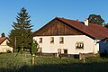
Freiberg farmhouse

Foundation for the Horse, Maison Rouge

Kloesterli, Maison Rouge


Web links
- Official website of the municipality of Les Bois
- Claude Rebetez: Bois, Les. In: Historical Lexicon of Switzerland .
Individual evidence
- ↑ Permanent and non-permanent resident population by year, canton, district, municipality, population type and gender (permanent resident population). In: bfs. admin.ch . Federal Statistical Office (FSO), August 31, 2019, accessed on December 22, 2019 .
La Chaux-des-Breuleux | Lajoux | Le Bémont | Le Noirmont | Les Bois | Les Breuleux | Les Enfers | Les Genevez | Montfaucon | Muriaux | Saignelégier | Saint-Brais | Soubey
Former parishes: Epauvillers | Epiquerez | Goumois | Le Peuchapatte | Les Pommerats | Montfavergier
Canton of Jura | Districts of Switzerland | Municipalities of the Canton of Jura