
Soubey
| Soubey | |
|---|---|
 |
|
| State : |
|
| Canton : |
|
| District : | Franches-Montagnes |
| BFS no. : | 6759 |
| Postal code : | 2887 |
| Coordinates : | 570614 / 239945 |
| Height : | 476 m above sea level M. |
| Height range : | 460–904 m above sea level M. |
| Area : | 13.49 km² |
| Residents: | 126 (December 31, 2018) |
| Population density : | 9 inhabitants per km² |
| Website: | www.soubey.ch |
 Soubey |
|
| Location of the municipality | |
  |
|
Soubey is a municipality in the Franches-Montagnes district in the canton of Jura in Switzerland .
geography
Soubey lies at 476 m above sea level. M. , seven kilometers northeast of the district capital Saignelégier (air line) and 10 km southwest of Saint-Ursanne . The farming village stretches across the Doubs valley on both sides of the river, which is cut deep into the Jura chains .
The area of the 13.5 km² municipal area covers a section of the Clos du Doubs region . The deep Doubstal has up to 500 m high valley flanks, some with meadows, some with forest and in some places are criss-crossed by ledges. The Doubs itself is mostly accompanied by a 200 to 300 m wide, flat flood plain. In the south, the municipality extends up the slope of the Côte du Bouvier and reaches Roches at 910 m above sea level at the Rouges . M. the highest point of Soubey. To the north, the area extends to the ridge of the Clos du Doubs (up to 899 m above sea level ) with the heights of Pâture des Plains , Pâturage des Laives and Pâture d'Amont . In 1997, 2% of the municipal area was in settlements, 59% in forests and woodlands, 37% in agriculture and a little more than 2% was unproductive land.
Soubey includes the hamlets Lobchez ( 483 m above sea level ) on the right (south) bank of the Doubs west of the village, Chercenay ( 575 m above sea level ) and Froidevaux ( 678 m above sea level ), both on terraces on the northern slope of the Doubs, Clairbief ( 482 m above sea level ) directly on the French border, 4.5 km upstream from Soubey, as well as numerous individual farms. Neighboring communities of Soubey are Saignelégier , Les Enfers , Montfaucon and Clos du Doubs in the canton of Jura and Burnevillers and Indevillers in neighboring France .
population
With 126 inhabitants (as of December 31, 2018) Soubey is one of the small communities in the canton of Jura. 83.8% of the residents are French-speaking and 16.2% German-speaking (as of 2000). The population of Soubey was 417 in 1880 and 352 in 1900. As a result of strong emigration, a further decline of around 60% was recorded in the course of the 20th century.
economy
Soubey is a still strongly agricultural village with dairy farming , cattle breeding , some arable farming and fruit growing on the climatically favored sunny slopes to the left of the Doubs. Outside the primary sector there are only a few jobs in the village in local small businesses. Many workers are therefore commuters. Thanks to its beautiful location on the Doubs, Soubey benefits from tourism ; the river valley is ideal for canoeing , fishing and long hikes.
traffic
The community is located off the main road connections, near the main road 18 (7.8 km), which is accessible via Montfaucon ; another road leads from Saint-Ursanne to Soubey. With a regularly trains running post bus you will reach Saint-Ursanne . Twice a day in summer on Wednesdays and Saturdays, every 2 hours on Sundays, there is also a bus to Montfaucon and Saignelégier . The nearest train station is 1.2 km south of Montfaucon on the railway line from Glovelier to La Chaux-de-Fonds.
history
The village is first mentioned in 1340 as Subeis , which belonged to the parish of Chercenay. A chapel is mentioned as early as 1139 in the hamlet of Chercenay. The hamlets of Froidevaux and Lobchez also appear earlier in the documents than Soubey. The place was under the provost of Saint-Ursanne. From 1793 to 1815 Soubey belonged to France and was initially part of the Département du Mont-Terrible , from 1800 it was linked to the Département Haut-Rhin . By decision of the Congress of Vienna , the place came to the canton of Bern in 1815 and on January 1, 1979 to the newly founded canton of Jura.
Personalities
- Pierre Paupe (1937–2016), politician
Attractions
The parish church of Saint-Valbert, which has a roof made of limestone slabs, was built in 1632. It is equipped with modern windows (1962) by the artist Coghuf . In the center of Soubey there are still old houses from the 17th to 19th centuries. A little to the east of the village there is a mill by the Bief stream, the origins of which go back to 1565. It was in operation until the second half of the 20th century and has a paddle wheel with a diameter of 6 m.
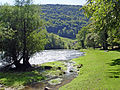
photos

Soubey on the Doubs
The course of the Doubs in the Clos du Doubs, 4.6 km east of Soubey

Hamlet Moulin-Jeannottat on the Doubs between Soubey and Goumois

Road to Soubey from Montfaucon

Quiet course of the Doubs near Soubey

Hamlet of Tariche on the Doubs

Bridge over the Doubs

Primary school building

Stained glass window (church) by Goghuf


Web links
- Official website of the municipality of Soubey
- François Kohler: Soubey. In: Historical Lexicon of Switzerland .
Individual evidence
- ↑ Permanent and non-permanent resident population by year, canton, district, municipality, population type and gender (permanent resident population). In: bfs. admin.ch . Federal Statistical Office (FSO), August 31, 2019, accessed on December 22, 2019 .
- ↑ Doubs hiking trail.
La Chaux-des-Breuleux | Lajoux | Le Bémont | Le Noirmont | Les Bois | Les Breuleux | Les Enfers | Les Genevez | Montfaucon | Muriaux | Saignelégier | Saint-Brais | Soubey
Former parishes: Epauvillers | Epiquerez | Goumois | Le Peuchapatte | Les Pommerats | Montfavergier
Canton of Jura | Districts of Switzerland | Municipalities of the Canton of Jura