
Les Breuleux
| Les Breuleux | |
|---|---|
 |
|
| State : |
|
| Canton : |
|
| District : | Franches-Montagnes |
| BFS no. : | 6743 |
| Postal code : | 2345 |
| Coordinates : | 567 088 / 229154 |
| Height : | 1038 m above sea level M. |
| Height range : | 973–1178 m above sea level M. |
| Area : | 10.82 km² |
| Residents: | 1526 (December 31, 2018) |
| Population density : | 141 inhabitants per km² |
| Website: | www.breuleux.ch |
 View towards the town center |
|
| Location of the municipality | |
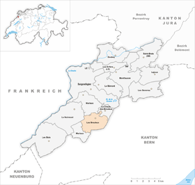  |
|


Les Breuleux is a municipality in the Franches-Montagnes district in the canton of Jura in Switzerland . The former German name Brandisholz is no longer used today.
geography
Les Breuleux is 1038 m above sea level. M. , 5 km south of the district capital Saignelégier (air line). The village is located on a sloping south-facing slope on the Jura plateau of Freiberge (French Freiberge ).
The area of the 10.8 km² municipal area comprises a section of the gently undulating plateau of the Plateaujura, on which boggy, mostly above-ground drainage-free depressions alternate with limestone peaks . The central part of the area forms the valley of Les Breuleux, which lies between two Jura chains, with extensive pastures outside the village, which are divided by large spruce trees standing individually or in groups . To the south is the Pâturage Communal forest area . In the far south, the municipality extends to the northern slope of the Montagne du Droit Jura range (up to 1113 m above sea level ). To the west, Les Breuleux extends up to the height of Point de Vue , at 1185 m above sea level. M. the highest point of the municipality is reached. In 1997, 7% of the municipal area was accounted for by settlements, 31% by forests and trees and 62% by agriculture.
Les Vacheries ( 1035 m above sea level ) and numerous individual farms belong to Les Breuleux to the west of the village . The neighboring communities of Les Breuleux are Muriaux , Le Noirmont and La Chaux-des-Breuleux in the canton of Jura and Courtelary , Cormoret and Villeret in the canton of Bern .
population
| Population development | |
|---|---|
| year | Residents |
| 1850 | 736 |
| 1900 | 1442 |
| 1910 | 1437 |
| 1930 | 1196 |
| 1950 | 1240 |
| 1960 | 1456 |
| 1970 | 1393 |
| 1980 | 1265 |
| 1990 | 1268 |
| 2000 | 1347 |
With 1,526 inhabitants (as of December 31, 2018), Les Breuleux is one of the larger municipalities in the canton of Jura. 92.6% of the residents are French-speaking, 3.1% Portuguese-speaking and 2.2% German-speaking (as of 2000). The population of Les Breuleux increased sharply in the second half of the 19th century. Around 1900 and 1960 it reached highs of around 1460 inhabitants. A significant decline was recorded as a result of the economic crisis of the 1970s.
economy
Les Breuleux developed from an agricultural village into an industrial community at the beginning of the 19th century . Today around 8% of the population are still active in agriculture, which mainly includes dairy farming and cattle breeding . In the 19th century the textile industry and then the watch industry were of great importance. Smaller companies are currently still offering jobs in watchmaking , and there are also metal and wood processing companies.
traffic
The municipality is located at the crossroads of the cantonal roads from Saignelégier to Saint-Imier and from Tramelan to La Chaux-de-Fonds . On December 16, 1913, the meter-gauge Tramelan-Breuleux-Noirmont railway , a predecessor of the Chemins de fer du Jura (CJ), opened with a station in Les Breuleux. The connection with Saint-Imier is made by bus routes.
history
Les Breuleux is first mentioned in 1429 as Les Bruilluit . This is followed by numerous other spellings: Brulluy (1440), Breluy (1472), Brüly (1494), Breulut (1495), Bruluz (1503), Les Bruleux (1526), Les Brülluers (1527), Les Bresleux (1528), before In 1534 the current name appeared.
At first the place was part of La Chaux-des-Breuleux , in 1472 it became independent. Les Breuleux belonged to the dominion of Freiberge, which was under the principality of Basel . From 1793 to 1815 Les Breuleux belonged to France and was initially part of the Département du Mont-Terrible , from 1800 it was linked to the Département Haut-Rhin . By decision of the Congress of Vienna , the place came to the canton of Bern in 1815 and on January 1, 1979 to the newly founded canton of Jura. On June 12, 1926, several houses were destroyed by a tornado .
Attractions
The first construction of the parish church of Saint-Joseph was built in 1662. From 1852 to 1855 the church was rebuilt in the neoclassical style and enlarged in 1966. Les Breuleux belonged to the parish of Montfaucon until 1629 , then to the parish of Saignelégier until 1661 , since then it has formed its own parish. In Peu-Girard there is a characteristic farmhouse from the 18th century.
photos

Grand'Rue
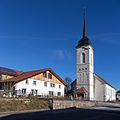
Parish church

movie theater

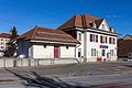
old school house, parish office
railway station

Multipurpose hall (Salle polyvalente)
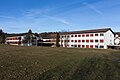
Schoolhouses


Web links
- Official website of the municipality of Les Breuleux (French)
- Claude Rebetez: Breuleux, Les. In: Historical Lexicon of Switzerland .
Individual evidence
- ↑ Permanent and non-permanent resident population by year, canton, district, municipality, population type and gender (permanent resident population). In: bfs. admin.ch . Federal Statistical Office (FSO), August 31, 2019, accessed on December 22, 2019 .
La Chaux-des-Breuleux | Lajoux | Le Bémont | Le Noirmont | Les Bois | Les Breuleux | Les Enfers | Les Genevez | Montfaucon | Muriaux | Saignelégier | Saint-Brais | Soubey
Former parishes: Epauvillers | Epiquerez | Goumois | Le Peuchapatte | Les Pommerats | Montfavergier
Canton of Jura | Districts of Switzerland | Municipalities of the Canton of Jura